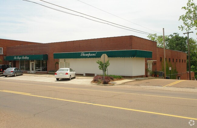
Property Record
143 W Government St, Brandon, MS 39042
NEARBY LISTINGS FOR SALE OR LEASE
Property Detail
143 W Government St
I08K-000033-00000
A LOT 53.92X134.33X53.49X133.55 IN SW4 S OF HWY 80 (0.17 AC) DB 117 PG 325 0040646 DB 131- 131 PG 40- 43 0020851
Storebuilding
Rankin
X
Mississippi
28121C0215F
0.17 AC
2024
Brandon/Flowood/Pearl
2024
Jackson
020806
Jackson, MS
8,618 SF
DEMOGRAPHICS near 143 W Government St
1 Mile
3 Mile
5 Mile
2024 Total Population
4,851
24,758
46,932
2029 Population
4,962
25,428
48,127
Pop Growth 2024-2029
+ 2.29%
+ 2.71%
+ 2.55%
Average Age
38
40
40
2024 Total Households
1,925
9,622
17,993
HH Growth 2024-2029
+ 2.13%
+ 2.65%
+ 2.47%
Median Household Inc
$71,435
$82,572
$81,070
Avg Household Size
2.40
2.50
2.50
2024 Avg HH Vehicles
2.00
2.00
2.00
Median Home Value
$223,933
$232,174
$226,381
Median Year Built
1999
1995
1995
Nearby Places
- Restaurants
- Banks
- Shops
- Fitness
- Groceries
PUBLIC TRANSPORTATION
AIRPORT
Jackson-Medgar Wiley Evers International
DRIVE
WALK
Distance
Jackson-Medgar Wiley Evers International
14 min
7.3 mi
Freight Ports
Port of Gulf Port
DRIVE
WALK
Distance
Port of Gulf Port
200 min
156.6 mi
SALE & LEASE HISTORY
LISTING DATE
SALE/LEASE

Mar 01, 2018
For Lease
Nearby Properties
Address
Land Use
TOTAL SIZE
Lot Size
Zoning
Address
Land Use
TOTAL SIZE
Lot Size
Zoning
57,040 SF
6.83 AC
Address
Land Use
TOTAL SIZE
Lot Size
Zoning
179,539 SF
18.61 AC
Address
Land Use
TOTAL SIZE
Lot Size
Zoning
23,401 SF
23.11 AC
Address
Land Use
TOTAL SIZE
Lot Size
Zoning
9.40 AC
Address
Land Use
TOTAL SIZE
Lot Size
Zoning
354,086 SF
26.82 AC
Address
Land Use
TOTAL SIZE
Lot Size
Zoning
59,260 SF
5.10 AC
Address
Land Use
TOTAL SIZE
Lot Size
Zoning
8,926 SF
14 AC
Address
Land Use
TOTAL SIZE
Lot Size
Zoning
10,996 SF
13.89 AC
Address
Land Use
TOTAL SIZE
Lot Size
Zoning
45.54 AC
Address
Land Use
TOTAL SIZE
Lot Size
Zoning
27.70 AC
Address
Land Use
TOTAL SIZE
Lot Size
Zoning
32,771 SF
17.99 AC
Address
Land Use
TOTAL SIZE
Lot Size
Zoning
180,718 SF
9.90 AC
Address
Land Use
TOTAL SIZE
Lot Size
Zoning
16,964 SF
30.85 AC
Address
Land Use
TOTAL SIZE
Lot Size
Zoning
36,230 SF
10.23 AC
Address
Land Use
TOTAL SIZE
Lot Size
Zoning
111,879 SF
12.54 AC
Address
Land Use
TOTAL SIZE
Lot Size
Zoning
7,216 SF
11.75 AC
Address
Land Use
TOTAL SIZE
Lot Size
Zoning
9,839 SF
0.92 AC
Address
Land Use
TOTAL SIZE
Lot Size
Zoning
8,964 SF
16.76 AC
Address
Land Use
TOTAL SIZE
Lot Size
Zoning
12.23 AC
Address
Land Use
TOTAL SIZE
Lot Size
Zoning
7,172 SF
2.50 AC
Address
Land Use
TOTAL SIZE
Lot Size
Zoning
24,750 SF
6.97 AC
Address
Land Use
TOTAL SIZE
Lot Size
Zoning
109.19 AC
Address
Land Use
TOTAL SIZE
Lot Size
Zoning
13,895 SF
7.60 AC
Address
Land Use
TOTAL SIZE
Lot Size
Zoning
134.94 AC
Address
Land Use
TOTAL SIZE
Lot Size
Zoning
108,118 SF
9.06 AC
Address
Land Use
TOTAL SIZE
Lot Size
Zoning
25,610 SF
6 AC
Address
Land Use
TOTAL SIZE
Lot Size
Zoning
47,718 SF
7.74 AC
Address
Land Use
TOTAL SIZE
Lot Size
Zoning
17,490 SF
5.46 AC
Address
Land Use
TOTAL SIZE
Lot Size
Zoning
Address
Land Use
TOTAL SIZE
Lot Size
Zoning
18,008 SF
4.97 AC
The World's #1 Commercial Real Estate Marketplace
Connect with us
© 2025 CoStar Group
The information above has been obtained from sources believed reliable. While we do not doubt its accuracy we have not verified it and make no guarantee, warranty or representation about it. It is your responsibility to independently confirm its accuracy and completeness. Any projections, opinions, assumptions, or estimates used are for example only and do not represent the current or future performance of the property. The value of this transaction to you depends on tax and other factors which should be evaluated by your tax, financial, and legal advisors. You and your advisors should conduct a careful, independent investigation of the property to determine to your satisfaction the suitability of the property for your needs.