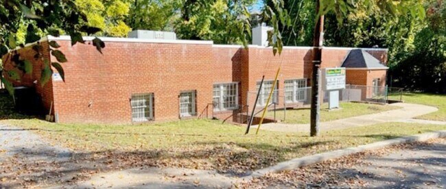
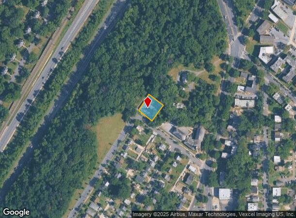
Property Record
141 Xenia St Sw, Washington, DC 20032
NEARBY LISTINGS FOR SALE OR LEASE
Property Detail
141 Xenia St Sw
Washington-Arlington-Alexandria, DC-VA-MD-WV
Congress Heights
PAR-0244-0048
SQUARE PAR SUFFIX 0244 LOT 0048 NBHD: CONGRESS HEIGHTS
Religious
District of Columbia
X
District of Columbia
5155190035F
48
0
0.31 AC
2025
Southeast
009807
Washington, DC
5,554 SF
DEMOGRAPHICS near 141 Xenia St Sw
1 Mile
3 Mile
5 Mile
2024 Total Population
28,296
178,308
508,148
2029 Population
25,862
169,359
484,585
Pop Growth 2024-2029
(8.60%)
(5.02%)
(4.64%)
Average Age
35
38
38
2024 Total Households
11,102
79,433
234,958
HH Growth 2024-2029
(9.51%)
(5.16%)
(4.98%)
Median Household Inc
$44,237
$74,859
$95,087
Avg Household Size
2.40
2.20
2.10
2024 Avg HH Vehicles
1.00
1.00
1.00
Median Home Value
$352,919
$445,638
$523,238
Median Year Built
1964
1970
1970
Nearby Places
Map Layers
Map Styles
 Street
 Aerial
- Restaurants
- Banks
- Shops
- Fitness
- Groceries
PUBLIC TRANSPORTATION
COMMUTER RAIL
Alexandria (Fredericksburg Line - Virginia Railway Express, Manassas Line - Virginia Railway Express)
DRIVE
WALK
Distance
Alexandria (Fredericksburg Line - Virginia Railway Express, Manassas Line - Virginia Railway Express)
14 min
7.3 mi
Crystal City (Fredericksburg Line - Virginia Railway Express, Manassas Line - Virginia Railway Express)
DRIVE
WALK
Distance
Crystal City (Fredericksburg Line - Virginia Railway Express, Manassas Line - Virginia Railway Express)
14 min
8.2 mi
AIRPORT
Ronald Reagan Washington Ntl
DRIVE
WALK
Distance
Ronald Reagan Washington Ntl
17 min
9.6 mi
Baltimore/Washington International Thurgood Marshall
DRIVE
WALK
Distance
Baltimore/Washington International Thurgood Marshall
51 min
33.8 mi
Washington Dulles International
DRIVE
WALK
Distance
Washington Dulles International
54 min
34.0 mi
Freight Ports
Port of Baltimore
DRIVE
WALK
Distance
Port of Baltimore
61 min
40.3 mi
SALE & LEASE HISTORY
LISTING DATE
SALE/LEASE

Nov 04, 2022
For Lease
Nearby Properties
Address
Land Use
TOTAL SIZE
Lot Size
Zoning
Address
Land Use
TOTAL SIZE
Lot Size
Zoning
900,000 SF
11.10 AC
S-3A
Address
Land Use
TOTAL SIZE
Lot Size
Zoning
19.46 AC
CG-4
Address
Land Use
TOTAL SIZE
Lot Size
Zoning
1,241,298 SF
11.53 AC
RTOLE
Address
Land Use
TOTAL SIZE
Lot Size
Zoning
2,369,428 SF
7.93 AC
MU-10;SEFC
Address
Land Use
TOTAL SIZE
Lot Size
Zoning
1,719,751 SF
39.48 AC
PDR-3;UNZO
Address
Land Use
TOTAL SIZE
Lot Size
Zoning
782,765 SF
94.06 AC
CG-5;CG-6;
Address
Land Use
TOTAL SIZE
Lot Size
Zoning
437,938 SF
11.28 AC
CG-4
Address
Land Use
TOTAL SIZE
Lot Size
Zoning
4,000,000 SF
352.96 AC
UNZONED
Address
Land Use
TOTAL SIZE
Lot Size
Zoning
3,231,903 SF
173.70 AC
UNZONED
Address
Land Use
TOTAL SIZE
Lot Size
Zoning
1,931,127 SF
11.53 AC
RTOLE
Address
Land Use
TOTAL SIZE
Lot Size
Zoning
35.71 AC
P-S/RA8-18
Address
Land Use
TOTAL SIZE
Lot Size
Zoning
336,904 SF
2.12 AC
CDD#15
Address
Land Use
TOTAL SIZE
Lot Size
Zoning
450,000 SF
37.35 AC
UNZONED
Address
Land Use
TOTAL SIZE
Lot Size
Zoning
30,000 SF
819.17 AC
PDR-1;RA-1
Address
Land Use
TOTAL SIZE
Lot Size
Zoning
5.85 AC
RA4.8
Address
Land Use
TOTAL SIZE
Lot Size
Zoning
356,000 SF
16.42 AC
RA-1;RF-1
Address
Land Use
TOTAL SIZE
Lot Size
Zoning
53,549 SF
3.50 AC
C-O
Address
Land Use
TOTAL SIZE
Lot Size
Zoning
16,782 SF
1.67 AC
C-O-1.5
Address
Land Use
TOTAL SIZE
Lot Size
Zoning
568,512 SF
2 AC
C-O
Address
Land Use
TOTAL SIZE
Lot Size
Zoning
400,000 SF
1.05 AC
D-5
Address
Land Use
TOTAL SIZE
Lot Size
Zoning
350,000 SF
1.26 AC
SEFC-1B
Address
Land Use
TOTAL SIZE
Lot Size
Zoning
852,063 SF
0.88 AC
CG-4
Address
Land Use
TOTAL SIZE
Lot Size
Zoning
2 SF
2.03 AC
C-O-1.5
Address
Land Use
TOTAL SIZE
Lot Size
Zoning
410,316 SF
0.77 AC
D-5
Address
Land Use
TOTAL SIZE
Lot Size
Zoning
6,764 SF
3.83 AC
RA4.8
Address
Land Use
TOTAL SIZE
Lot Size
Zoning
514,822 SF
44.64 AC
Address
Land Use
TOTAL SIZE
Lot Size
Zoning
481,325 SF
2.55 AC
CG-5
Address
Land Use
TOTAL SIZE
Lot Size
Zoning
980,000 SF
4.52 AC
C-O
Address
Land Use
TOTAL SIZE
Lot Size
Zoning
981,001 SF
2.24 AC
C-O
The World's #1 Commercial Real Estate Marketplace
Connect with us
© 2025 CoStar Group
The information above has been obtained from sources believed reliable. While we do not doubt its accuracy we have not verified it and make no guarantee, warranty or representation about it. It is your responsibility to independently confirm its accuracy and completeness. Any projections, opinions, assumptions, or estimates used are for example only and do not represent the current or future performance of the property. The value of this transaction to you depends on tax and other factors which should be evaluated by your tax, financial, and legal advisors. You and your advisors should conduct a careful, independent investigation of the property to determine to your satisfaction the suitability of the property for your needs.