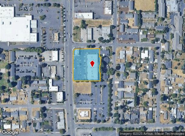
Property Record
1426 Lancaster Dr Ne, Salem, OR 97301
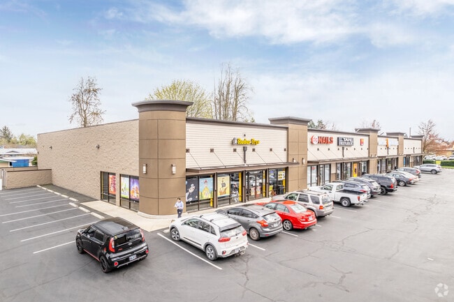

This Property Is For Sale
NEARBY LISTINGS FOR SALE OR LEASE
Property Detail
1426 Lancaster Dr Ne
Salem, OR
Heltzels Garden Tracts Amended Plat
576495
HELTZELS GARDEN TRACTS AMENDED PLAT BLOCK 9 LOT FR B ACRES 1.65
Officebuilding
Marion
X
Oregon
41047C0375G
b
2024
1.65 AC
2025
Marion County
001701
Portland
26,965 SF
DEMOGRAPHICS near 1426 Lancaster Dr Ne
1 mile
3 mile
5 mile
2024 Total Population
22,462
110,364
204,205
2029 Population
22,829
111,731
208,734
Pop Growth 2024-2029
+ 1.63%
+ 1.24%
+ 2.22%
Average Age
37
37
38
2024 Total Households
7,656
37,877
73,479
HH Growth 2024-2029
+ 1.68%
+ 1.29%
+ 2.37%
Median Household Inc
$48,223
$53,877
$60,548
Avg Household Size
2.80
2.70
2.60
2024 Avg HH Vehicles
2.00
2.00
2.00
Median Home Value
$263,411
$272,717
$326,363
Median Year Built
1979
1975
1976
Nearby Places
Map Layers
Map Styles
 Street
 Aerial
Transit
 Traffic
 Biking
Places
Listings with unknown addresses are not visible on the map
- Restaurants
- Banks
- Shops
- Fitness
- Groceries
PUBLIC TRANSPORTATION
COMMUTER RAIL
Drive
Walk
Distance
10 min
3.7 mi
Freight Ports
Port of Portland
Drive
Walk
Distance
Port of Portland
63 min
48.3 mi
Nearby Properties
Address
Land Use
TOTAL SIZE
Lot Size
Zoning
Address
Land Use
TOTAL SIZE
Lot Size
Zoning
978,999 SF
25.74 AC
PE
Address
Land Use
TOTAL SIZE
Lot Size
Zoning
236,837 SF
20.76 AC
PE
Address
Land Use
TOTAL SIZE
Lot Size
Zoning
118,829 SF
3.49 AC
CB
Address
Land Use
TOTAL SIZE
Lot Size
Zoning
532,684 SF
158.53 AC
PA
Address
Land Use
TOTAL SIZE
Lot Size
Zoning
145,520 SF
1.70 AC
PM
Address
Land Use
TOTAL SIZE
Lot Size
Zoning
120,642 SF
4 AC
CB
Address
Land Use
TOTAL SIZE
Lot Size
Zoning
94,577 SF
10.65 AC
PA
Address
Land Use
TOTAL SIZE
Lot Size
Zoning
305,230 SF
9.76 AC
PS
Address
Land Use
TOTAL SIZE
Lot Size
Zoning
166,344 SF
1.70 AC
PM
Address
Land Use
TOTAL SIZE
Lot Size
Zoning
183,400 SF
7.17 AC
PE; CB
Address
Land Use
TOTAL SIZE
Lot Size
Zoning
264,504 SF
28.17 AC
PS
Address
Land Use
TOTAL SIZE
Lot Size
Zoning
236,632 SF
24.45 AC
CO
Address
Land Use
TOTAL SIZE
Lot Size
Zoning
393,453 SF
24.18 AC
CR
Address
Land Use
TOTAL SIZE
Lot Size
Zoning
1,490 SF
17.41 AC
PA
Address
Land Use
TOTAL SIZE
Lot Size
Zoning
Address
Land Use
TOTAL SIZE
Lot Size
Zoning
137,002 SF
6.27 AC
PE
Address
Land Use
TOTAL SIZE
Lot Size
Zoning
33,560 SF
4.95 AC
CR
Address
Land Use
TOTAL SIZE
Lot Size
Zoning
164,539 SF
8.98 AC
CR; RM2
Address
Land Use
TOTAL SIZE
Lot Size
Zoning
122,333 SF
0.48 AC
CB
Address
Land Use
TOTAL SIZE
Lot Size
Zoning
98,733 SF
1.13 AC
CB
Address
Land Use
TOTAL SIZE
Lot Size
Zoning
152,237 SF
8.16 AC
RM2; RM1
Address
Land Use
TOTAL SIZE
Lot Size
Zoning
77,198 SF
1.71 AC
PM
Address
Land Use
TOTAL SIZE
Lot Size
Zoning
209,780 SF
19.85 AC
IC
Address
Land Use
TOTAL SIZE
Lot Size
Zoning
170,756 SF
2.65 AC
PS
Address
Land Use
TOTAL SIZE
Lot Size
Zoning
253,189 SF
12.83 AC
RM2
Address
Land Use
TOTAL SIZE
Lot Size
Zoning
105,152 SF
2.39 AC
CR
Address
Land Use
TOTAL SIZE
Lot Size
Zoning
171,702 SF
16.02 AC
CR
Address
Land Use
TOTAL SIZE
Lot Size
Zoning
115,561 SF
26.70 AC
PE; RA
Address
Land Use
TOTAL SIZE
Lot Size
Zoning
3,792 SF
34.64 AC
PE
The World's #1 Commercial Real Estate Marketplace
Connect with us
© 2026 CoStar Group
The information above has been obtained from sources believed reliable. While we do not doubt its accuracy we have not verified it and make no guarantee, warranty or representation about it. It is your responsibility to independently confirm its accuracy and completeness. Any projections, opinions, assumptions, or estimates used are for example only and do not represent the current or future performance of the property. The value of this transaction to you depends on tax and other factors which should be evaluated by your tax, financial, and legal advisors. You and your advisors should conduct a careful, independent investigation of the property to determine to your satisfaction the suitability of the property for your needs.