Property Record
1410 E Lake Rd N, Tarpon Springs, FL 34688
NEARBY LISTINGS FOR SALE OR LEASE
Property Detail
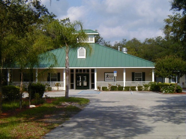
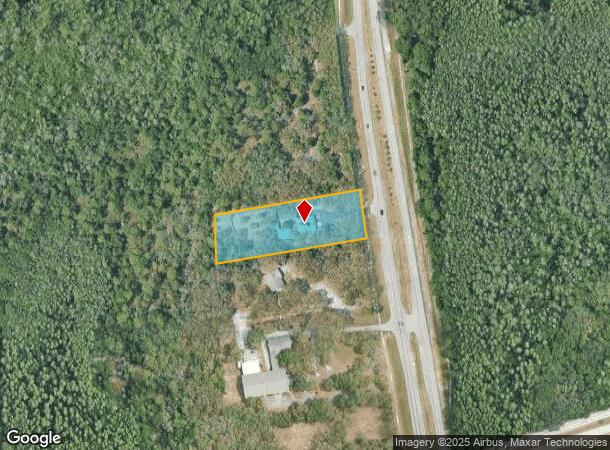
1410 E Lake Rd N
03-27-16-00000-230-0200
Pt Of Sw 1/4 Of Nw 1/4
Privateschool
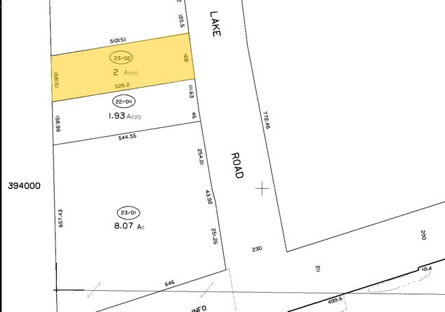
PT OF SW 1/4 OF NW 1/4 DESC AS FR SW COR OF NW 1/4 TH N ALG W SEC LINE 690FT (S) FOR POB TH CONT N ALG SD SEC LINE 169.85FT TH N81DE 508.71FT TH SELY ALG W R/W EAST LAKE RD 168.41FT TH S81DW 526.35 FT TO POB CONT 2 AC(C)
X
Pinellas
12103C0037H
Florida
2024
1.99 AC
2025
North Pinellas
027309
Tampa/St Petersburg
7,883 SF
Tampa-St. Petersburg-Clearwater, FL
DEMOGRAPHICS near 1410 E Lake Rd N
1 Mile
3 Mile
5 Mile
2024 Total Population
2,906
46,653
162,401
2029 Population
3,165
53,716
187,070
Pop Growth 2024-2029
+ 8.91%
+ 15.14%
+ 15.19%
Average Age
50
43
44
2024 Total Households
1,127
18,884
68,805
HH Growth 2024-2029
+ 8.43%
+ 15.17%
+ 15.06%
Median Household Inc
$128,554
$60,075
$53,196
Avg Household Size
2.50
2.40
2.30
2024 Avg HH Vehicles
2.00
2.00
2.00
Median Home Value
$422,787
$275,113
$229,126
Median Year Built
1993
1986
1983
Nearby Places
Map Layers
Map Styles
 Street
 Aerial
- Restaurants
- Banks
- Shops
- Fitness
- Groceries
PUBLIC TRANSPORTATION
AIRPORT
Tampa International
DRIVE
WALK
Distance
Tampa International
40 min
22.7 mi
St Pete-Clearwater International
DRIVE
WALK
Distance
St Pete-Clearwater International
41 min
22.9 mi
Nearby Properties
Address
Land Use
TOTAL SIZE
Lot Size
Zoning
Address
Land Use
TOTAL SIZE
Lot Size
Zoning
322,856 SF
70.93 AC
RPD5
Address
Land Use
TOTAL SIZE
Lot Size
Zoning
384,700 SF
18.90 AC
MF3
Address
Land Use
TOTAL SIZE
Lot Size
Zoning
403,054 SF
117.69 AC
MPUD
Address
Land Use
TOTAL SIZE
Lot Size
Zoning
314,948 SF
55.04 AC
MPUD
Address
Land Use
TOTAL SIZE
Lot Size
Zoning
333,044 SF
25.64 AC
R4
Address
Land Use
TOTAL SIZE
Lot Size
Zoning
91,644 SF
29.39 AC
RPD25
Address
Land Use
TOTAL SIZE
Lot Size
Zoning
50,741 SF
9.85 AC
RPD5
Address
Land Use
TOTAL SIZE
Lot Size
Zoning
116,607 SF
3.88 AC
MPUD
Address
Land Use
TOTAL SIZE
Lot Size
Zoning
55,440 SF
41.22 AC
RPD05
Address
Land Use
TOTAL SIZE
Lot Size
Zoning
70,248 SF
27.90 AC
R4
Address
Land Use
TOTAL SIZE
Lot Size
Zoning
89,242 SF
14.28 AC
MPUD
Address
Land Use
TOTAL SIZE
Lot Size
Zoning
121,869 SF
4.72 AC
C2
Address
Land Use
TOTAL SIZE
Lot Size
Zoning
141,763 SF
12.96 AC
Address
Land Use
TOTAL SIZE
Lot Size
Zoning
245.25 AC
PRM
Address
Land Use
TOTAL SIZE
Lot Size
Zoning
85,600 SF
13.40 AC
C2
Address
Land Use
TOTAL SIZE
Lot Size
Zoning
80,212 SF
6.64 AC
Address
Land Use
TOTAL SIZE
Lot Size
Zoning
26,743 SF
7.32 AC
RPD05
Address
Land Use
TOTAL SIZE
Lot Size
Zoning
203,135 SF
41.04 AC
C2
Address
Land Use
TOTAL SIZE
Lot Size
Zoning
74,641 SF
9.20 AC
C2
Address
Land Use
TOTAL SIZE
Lot Size
Zoning
45,674 SF
4.21 AC
Address
Land Use
TOTAL SIZE
Lot Size
Zoning
77,384 SF
6.32 AC
Address
Land Use
TOTAL SIZE
Lot Size
Zoning
50,190 SF
3 AC
MPUD
Address
Land Use
TOTAL SIZE
Lot Size
Zoning
46,278 SF
19.39 AC
MPUD
Address
Land Use
TOTAL SIZE
Lot Size
Zoning
78,299 SF
9.72 AC
C2
Address
Land Use
TOTAL SIZE
Lot Size
Zoning
71,982 SF
40.01 AC
MPUD
Address
Land Use
TOTAL SIZE
Lot Size
Zoning
18,660 SF
340.67 AC
PRM
Address
Land Use
TOTAL SIZE
Lot Size
Zoning
73.65 AC
AE
Address
Land Use
TOTAL SIZE
Lot Size
Zoning
91,835 SF
6.82 AC
C2
Address
Land Use
TOTAL SIZE
Lot Size
Zoning
52,683 SF
10.98 AC
AE
The World's #1 Commercial Real Estate Marketplace
Connect with us
© 2025 CoStar Group
The information above has been obtained from sources believed reliable. While we do not doubt its accuracy we have not verified it and make no guarantee, warranty or representation about it. It is your responsibility to independently confirm its accuracy and completeness. Any projections, opinions, assumptions, or estimates used are for example only and do not represent the current or future performance of the property. The value of this transaction to you depends on tax and other factors which should be evaluated by your tax, financial, and legal advisors. You and your advisors should conduct a careful, independent investigation of the property to determine to your satisfaction the suitability of the property for your needs.