Property Record
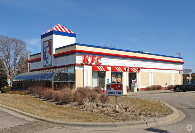
1410 Highway 60 W, Faribault, MN 55021


Property Detail
1410 Highway 60 W
Faribault-Northfield, MN
LOT BLOCK 17 OF LINCOLN ADD L17 LINCOLN ADD &; PART LOT 5 &; 6 &; 13 &; 14 ST SUB NE4 COMG NW COR NE4 TH
18.36.1.25.013
RICE
Restaurantdrivein
Minnesota
B and X Area of moderate flood hazard, usually the area between the limits of the 100-year and 500-year floods.
5,17
2026
0.95 AC
2026
Minnesota South Area
070901
Other Market Areas
2,724 SF
NEARBY LISTINGS FOR SALE OR LEASE
DEMOGRAPHICS near 1410 Highway 60 W
1 mile
3 mile
5 mile
2025 Total Population
8,492
25,894
27,980
2030 Population
8,669
26,424
28,581
Pop Growth 2025-2030
+ 2.08%
+ 2.05%
+ 2.15%
Average Age
38
40
40
2025 Total Households
3,274
9,170
10,005
HH Growth 2025-2030
+ 2.35%
+ 2.27%
+ 2.40%
Median Household Inc
$59,635
$57,929
$61,533
Avg Household Size
2.50
2.50
2.50
2025 Avg HH Vehicles
2.00
2.00
2.00
Median Home Value
$186,429
$243,352
$254,545
Median Year Built
1966
1973
1974
Nearby Places
Map Layers
Map Styles
 Street
 Aerial
Layers
 Traffic
 Biking
Places
Listings with unknown addresses are not visible on the map
- Restaurants
- Banks
- Shops
- Fitness
- Groceries
Nearby Properties
Address
Land Use
TOTAL SIZE
Lot Size
Zoning
Address
Land Use
TOTAL SIZE
Lot Size
Zoning
41,009 SF
131 AC
Address
Land Use
TOTAL SIZE
Lot Size
Zoning
915 SF
44.17 AC
Address
Land Use
TOTAL SIZE
Lot Size
Zoning
20.90 AC
Address
Land Use
TOTAL SIZE
Lot Size
Zoning
19,382 SF
11.59 AC
Address
Land Use
TOTAL SIZE
Lot Size
Zoning
2,703 SF
131.28 AC
Address
Land Use
TOTAL SIZE
Lot Size
Zoning
10,080 SF
40.71 AC
Address
Land Use
TOTAL SIZE
Lot Size
Zoning
19,763 SF
28 AC
Address
Land Use
TOTAL SIZE
Lot Size
Zoning
80,763 SF
26.50 AC
Address
Land Use
TOTAL SIZE
Lot Size
Zoning
66,089 SF
73.90 AC
Address
Land Use
TOTAL SIZE
Lot Size
Zoning
15,000 SF
20.04 AC
Address
Land Use
TOTAL SIZE
Lot Size
Zoning
6,539 SF
27.70 AC
Address
Land Use
TOTAL SIZE
Lot Size
Zoning
30,100 SF
2.86 AC
Address
Land Use
TOTAL SIZE
Lot Size
Zoning
6,512 SF
19.50 AC
Address
Land Use
TOTAL SIZE
Lot Size
Zoning
608 SF
34.30 AC
Address
Land Use
TOTAL SIZE
Lot Size
Zoning
29,204 SF
3.50 AC
Address
Land Use
TOTAL SIZE
Lot Size
Zoning
7,830 SF
2.50 AC
Address
Land Use
TOTAL SIZE
Lot Size
Zoning
39,754 SF
7.40 AC
Address
Land Use
TOTAL SIZE
Lot Size
Zoning
974 SF
7.95 AC
Address
Land Use
TOTAL SIZE
Lot Size
Zoning
89,612 SF
16.73 AC
Address
Land Use
TOTAL SIZE
Lot Size
Zoning
7,465 SF
29 AC
Address
Land Use
TOTAL SIZE
Lot Size
Zoning
4,985 SF
17.32 AC
Address
Land Use
TOTAL SIZE
Lot Size
Zoning
29,872 SF
4.58 AC
Address
Land Use
TOTAL SIZE
Lot Size
Zoning
9,490 SF
1.93 AC
Address
Land Use
TOTAL SIZE
Lot Size
Zoning
23,072 SF
2.11 AC
Address
Land Use
TOTAL SIZE
Lot Size
Zoning
15,076 SF
3.60 AC
Address
Land Use
TOTAL SIZE
Lot Size
Zoning
15,076 SF
5.10 AC
Address
Land Use
TOTAL SIZE
Lot Size
Zoning
82,428 SF
23.67 AC
Address
Land Use
TOTAL SIZE
Lot Size
Zoning
12,265 SF
4.03 AC
Address
Land Use
TOTAL SIZE
Lot Size
Zoning
13,433 SF
2.50 AC
Address
Land Use
TOTAL SIZE
Lot Size
Zoning
19,267 SF
36.05 AC
The World's #1 Commercial Real Estate Marketplace
Connect with us
© 2026 CoStar Group
The information above has been obtained from sources believed reliable. While we do not doubt its accuracy we have not verified it and make no guarantee, warranty or representation about it. It is your responsibility to independently confirm its accuracy and completeness. Any projections, opinions, assumptions, or estimates used are for example only and do not represent the current or future performance of the property. The value of this transaction to you depends on tax and other factors which should be evaluated by your tax, financial, and legal advisors. You and your advisors should conduct a careful, independent investigation of the property to determine to your satisfaction the suitability of the property for your needs.