Property Record
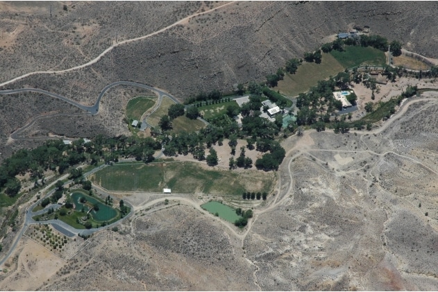
1410 S Shangrila, Toquerville, UT 84774
NEARBY LISTINGS FOR SALE OR LEASE
Property Detail
1410 S Shangrila
0108426
Toquerville Townsite Srvy
Agriculturalland
S: 14 T: 41S R: 13W BEG N0*0622 W 230 FT FM SW COR NE1/4 SW1/4 SEC 14 T41S R13W TH N0*0622 W 1086.97 FT ALG W1/16 LN NE1/4 SW1/4 SEC 14; TH N0*0442 W 1268.63 FT ALG W 1/16 LN SE1/4 NW1/4 SD SEC; TH S89*5451 E 379.50 FT ALG N 1/16 TO WLY LN ALMOND HEI
X
Washington
49053C0835G
Utah
2023
36.20 AC
2025
Cedar City & St George
270101
Other Market Areas
8,724 SF
St. George, UT
DEMOGRAPHICS near 1410 S Shangrila
1 Mile
3 Mile
5 Mile
2024 Total Population
1,706
8,447
20,039
2029 Population
2,079
10,316
24,622
Pop Growth 2024-2029
+ 21.86%
+ 22.13%
+ 22.87%
Average Age
40
39
41
2024 Total Households
533
2,669
6,797
HH Growth 2024-2029
+ 22.51%
+ 22.74%
+ 23.63%
Median Household Inc
$68,066
$49,903
$55,567
Avg Household Size
3.10
3.10
2.90
2024 Avg HH Vehicles
3.00
2.00
2.00
Median Home Value
$364,825
$325,579
$367,030
Median Year Built
1995
1993
1999
Nearby Places
Map Layers
Map Styles
 Street
 Aerial
- Restaurants
- Banks
- Shops
- Fitness
- Groceries
PUBLIC TRANSPORTATION
AIRPORT
St George Regional
DRIVE
WALK
Distance
St George Regional
41 min
29.1 mi
Freight Ports
Port of Long Beach
DRIVE
WALK
Distance
Port of Long Beach
473 min
428.2 mi
Nearby Properties
Address
Land Use
TOTAL SIZE
Lot Size
Zoning
Address
Land Use
TOTAL SIZE
Lot Size
Zoning
12,819 SF
420.57 AC
A20
Address
Land Use
TOTAL SIZE
Lot Size
Zoning
70,194 SF
2.79 AC
Address
Land Use
TOTAL SIZE
Lot Size
Zoning
50,591 SF
2.27 AC
Address
Land Use
TOTAL SIZE
Lot Size
Zoning
13,516 SF
11.45 AC
Address
Land Use
TOTAL SIZE
Lot Size
Zoning
40,650 SF
2.99 AC
Address
Land Use
TOTAL SIZE
Lot Size
Zoning
33,657 SF
12.90 AC
Address
Land Use
TOTAL SIZE
Lot Size
Zoning
30,519 SF
5.76 AC
HC
Address
Land Use
TOTAL SIZE
Lot Size
Zoning
27,033 SF
18.53 AC
Address
Land Use
TOTAL SIZE
Lot Size
Zoning
22,576 SF
5.35 AC
Address
Land Use
TOTAL SIZE
Lot Size
Zoning
48,990 SF
24.69 AC
PF
Address
Land Use
TOTAL SIZE
Lot Size
Zoning
41,124 SF
4.83 AC
Address
Land Use
TOTAL SIZE
Lot Size
Zoning
25,105 SF
2.97 AC
Address
Land Use
TOTAL SIZE
Lot Size
Zoning
87,486 SF
3.06 AC
Address
Land Use
TOTAL SIZE
Lot Size
Zoning
10,491 SF
10.93 AC
Address
Land Use
TOTAL SIZE
Lot Size
Zoning
6,550 SF
60 AC
OSC20
Address
Land Use
TOTAL SIZE
Lot Size
Zoning
7,326 SF
1.39 AC
Address
Land Use
TOTAL SIZE
Lot Size
Zoning
11,994 SF
15.02 AC
Address
Land Use
TOTAL SIZE
Lot Size
Zoning
19,050 SF
2.53 AC
M-1
Address
Land Use
TOTAL SIZE
Lot Size
Zoning
16,551 SF
7.06 AC
Address
Land Use
TOTAL SIZE
Lot Size
Zoning
15,885 SF
2.51 AC
Address
Land Use
TOTAL SIZE
Lot Size
Zoning
4.80 AC
Address
Land Use
TOTAL SIZE
Lot Size
Zoning
6.12 AC
Address
Land Use
TOTAL SIZE
Lot Size
Zoning
18,373 SF
1.39 AC
Address
Land Use
TOTAL SIZE
Lot Size
Zoning
4,309 SF
0.97 AC
Address
Land Use
TOTAL SIZE
Lot Size
Zoning
15,294 SF
10.70 AC
PF
Address
Land Use
TOTAL SIZE
Lot Size
Zoning
432 SF
3.78 AC
Address
Land Use
TOTAL SIZE
Lot Size
Zoning
15,125 SF
1.11 AC
M1
Address
Land Use
TOTAL SIZE
Lot Size
Zoning
10,242 SF
2.80 AC
The World's #1 Commercial Real Estate Marketplace
Connect with us
© 2026 CoStar Group
The information above has been obtained from sources believed reliable. While we do not doubt its accuracy we have not verified it and make no guarantee, warranty or representation about it. It is your responsibility to independently confirm its accuracy and completeness. Any projections, opinions, assumptions, or estimates used are for example only and do not represent the current or future performance of the property. The value of this transaction to you depends on tax and other factors which should be evaluated by your tax, financial, and legal advisors. You and your advisors should conduct a careful, independent investigation of the property to determine to your satisfaction the suitability of the property for your needs.