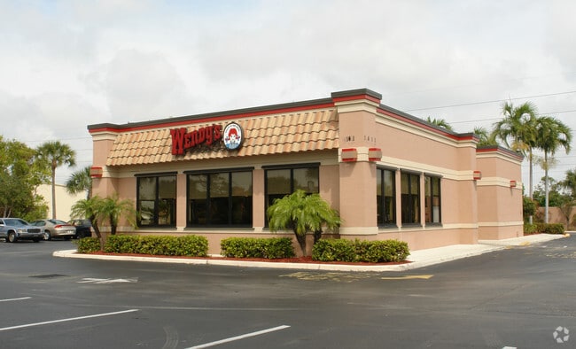
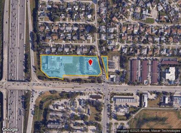
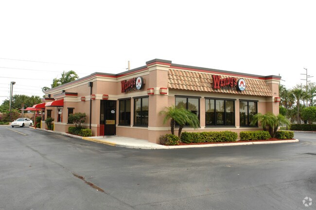
Property Record
1411 Hypoluxo Rd, Lantana, FL 33462
NEARBY LISTINGS FOR SALE OR LEASE
Property Detail
1411 Hypoluxo Rd
40-43-45-04-00-000-7400
Acreage & Unrec
Storemultistory
4-45-43~ S 380 FT OF SW 1/4 LYG E OF & ADJ TO I-95 (LESS I-95~ HYPOLUXO RD & SW 14TH ST R/WS)
X
Palm Beach
12099C0779F
Florida
2024
4.02 AC
2025
Boynton/Lantana
005502
South Florida
39,301 SF
West Palm Beach-Boca Raton-Delray Beach, FL
DEMOGRAPHICS near 1411 Hypoluxo Rd
1 Mile
3 Mile
5 Mile
2024 Total Population
12,516
115,368
271,828
2029 Population
12,765
120,493
282,318
Pop Growth 2024-2029
+ 1.99%
+ 4.44%
+ 3.86%
Average Age
40
41
42
2024 Total Households
4,481
45,168
105,725
HH Growth 2024-2029
+ 1.41%
+ 4.68%
+ 4.06%
Median Household Inc
$63,846
$61,600
$64,494
Avg Household Size
2.60
2.40
2.40
2024 Avg HH Vehicles
2.00
2.00
2.00
Median Home Value
$274,633
$289,134
$291,980
Median Year Built
1973
1983
1982
Nearby Places
Map Layers
Map Styles
 Street
 Aerial
- Restaurants
- Banks
- Shops
- Fitness
- Groceries
PUBLIC TRANSPORTATION
COMMUTER RAIL
Boynton Beach (Mangonia Park - Miami Airport - Tri-Rail, Tri-County Commuter - Tri-Rail)
DRIVE
WALK
Distance
Boynton Beach (Mangonia Park - Miami Airport - Tri-Rail, Tri-County Commuter - Tri-Rail)
6 min
2.3 mi
Lake Worth (Mangonia Park - Miami Airport - Tri-Rail, Tri-County Commuter - Tri-Rail)
DRIVE
WALK
Distance
Lake Worth (Mangonia Park - Miami Airport - Tri-Rail, Tri-County Commuter - Tri-Rail)
7 min
3.7 mi
AIRPORT
Palm Beach International
DRIVE
WALK
Distance
Palm Beach International
15 min
10.4 mi
Freight Ports
Port of Palm Beach
DRIVE
WALK
Distance
Port of Palm Beach
25 min
15.8 mi
Nearby Properties
Address
Land Use
TOTAL SIZE
Lot Size
Zoning
Address
Land Use
TOTAL SIZE
Lot Size
Zoning
337,437 SF
8.01 AC
C3
Address
Land Use
TOTAL SIZE
Lot Size
Zoning
1,346,412 SF
23.09 AC
HD PUD
Address
Land Use
TOTAL SIZE
Lot Size
Zoning
514,687 SF
19.38 AC
SMU
Address
Land Use
TOTAL SIZE
Lot Size
Zoning
525,037 SF
25.65 AC
PUD
Address
Land Use
TOTAL SIZE
Lot Size
Zoning
1,028,686 SF
63.78 AC
PID
Address
Land Use
TOTAL SIZE
Lot Size
Zoning
81,194 SF
675.47 AC
PO
Address
Land Use
TOTAL SIZE
Lot Size
Zoning
508,032 SF
18 AC
MXD
Address
Land Use
TOTAL SIZE
Lot Size
Zoning
436,808 SF
15.03 AC
MUPD
Address
Land Use
TOTAL SIZE
Lot Size
Zoning
391,475 SF
13.19 AC
SMU
Address
Land Use
TOTAL SIZE
Lot Size
Zoning
441,081 SF
20.08 AC
PUD
Address
Land Use
TOTAL SIZE
Lot Size
Zoning
357,168 SF
16.13 AC
MXD
Address
Land Use
TOTAL SIZE
Lot Size
Zoning
440,818 SF
47.57 AC
RS
Address
Land Use
TOTAL SIZE
Lot Size
Zoning
403,863 SF
24.14 AC
PUD
Address
Land Use
TOTAL SIZE
Lot Size
Zoning
327,864 SF
9.21 AC
MW
Address
Land Use
TOTAL SIZE
Lot Size
Zoning
311,983 SF
7.15 AC
C1
Address
Land Use
TOTAL SIZE
Lot Size
Zoning
340,811 SF
49.49 AC
PID
Address
Land Use
TOTAL SIZE
Lot Size
Zoning
443,576 SF
92.86 AC
PO
Address
Land Use
TOTAL SIZE
Lot Size
Zoning
211,774 SF
304.50 AC
PO
Address
Land Use
TOTAL SIZE
Lot Size
Zoning
353,007 SF
33.60 AC
RS
Address
Land Use
TOTAL SIZE
Lot Size
Zoning
437,380 SF
18.05 AC
PID
Address
Land Use
TOTAL SIZE
Lot Size
Zoning
303,078 SF
19.62 AC
PUD
Address
Land Use
TOTAL SIZE
Lot Size
Zoning
381,807 SF
3.98 AC
SMU
Address
Land Use
TOTAL SIZE
Lot Size
Zoning
296,278 SF
13.05 AC
PUD
Address
Land Use
TOTAL SIZE
Lot Size
Zoning
334,014 SF
3.35 AC
SMU
Address
Land Use
TOTAL SIZE
Lot Size
Zoning
214,095 SF
7.67 AC
PUD
Address
Land Use
TOTAL SIZE
Lot Size
Zoning
240,786 SF
10.63 AC
R3
Address
Land Use
TOTAL SIZE
Lot Size
Zoning
476,774 SF
38.76 AC
RM
Address
Land Use
TOTAL SIZE
Lot Size
Zoning
181,150 SF
4.27 AC
SMU
Address
Land Use
TOTAL SIZE
Lot Size
Zoning
182,859 SF
4.89 AC
SMU
Address
Land Use
TOTAL SIZE
Lot Size
Zoning
296,033 SF
2.04 AC
TOD-E
The World's #1 Commercial Real Estate Marketplace
Connect with us
© 2025 CoStar Group
The information above has been obtained from sources believed reliable. While we do not doubt its accuracy we have not verified it and make no guarantee, warranty or representation about it. It is your responsibility to independently confirm its accuracy and completeness. Any projections, opinions, assumptions, or estimates used are for example only and do not represent the current or future performance of the property. The value of this transaction to you depends on tax and other factors which should be evaluated by your tax, financial, and legal advisors. You and your advisors should conduct a careful, independent investigation of the property to determine to your satisfaction the suitability of the property for your needs.