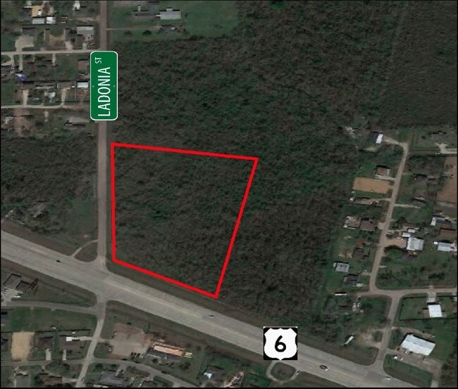
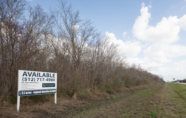
Property Record
14111 Highway 6, Rosharon, TX 77583

NEARBY LISTINGS FOR SALE OR LEASE
Property Detail
14111 Highway 6
Houston-Pasadena-The Woodlands, TX
M Escalero
0170-00-000-2012-907
0170 M ESCALERO, BLOCK 1, ACRES 2.051, A-A-A HWY 6 REPLAT NO 2, RESERVE D (COMMERCIAL)
Commercialacreage
Fort Bend
X
Texas
48039C0015K
2.05 AC
2024
E Fort Bend Co/Sugar Land
2025
Houston
661902
DEMOGRAPHICS near 14111 Highway 6
1 Mile
3 Mile
5 Mile
2024 Total Population
7,440
50,821
136,520
2029 Population
8,963
60,578
160,662
Pop Growth 2024-2029
+ 20.47%
+ 19.20%
+ 17.68%
Average Age
33
34
35
2024 Total Households
2,106
15,286
42,385
HH Growth 2024-2029
+ 20.70%
+ 19.60%
+ 18.01%
Median Household Inc
$72,023
$81,505
$103,751
Avg Household Size
3.40
3.30
3.20
2024 Avg HH Vehicles
2.00
2.00
2.00
Median Home Value
$208,699
$242,946
$306,989
Median Year Built
2007
2008
2010
Nearby Places
Map Layers
Map Styles
 Street
 Aerial
- Restaurants
- Banks
- Shops
- Fitness
- Groceries
PUBLIC TRANSPORTATION
AIRPORT
William P Hobby
DRIVE
WALK
Distance
William P Hobby
35 min
21.1 mi
Freight Ports
Port of Houston
DRIVE
WALK
Distance
Port of Houston
40 min
24.1 mi
SALE & LEASE HISTORY
LISTING DATE
SALE/LEASE

Aug 09, 2017
For Sale
Nearby Properties
Address
Land Use
TOTAL SIZE
Lot Size
Zoning
Address
Land Use
TOTAL SIZE
Lot Size
Zoning
Address
Land Use
TOTAL SIZE
Lot Size
Zoning
1,764 SF
39.64 AC
ST
Address
Land Use
TOTAL SIZE
Lot Size
Zoning
82,400 SF
10.85 AC
I
Address
Land Use
TOTAL SIZE
Lot Size
Zoning
15.28 AC
0015
Address
Land Use
TOTAL SIZE
Lot Size
Zoning
537.89 AC
Address
Land Use
TOTAL SIZE
Lot Size
Zoning
127,500 SF
7.60 AC
Address
Land Use
TOTAL SIZE
Lot Size
Zoning
105,790 SF
12.82 AC
X
Address
Land Use
TOTAL SIZE
Lot Size
Zoning
13.85 AC
Address
Land Use
TOTAL SIZE
Lot Size
Zoning
70,000 SF
64.91 AC
Address
Land Use
TOTAL SIZE
Lot Size
Zoning
132,938 SF
29 AC
MZY
Address
Land Use
TOTAL SIZE
Lot Size
Zoning
2,000 SF
24.85 AC
Address
Land Use
TOTAL SIZE
Lot Size
Zoning
28,633 SF
9.36 AC
Address
Land Use
TOTAL SIZE
Lot Size
Zoning
4.30 AC
Address
Land Use
TOTAL SIZE
Lot Size
Zoning
98,957 SF
10.70 AC
Address
Land Use
TOTAL SIZE
Lot Size
Zoning
17,481 SF
12.54 AC
Address
Land Use
TOTAL SIZE
Lot Size
Zoning
37,000 SF
6.06 AC
0218
Address
Land Use
TOTAL SIZE
Lot Size
Zoning
Address
Land Use
TOTAL SIZE
Lot Size
Zoning
114,723 SF
20.13 AC
0007
Address
Land Use
TOTAL SIZE
Lot Size
Zoning
2.92 AC
Address
Land Use
TOTAL SIZE
Lot Size
Zoning
11,400 SF
2.10 AC
Address
Land Use
TOTAL SIZE
Lot Size
Zoning
68,340 SF
3.74 AC
XS
Address
Land Use
TOTAL SIZE
Lot Size
Zoning
2.31 AC
S
Address
Land Use
TOTAL SIZE
Lot Size
Zoning
7.86 AC
SN
Address
Land Use
TOTAL SIZE
Lot Size
Zoning
14,575 SF
2.13 AC
Address
Land Use
TOTAL SIZE
Lot Size
Zoning
13,134 SF
2.08 AC
Address
Land Use
TOTAL SIZE
Lot Size
Zoning
70,260 SF
4.41 AC
SY
Address
Land Use
TOTAL SIZE
Lot Size
Zoning
36,504 SF
10 AC
0031
Address
Land Use
TOTAL SIZE
Lot Size
Zoning
16,512 SF
3.04 AC
Address
Land Use
TOTAL SIZE
Lot Size
Zoning
20,770 SF
2.93 AC
XY
Address
Land Use
TOTAL SIZE
Lot Size
Zoning
14,543 SF
2.22 AC
The World's #1 Commercial Real Estate Marketplace
Connect with us
© 2026 CoStar Group
The information above has been obtained from sources believed reliable. While we do not doubt its accuracy we have not verified it and make no guarantee, warranty or representation about it. It is your responsibility to independently confirm its accuracy and completeness. Any projections, opinions, assumptions, or estimates used are for example only and do not represent the current or future performance of the property. The value of this transaction to you depends on tax and other factors which should be evaluated by your tax, financial, and legal advisors. You and your advisors should conduct a careful, independent investigation of the property to determine to your satisfaction the suitability of the property for your needs.