Property Record
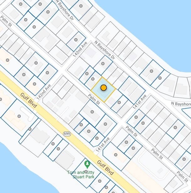
14125 Palm St, Madeira Beach, FL 33708
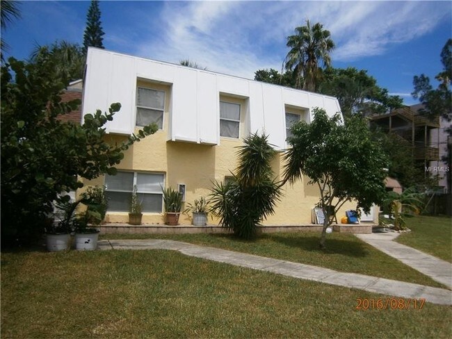

Property Detail
14125 Palm St
Tampa-St. Petersburg-Clearwater, FL
GULF SHORES 1ST ADD BLK F, LOT 6 & LOT 7 LESS SELY 10FT & LOT 5 LESS NWLY 10FT
10-31-15-34326-006-0060
Pinellas
Apartment
Florida
AE The base floodplain where base flood elevations are provided. AE Zones are now used on new format FIRMs instead of A1-A30 Zones.
6,7,5
2024
0.23 AC
2025
Madeira Beach
027802
Tampa/St Petersburg
3,751 SF
NEARBY LISTINGS FOR SALE OR LEASE
DEMOGRAPHICS near 14125 Palm St
1 mile
3 mile
5 mile
2025 Total Population
5,922
38,285
141,483
2030 Population
6,423
39,468
143,681
Pop Growth 2025-2030
+ 8.46%
+ 3.09%
+ 1.55%
Average Age
55
52
50
2025 Total Households
3,286
19,456
67,504
HH Growth 2025-2030
+ 8.49%
+ 3.15%
+ 1.74%
Median Household Inc
$94,256
$83,706
$77,208
Avg Household Size
1.80
1.90
2.00
2025 Avg HH Vehicles
2.00
2.00
2.00
Median Home Value
$881,192
$493,459
$414,710
Median Year Built
1973
1972
1972
Nearby Places
Map Layers
Map Styles
 Street
 Aerial
Layers
 Traffic
 Biking
Places
Listings with unknown addresses are not visible on the map
- Restaurants
- Banks
- Shops
- Fitness
- Groceries
PUBLIC TRANSPORTATION
AIRPORT
St Pete-Clearwater International
Drive
Walk
Distance
St Pete-Clearwater International
27 min
14.1 mi
Tampa International
Drive
Walk
Distance
Tampa International
43 min
26.5 mi
Sarasota/Bradenton International
Drive
Walk
Distance
Sarasota/Bradenton International
65 min
38.7 mi
Freight Ports
Port of Tampa Bay
Drive
Walk
Distance
Port of Tampa Bay
51 min
30.7 mi
SALE & LEASE HISTORY
LISTING DATE
SALE/LEASE

Sep 24, 2016
For Sale
Sep 23, 2016
For Sale
Sep 14, 2017
For Sale
May 29, 2020
For Sale
Nearby Properties
Address
Land Use
TOTAL SIZE
Lot Size
Zoning
Address
Land Use
TOTAL SIZE
Lot Size
Zoning
2,167,184 SF
297.75 AC
PSP
Address
Land Use
TOTAL SIZE
Lot Size
Zoning
453,486 SF
15.73 AC
Address
Land Use
TOTAL SIZE
Lot Size
Zoning
328,466 SF
18.81 AC
Address
Land Use
TOTAL SIZE
Lot Size
Zoning
101,642 SF
1.43 AC
Address
Land Use
TOTAL SIZE
Lot Size
Zoning
150,235 SF
17.90 AC
Address
Land Use
TOTAL SIZE
Lot Size
Zoning
5,647 SF
187.56 AC
AE
Address
Land Use
TOTAL SIZE
Lot Size
Zoning
142,281 SF
1.57 AC
Address
Land Use
TOTAL SIZE
Lot Size
Zoning
29,644 SF
19.13 AC
Address
Land Use
TOTAL SIZE
Lot Size
Zoning
145,619 SF
1.68 AC
Address
Land Use
TOTAL SIZE
Lot Size
Zoning
160,086 SF
1.18 AC
Address
Land Use
TOTAL SIZE
Lot Size
Zoning
204,891 SF
18.20 AC
Address
Land Use
TOTAL SIZE
Lot Size
Zoning
4,704 SF
3.36 AC
Address
Land Use
TOTAL SIZE
Lot Size
Zoning
176,209 SF
27.52 AC
Address
Land Use
TOTAL SIZE
Lot Size
Zoning
151,421 SF
1.86 AC
Address
Land Use
TOTAL SIZE
Lot Size
Zoning
49,898 SF
77.25 AC
Address
Land Use
TOTAL SIZE
Lot Size
Zoning
84,008 SF
1.49 AC
Address
Land Use
TOTAL SIZE
Lot Size
Zoning
160,616 SF
11.88 AC
Address
Land Use
TOTAL SIZE
Lot Size
Zoning
151,149 SF
8.84 AC
RM15
Address
Land Use
TOTAL SIZE
Lot Size
Zoning
6,531 SF
357.94 AC
PC
Address
Land Use
TOTAL SIZE
Lot Size
Zoning
Address
Land Use
TOTAL SIZE
Lot Size
Zoning
132,714 SF
14.83 AC
UZ
Address
Land Use
TOTAL SIZE
Lot Size
Zoning
5,590 SF
6.38 AC
Address
Land Use
TOTAL SIZE
Lot Size
Zoning
139,181 SF
22.21 AC
R2
Address
Land Use
TOTAL SIZE
Lot Size
Zoning
57,532 SF
6.96 AC
Address
Land Use
TOTAL SIZE
Lot Size
Zoning
133,610 SF
12.84 AC
Address
Land Use
TOTAL SIZE
Lot Size
Zoning
68,675 SF
2.07 AC
Address
Land Use
TOTAL SIZE
Lot Size
Zoning
64,888 SF
1.39 AC
Address
Land Use
TOTAL SIZE
Lot Size
Zoning
23,571 SF
55.32 AC
PSP
Address
Land Use
TOTAL SIZE
Lot Size
Zoning
83,103 SF
12.59 AC
AE
Address
Land Use
TOTAL SIZE
Lot Size
Zoning
26,682 SF
1.26 AC
The World's #1 Commercial Real Estate Marketplace
Connect with us
© 2026 CoStar Group
The information above has been obtained from sources believed reliable. While we do not doubt its accuracy we have not verified it and make no guarantee, warranty or representation about it. It is your responsibility to independently confirm its accuracy and completeness. Any projections, opinions, assumptions, or estimates used are for example only and do not represent the current or future performance of the property. The value of this transaction to you depends on tax and other factors which should be evaluated by your tax, financial, and legal advisors. You and your advisors should conduct a careful, independent investigation of the property to determine to your satisfaction the suitability of the property for your needs.