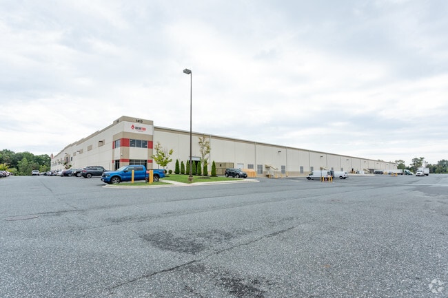
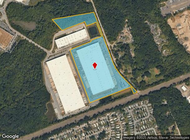
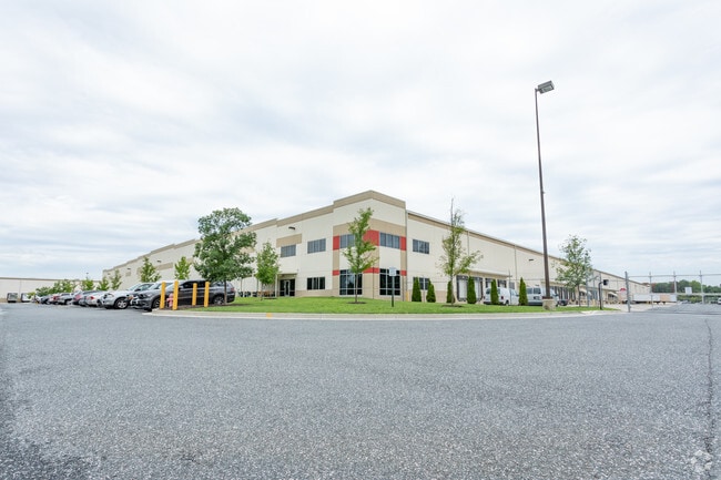
Property Record
1413 Tangier Dr, Middle River, MD 21220
NEARBY LISTINGS FOR SALE OR LEASE
Property Detail
1413 Tangier Dr
Baltimore-Columbia-Towson, MD
Bc Area 10
15-2500014141
LAND UNIT 1
Warehouse
Baltimore
X
Maryland
2400100435H
1
2024
22.60 AC
2025
Baltimore County East
451701
Baltimore
423,200 SF
DEMOGRAPHICS near 1413 Tangier Dr
1 Mile
3 Mile
5 Mile
2024 Total Population
4,447
44,051
127,965
2029 Population
4,385
43,471
126,629
Pop Growth 2024-2029
(1.39%)
(1.32%)
(1.04%)
Average Age
43
40
40
2024 Total Households
1,929
17,024
49,626
HH Growth 2024-2029
(1.56%)
(1.39%)
(1.13%)
Median Household Inc
$65,857
$74,947
$74,959
Avg Household Size
2.30
2.50
2.50
2024 Avg HH Vehicles
2.00
2.00
2.00
Median Home Value
$305,263
$277,161
$289,537
Median Year Built
1995
1982
1980
Nearby Places
Map Layers
Map Styles
 Street
 Aerial
- Restaurants
- Banks
- Shops
- Fitness
- Groceries
PUBLIC TRANSPORTATION
COMMUTER RAIL
Martin State Airport (PENN - WASHINGTON - Maryland Area Regional Commuter Trains (The MARC), Penn Line - Maryland Area Regional Commuter Trains (The MARC))
DRIVE
WALK
Distance
Martin State Airport (PENN - WASHINGTON - Maryland Area Regional Commuter Trains (The MARC), Penn Line - Maryland Area Regional Commuter Trains (The MARC))
5 min
1.7 mi
AIRPORT
Baltimore/Washington International Thurgood Marshall
DRIVE
WALK
Distance
Baltimore/Washington International Thurgood Marshall
41 min
26.3 mi
Freight Ports
Port of Baltimore
DRIVE
WALK
Distance
Port of Baltimore
28 min
17.7 mi
Nearby Properties
Address
Land Use
TOTAL SIZE
Lot Size
Zoning
Address
Land Use
TOTAL SIZE
Lot Size
Zoning
159,728 SF
0.02 AC
MH
Address
Land Use
TOTAL SIZE
Lot Size
Zoning
504,086 SF
7.48 AC
MH
Address
Land Use
TOTAL SIZE
Lot Size
Zoning
553,984 SF
7.42 AC
Address
Land Use
TOTAL SIZE
Lot Size
Zoning
83.12 AC
ML
Address
Land Use
TOTAL SIZE
Lot Size
Zoning
1,062,672 SF
70.27 AC
MHIM
Address
Land Use
TOTAL SIZE
Lot Size
Zoning
15.40 AC
DR16
Address
Land Use
TOTAL SIZE
Lot Size
Zoning
14.19 AC
DR16
Address
Land Use
TOTAL SIZE
Lot Size
Zoning
14.28 AC
DR16
Address
Land Use
TOTAL SIZE
Lot Size
Zoning
21.83 AC
DR16
Address
Land Use
TOTAL SIZE
Lot Size
Zoning
300,400 SF
31.60 AC
ML-IM
Address
Land Use
TOTAL SIZE
Lot Size
Zoning
440,340 SF
128.19 AC
Address
Land Use
TOTAL SIZE
Lot Size
Zoning
97,878 SF
12.45 AC
DR5.5
Address
Land Use
TOTAL SIZE
Lot Size
Zoning
20.13 AC
DR16
Address
Land Use
TOTAL SIZE
Lot Size
Zoning
12.47 AC
DR16
Address
Land Use
TOTAL SIZE
Lot Size
Zoning
11.69 AC
DR16
Address
Land Use
TOTAL SIZE
Lot Size
Zoning
18 AC
DR16
Address
Land Use
TOTAL SIZE
Lot Size
Zoning
89,522 SF
4.03 AC
Address
Land Use
TOTAL SIZE
Lot Size
Zoning
128,400 SF
12.68 AC
Address
Land Use
TOTAL SIZE
Lot Size
Zoning
1,914,359 SF
24.44 AC
MHIM
Address
Land Use
TOTAL SIZE
Lot Size
Zoning
300,000 SF
85.04 AC
MH
Address
Land Use
TOTAL SIZE
Lot Size
Zoning
59,061 SF
15.68 AC
Address
Land Use
TOTAL SIZE
Lot Size
Zoning
77,574 SF
3.23 AC
Address
Land Use
TOTAL SIZE
Lot Size
Zoning
141,550 SF
23.81 AC
ML
Address
Land Use
TOTAL SIZE
Lot Size
Zoning
3,844 SF
35.84 AC
Address
Land Use
TOTAL SIZE
Lot Size
Zoning
21.53 AC
DR16
Address
Land Use
TOTAL SIZE
Lot Size
Zoning
136,489 SF
33.41 AC
MLIM
Address
Land Use
TOTAL SIZE
Lot Size
Zoning
119,871 SF
29.63 AC
DR5.5
Address
Land Use
TOTAL SIZE
Lot Size
Zoning
136,978 SF
12.06 AC
MH-IM
Address
Land Use
TOTAL SIZE
Lot Size
Zoning
168,640 SF
19.02 AC
BRCS1
The World's #1 Commercial Real Estate Marketplace
Connect with us
© 2026 CoStar Group
The information above has been obtained from sources believed reliable. While we do not doubt its accuracy we have not verified it and make no guarantee, warranty or representation about it. It is your responsibility to independently confirm its accuracy and completeness. Any projections, opinions, assumptions, or estimates used are for example only and do not represent the current or future performance of the property. The value of this transaction to you depends on tax and other factors which should be evaluated by your tax, financial, and legal advisors. You and your advisors should conduct a careful, independent investigation of the property to determine to your satisfaction the suitability of the property for your needs.