Property Record
14130 Sw 57Th Avenue Rd All Units Rd, All Units, FL
NEARBY LISTINGS FOR SALE OR LEASE
-
-
View all All Units listings for sale on LoopNet.com
Property Detail
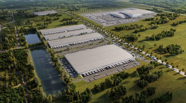
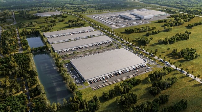
14130 Sw 57Th Avenue Rd All Units Rd
Ocala
Ocala South Logistics At Florida Crossro
Ocala, FL
SEC 16 TWP 17 RGE 21 PLAT BOOK 015 PAGE 052 FLORIDA CROSSROADS COMMERCE PARK LOT 8
41205-011-01
Marion
Warehouse
Florida
0
8
2025
13.26 AC
251,645 SF
Outlying Marion County
DEMOGRAPHICS near 14130 Sw 57Th Avenue Rd All Units Rd
1 Mile
3 Mile
5 Mile
2024 Total Population
911
23,261
51,610
2029 Population
1,069
26,960
59,167
Pop Growth 2024-2029
+ 17.34%
+ 15.90%
+ 14.64%
Average Age
39
41
47
2024 Total Households
320
8,587
20,995
HH Growth 2024-2029
+ 17.19%
+ 15.62%
+ 13.95%
Median Household Inc
$63,646
$61,498
$62,590
Avg Household Size
2.80
2.70
2.40
2024 Avg HH Vehicles
2.00
2.00
2.00
Median Home Value
$157,476
$175,158
$186,465
Median Year Built
2003
2002
2001
Nearby Places
Map Layers
Map Styles
 Street
 Aerial
- Restaurants
- Banks
- Shops
- Fitness
- Groceries
Nearby Properties
Address
Land Use
TOTAL SIZE
Lot Size
Zoning
Address
Land Use
TOTAL SIZE
Lot Size
Zoning
1,228,739 SF
200.13 AC
PUD
Address
Land Use
TOTAL SIZE
Lot Size
Zoning
250,989 SF
13.26 AC
PUD
Address
Land Use
TOTAL SIZE
Lot Size
Zoning
115,843 SF
40.89 AC
GU
Address
Land Use
TOTAL SIZE
Lot Size
Zoning
132,132 SF
16.17 AC
PUD
Address
Land Use
TOTAL SIZE
Lot Size
Zoning
74,013 SF
22.81 AC
GU
Address
Land Use
TOTAL SIZE
Lot Size
Zoning
103,764 SF
14.50 AC
R1
Address
Land Use
TOTAL SIZE
Lot Size
Zoning
59,024 SF
9.99 AC
B2
Address
Land Use
TOTAL SIZE
Lot Size
Zoning
26,223 SF
15.27 AC
B2
Address
Land Use
TOTAL SIZE
Lot Size
Zoning
60,080 SF
5.48 AC
B2
Address
Land Use
TOTAL SIZE
Lot Size
Zoning
46,723 SF
4.31 AC
B2
Address
Land Use
TOTAL SIZE
Lot Size
Zoning
8,410 SF
0.46 AC
B2
Address
Land Use
TOTAL SIZE
Lot Size
Zoning
16,054 SF
7.11 AC
B2
Address
Land Use
TOTAL SIZE
Lot Size
Zoning
9,331 SF
2,623.64 AC
A1
Address
Land Use
TOTAL SIZE
Lot Size
Zoning
14,700 SF
2.06 AC
B2
Address
Land Use
TOTAL SIZE
Lot Size
Zoning
18,344 SF
5.35 AC
R1
Address
Land Use
TOTAL SIZE
Lot Size
Zoning
476.36 AC
A1
Address
Land Use
TOTAL SIZE
Lot Size
Zoning
11,243 SF
6.20 AC
B2
Address
Land Use
TOTAL SIZE
Lot Size
Zoning
14,025 SF
2.47 AC
B2
Address
Land Use
TOTAL SIZE
Lot Size
Zoning
13,916 SF
7.20 AC
R1
Address
Land Use
TOTAL SIZE
Lot Size
Zoning
10,329 SF
0.93 AC
B2
Address
Land Use
TOTAL SIZE
Lot Size
Zoning
10,560 SF
1.02 AC
B2
Address
Land Use
TOTAL SIZE
Lot Size
Zoning
11,160 SF
1.38 AC
B2
Address
Land Use
TOTAL SIZE
Lot Size
Zoning
10,950 SF
0.98 AC
B2
Address
Land Use
TOTAL SIZE
Lot Size
Zoning
6,750 SF
0.74 AC
B2
Address
Land Use
TOTAL SIZE
Lot Size
Zoning
8,617 SF
1.38 AC
GU
Address
Land Use
TOTAL SIZE
Lot Size
Zoning
4,900 SF
1.12 AC
B2
Address
Land Use
TOTAL SIZE
Lot Size
Zoning
2,383 SF
80 AC
A1
Address
Land Use
TOTAL SIZE
Lot Size
Zoning
9,172 SF
1.06 AC
B2
Address
Land Use
TOTAL SIZE
Lot Size
Zoning
8,270 SF
1.64 AC
B2
The World's #1 Commercial Real Estate Marketplace
Connect with us
© 2026 CoStar Group
The information above has been obtained from sources believed reliable. While we do not doubt its accuracy we have not verified it and make no guarantee, warranty or representation about it. It is your responsibility to independently confirm its accuracy and completeness. Any projections, opinions, assumptions, or estimates used are for example only and do not represent the current or future performance of the property. The value of this transaction to you depends on tax and other factors which should be evaluated by your tax, financial, and legal advisors. You and your advisors should conduct a careful, independent investigation of the property to determine to your satisfaction the suitability of the property for your needs.