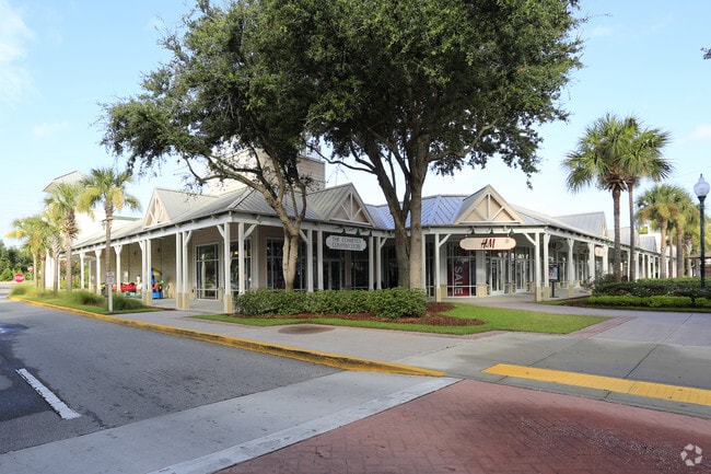
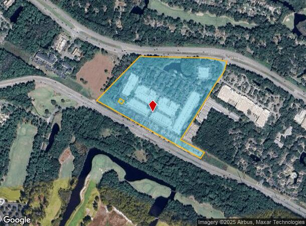
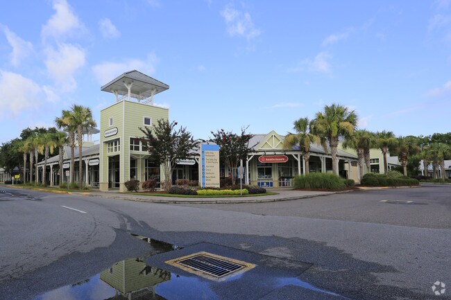
Property Record
1414 Fording Island Rd, Bluffton, SC 29910
NEARBY LISTINGS FOR SALE OR LEASE
Property Detail
1414 Fording Island Rd
Hilton Head Island-Bluffton-Beaufort, SC
Fording Island Rd Commercial
R600-040-000-0208-0000
PARS A B PB35 P151 PB47 P174 PB56 P135 *SPLIT 3/93 0.75 AC 41/171 TOT AC INCL 1.
Storebuilding
Beaufort
2025
South Carolina
2024
28.18 AC
002108
Hilton Head/Beaufort
11,664 SF
Other Market Areas
DEMOGRAPHICS near 1414 Fording Island Rd
1 Mile
3 Mile
5 Mile
2024 Total Population
2,508
13,501
34,993
2029 Population
2,778
14,865
38,590
Pop Growth 2024-2029
+ 10.77%
+ 10.10%
+ 10.28%
Average Age
45
43
43
2024 Total Households
1,061
5,391
13,771
HH Growth 2024-2029
+ 10.46%
+ 9.76%
+ 9.94%
Median Household Inc
$62,745
$64,889
$72,557
Avg Household Size
2.30
2.40
2.50
2024 Avg HH Vehicles
2.00
2.00
2.00
Median Home Value
$420,588
$395,437
$392,710
Median Year Built
1998
1999
2000
Nearby Places
- Restaurants
- Banks
- Shops
- Fitness
- Groceries
PUBLIC TRANSPORTATION
AIRPORT
Hilton Head
DRIVE
WALK
Distance
Hilton Head
15 min
8.9 mi
Savannah/Hilton Head International
DRIVE
WALK
Distance
Savannah/Hilton Head International
53 min
37.0 mi
Freight Ports
Georgia Ports - Savannah
DRIVE
WALK
Distance
Georgia Ports - Savannah
48 min
27.7 mi
Nearby Properties
Address
Land Use
TOTAL SIZE
Lot Size
Zoning
Address
Land Use
TOTAL SIZE
Lot Size
Zoning
42,800 SF
24.53 AC
6616
Address
Land Use
TOTAL SIZE
Lot Size
Zoning
239,031 SF
14.72 AC
6616
Address
Land Use
TOTAL SIZE
Lot Size
Zoning
170,736 SF
10.32 AC
6616
Address
Land Use
TOTAL SIZE
Lot Size
Zoning
156,459 SF
9.59 AC
Address
Land Use
TOTAL SIZE
Lot Size
Zoning
17,280 SF
10.77 AC
6616
Address
Land Use
TOTAL SIZE
Lot Size
Zoning
8,808 SF
14.20 AC
6616
Address
Land Use
TOTAL SIZE
Lot Size
Zoning
237,620 SF
13.37 AC
6616
Address
Land Use
TOTAL SIZE
Lot Size
Zoning
69,506 SF
3.24 AC
6616
Address
Land Use
TOTAL SIZE
Lot Size
Zoning
87,531 SF
21.48 AC
6106
Address
Land Use
TOTAL SIZE
Lot Size
Zoning
58,014 SF
11.18 AC
6616
Address
Land Use
TOTAL SIZE
Lot Size
Zoning
9,004 SF
11.91 AC
6616
Address
Land Use
TOTAL SIZE
Lot Size
Zoning
125,348 SF
9.75 AC
6616
Address
Land Use
TOTAL SIZE
Lot Size
Zoning
137,065 SF
26.18 AC
6616
Address
Land Use
TOTAL SIZE
Lot Size
Zoning
25,668 SF
302.85 AC
6616
Address
Land Use
TOTAL SIZE
Lot Size
Zoning
102,252 SF
17.35 AC
6616
Address
Land Use
TOTAL SIZE
Lot Size
Zoning
63,849 SF
10.80 AC
6616
Address
Land Use
TOTAL SIZE
Lot Size
Zoning
42,829 SF
15.21 AC
6616
Address
Land Use
TOTAL SIZE
Lot Size
Zoning
56,708 SF
9.96 AC
6616
Address
Land Use
TOTAL SIZE
Lot Size
Zoning
140,102 SF
10.15 AC
6616
Address
Land Use
TOTAL SIZE
Lot Size
Zoning
40,600 SF
10.11 AC
6616
Address
Land Use
TOTAL SIZE
Lot Size
Zoning
16,420 SF
5.75 AC
6616
Address
Land Use
TOTAL SIZE
Lot Size
Zoning
0.49 AC
6106
Address
Land Use
TOTAL SIZE
Lot Size
Zoning
50,186 SF
9.02 AC
6616
Address
Land Use
TOTAL SIZE
Lot Size
Zoning
57,132 SF
8.98 AC
6616
Address
Land Use
TOTAL SIZE
Lot Size
Zoning
21,000 SF
4.13 AC
6616
Address
Land Use
TOTAL SIZE
Lot Size
Zoning
66,078 SF
3.14 AC
6616
Address
Land Use
TOTAL SIZE
Lot Size
Zoning
70,750 SF
5.50 AC
6616
Address
Land Use
TOTAL SIZE
Lot Size
Zoning
24,454 SF
2.93 AC
6616
The World's #1 Commercial Real Estate Marketplace
Connect with us
© 2025 CoStar Group
The information above has been obtained from sources believed reliable. While we do not doubt its accuracy we have not verified it and make no guarantee, warranty or representation about it. It is your responsibility to independently confirm its accuracy and completeness. Any projections, opinions, assumptions, or estimates used are for example only and do not represent the current or future performance of the property. The value of this transaction to you depends on tax and other factors which should be evaluated by your tax, financial, and legal advisors. You and your advisors should conduct a careful, independent investigation of the property to determine to your satisfaction the suitability of the property for your needs.