Property Record
1414 Spring St, Seattle, WA 98104
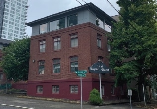
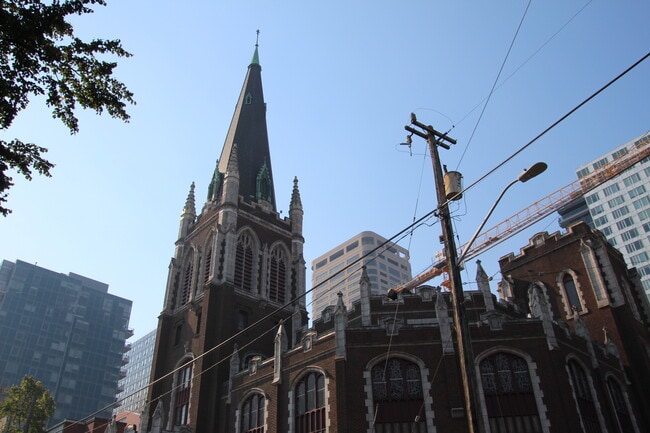
Property Detail
1414 Spring St
197820-1210
DENNYS A A BROADWAY ADD & POR VAC ST PLAT BLOCK: 136 PLAT LOT: 7
Religious
KING
HR (M)
Washington
B and X Area of moderate flood hazard, usually the area between the limits of the 100-year and 500-year floods.
7
2021
0.17 AC
2024
Capitol Hill/Central Dist
008401
Seattle/Puget Sound
17,872 SF
Seattle-Tacoma-Bellevue, WA
NEARBY LISTINGS FOR SALE OR LEASE
DEMOGRAPHICS near 1414 Spring St
1 mile
3 mile
5 mile
2025 Total Population
109,621
265,494
523,155
2030 Population
116,761
280,858
550,498
Pop Growth 2025-2030
+ 6.51%
+ 5.79%
+ 5.23%
Average Age
38
38
38
2025 Total Households
67,004
145,301
258,606
HH Growth 2025-2030
+ 6.69%
+ 6.04%
+ 5.56%
Median Household Inc
$106,219
$120,059
$123,361
Avg Household Size
1.50
1.70
1.90
2025 Avg HH Vehicles
1.00
1.00
1.00
Median Home Value
$842,634
$992,281
$1,009,879
Median Year Built
1999
1992
1985
Nearby Places
Map Layers
Map Styles
 Street
 Aerial
Transit
 Traffic
 Biking
Places
Listings with unknown addresses are not visible on the map
- Restaurants
- Banks
- Shops
- Fitness
- Groceries
PUBLIC TRANSPORTATION
TRANSIT/SUBWAY
Broadway & Marion (First Hill Streetcar - City of Seattle)
Drive
Walk
Distance
Broadway & Marion (First Hill Streetcar - City of Seattle)
0 min
3 min
0.2 mi
Broadway & Pike-Pine (First Hill Streetcar - City of Seattle)
Drive
Walk
Distance
Broadway & Pike-Pine (First Hill Streetcar - City of Seattle)
0 min
4 min
0.2 mi
Broadway And Denny (First Hill Streetcar - City of Seattle)
Drive
Walk
Distance
Broadway And Denny (First Hill Streetcar - City of Seattle)
1 min
9 min
0.5 mi
Broadway & Terrace St (First Hill Streetcar - City of Seattle)
Drive
Walk
Distance
Broadway & Terrace St (First Hill Streetcar - City of Seattle)
2 min
10 min
0.5 mi
Capitol Hill (Lynnwood - Angle Lake - Sound Transit)
Drive
Walk
Distance
Capitol Hill (Lynnwood - Angle Lake - Sound Transit)
2 min
12 min
0.6 mi
COMMUTER RAIL
King Street (Seattle) Station (Sounder South Line - Central Puget Sound Regional Transit Authority Rail (Link Light Rail/Sounder))
Drive
Walk
Distance
King Street (Seattle) Station (Sounder South Line - Central Puget Sound Regional Transit Authority Rail (Link Light Rail/Sounder))
4 min
1.4 mi
AIRPORT
Seattle-Tacoma International
Drive
Walk
Distance
Seattle-Tacoma International
24 min
14.6 mi
Seattle Paine Field International
Drive
Walk
Distance
Seattle Paine Field International
34 min
23.5 mi
Freight Ports
Port of Seattle
Drive
Walk
Distance
Port of Seattle
11 min
5.1 mi
SALE & LEASE HISTORY
LISTING DATE
SALE/LEASE

Oct 18, 2022
For Sale
Aug 20, 2020
For Lease
Nearby Properties
Address
Land Use
TOTAL SIZE
Lot Size
Zoning
Address
Land Use
TOTAL SIZE
Lot Size
Zoning
800,000 SF
8.57 AC
SM-UP 95 (
Address
Land Use
TOTAL SIZE
Lot Size
Zoning
471.20 AC
MIO-37-LR1
Address
Land Use
TOTAL SIZE
Lot Size
Zoning
2.84 AC
DMC 340/29
Address
Land Use
TOTAL SIZE
Lot Size
Zoning
793,990 SF
30.81 AC
UI U/85
Address
Land Use
TOTAL SIZE
Lot Size
Zoning
946,212 SF
1.58 AC
DMC 340/29
Address
Land Use
TOTAL SIZE
Lot Size
Zoning
686,722 SF
1.26 AC
SM-SLU 240
Address
Land Use
TOTAL SIZE
Lot Size
Zoning
36,864 SF
8.02 AC
SM-UP 95 (
Address
Land Use
TOTAL SIZE
Lot Size
Zoning
992,925 SF
4.28 AC
MIO-240-HR
Address
Land Use
TOTAL SIZE
Lot Size
Zoning
1,526,621 SF
1.36 AC
DOC1 U/450
Address
Land Use
TOTAL SIZE
Lot Size
Zoning
716,128 SF
1.41 AC
SM-SLU 175
Address
Land Use
TOTAL SIZE
Lot Size
Zoning
1,062,251 SF
1.47 AC
DOC2 500/3
Address
Land Use
TOTAL SIZE
Lot Size
Zoning
763,898 SF
2.03 AC
DOC2 500/3
Address
Land Use
TOTAL SIZE
Lot Size
Zoning
1,137,666 SF
2.07 AC
DOC1 U/450
Address
Land Use
TOTAL SIZE
Lot Size
Zoning
7,930 SF
4.14 AC
MIO-240-HR
Address
Land Use
TOTAL SIZE
Lot Size
Zoning
6,379 SF
127.60 AC
MML U/85
Address
Land Use
TOTAL SIZE
Lot Size
Zoning
1,128,575 SF
1.30 AC
DOC1 U/450
Address
Land Use
TOTAL SIZE
Lot Size
Zoning
615,000 SF
0.88 AC
DOC2 500/3
Address
Land Use
TOTAL SIZE
Lot Size
Zoning
861,221 SF
1.30 AC
DMC 340/29
Address
Land Use
TOTAL SIZE
Lot Size
Zoning
565,110 SF
29.11 AC
II U/85
Address
Land Use
TOTAL SIZE
Lot Size
Zoning
377,813 SF
1.65 AC
DOC2 500/3
Address
Land Use
TOTAL SIZE
Lot Size
Zoning
1,011,547 SF
0.35 AC
DOC1 U/450
Address
Land Use
TOTAL SIZE
Lot Size
Zoning
67,235 SF
0.45 AC
DOC2 500/3
Address
Land Use
TOTAL SIZE
Lot Size
Zoning
922,344 SF
1.33 AC
DRC 85-170
Address
Land Use
TOTAL SIZE
Lot Size
Zoning
1,478,612 SF
0.80 AC
DOC2 500/3
Address
Land Use
TOTAL SIZE
Lot Size
Zoning
413,982 SF
0.58 AC
DMC 340/29
Address
Land Use
TOTAL SIZE
Lot Size
Zoning
412,000 SF
1.27 AC
DOC1 U/450
Address
Land Use
TOTAL SIZE
Lot Size
Zoning
943,610 SF
1.24 AC
DOC1 U/450
Address
Land Use
TOTAL SIZE
Lot Size
Zoning
155,795 SF
7.89 AC
SM-UP 95 (
The World's #1 Commercial Real Estate Marketplace
Connect with us
© 2026 CoStar Group
The information above has been obtained from sources believed reliable. While we do not doubt its accuracy we have not verified it and make no guarantee, warranty or representation about it. It is your responsibility to independently confirm its accuracy and completeness. Any projections, opinions, assumptions, or estimates used are for example only and do not represent the current or future performance of the property. The value of this transaction to you depends on tax and other factors which should be evaluated by your tax, financial, and legal advisors. You and your advisors should conduct a careful, independent investigation of the property to determine to your satisfaction the suitability of the property for your needs.