Property Record
1414 W State Route 571, Tipp City, OH 45371
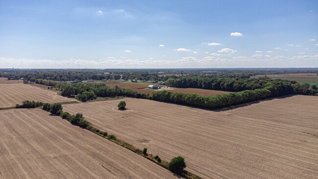
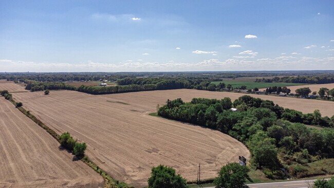
This Property Is For Sale
NEARBY LISTINGS FOR SALE OR LEASE
Property Detail
1414 W State Route 571
G12023600
6-4-20 PT W PT NE
Farms
Miami
X
Ohio
39109C0255E
50.13 AC
2024
North Dayton
2024
Cincinnati/Dayton
350101
Dayton, OH
DEMOGRAPHICS near 1414 W State Route 571
1 Mile
3 Mile
5 Mile
2024 Total Population
905
17,117
29,763
2029 Population
950
17,625
30,488
Pop Growth 2024-2029
+ 4.97%
+ 2.97%
+ 2.44%
Average Age
45
43
43
2024 Total Households
327
6,894
11,864
HH Growth 2024-2029
+ 5.50%
+ 2.89%
+ 2.39%
Median Household Inc
$93,990
$88,037
$89,743
Avg Household Size
2.50
2.40
2.50
2024 Avg HH Vehicles
3.00
2.00
2.00
Median Home Value
$312,088
$299,449
$306,927
Median Year Built
1974
1976
1974
Nearby Places
- Restaurants
- Banks
- Shops
- Fitness
- Groceries
PUBLIC TRANSPORTATION
AIRPORT
James M Cox Dayton International
DRIVE
WALK
Distance
James M Cox Dayton International
17 min
10.4 mi
Freight Ports
Port of Toledo
DRIVE
WALK
Distance
Port of Toledo
163 min
139.9 mi
Nearby Properties
Address
Land Use
TOTAL SIZE
Lot Size
Zoning
Address
Land Use
TOTAL SIZE
Lot Size
Zoning
2,810,636 SF
79.21 AC
Address
Land Use
TOTAL SIZE
Lot Size
Zoning
209,484 SF
45.46 AC
Address
Land Use
TOTAL SIZE
Lot Size
Zoning
Address
Land Use
TOTAL SIZE
Lot Size
Zoning
Address
Land Use
TOTAL SIZE
Lot Size
Zoning
Address
Land Use
TOTAL SIZE
Lot Size
Zoning
178.04 AC
Address
Land Use
TOTAL SIZE
Lot Size
Zoning
38,738 SF
11.39 AC
Address
Land Use
TOTAL SIZE
Lot Size
Zoning
Address
Land Use
TOTAL SIZE
Lot Size
Zoning
704,988 SF
49.15 AC
Address
Land Use
TOTAL SIZE
Lot Size
Zoning
49,496 SF
10.15 AC
Address
Land Use
TOTAL SIZE
Lot Size
Zoning
54,635 SF
17.25 AC
Address
Land Use
TOTAL SIZE
Lot Size
Zoning
371,869 SF
160.30 AC
Address
Land Use
TOTAL SIZE
Lot Size
Zoning
Address
Land Use
TOTAL SIZE
Lot Size
Zoning
42,377 SF
10.31 AC
Address
Land Use
TOTAL SIZE
Lot Size
Zoning
87,635 SF
6.02 AC
Address
Land Use
TOTAL SIZE
Lot Size
Zoning
6,263 SF
26.04 AC
Address
Land Use
TOTAL SIZE
Lot Size
Zoning
143,980 SF
35.40 AC
Address
Land Use
TOTAL SIZE
Lot Size
Zoning
198,355 SF
19.64 AC
Address
Land Use
TOTAL SIZE
Lot Size
Zoning
21,473 SF
8.37 AC
Address
Land Use
TOTAL SIZE
Lot Size
Zoning
96,200 SF
14.09 AC
Address
Land Use
TOTAL SIZE
Lot Size
Zoning
28,208 SF
10.32 AC
Address
Land Use
TOTAL SIZE
Lot Size
Zoning
4,579 SF
0.54 AC
Address
Land Use
TOTAL SIZE
Lot Size
Zoning
9,900 SF
4.24 AC
Address
Land Use
TOTAL SIZE
Lot Size
Zoning
9,832 SF
0.83 AC
Address
Land Use
TOTAL SIZE
Lot Size
Zoning
14,850 SF
1.78 AC
Address
Land Use
TOTAL SIZE
Lot Size
Zoning
26,250 SF
3.90 AC
Address
Land Use
TOTAL SIZE
Lot Size
Zoning
15,710 SF
7.39 AC
Address
Land Use
TOTAL SIZE
Lot Size
Zoning
12,948 SF
2.88 AC
Address
Land Use
TOTAL SIZE
Lot Size
Zoning
122,400 SF
20.34 AC
Address
Land Use
TOTAL SIZE
Lot Size
Zoning
41,084 SF
13.28 AC
The World's #1 Commercial Real Estate Marketplace
Connect with us
© 2025 CoStar Group
The information above has been obtained from sources believed reliable. While we do not doubt its accuracy we have not verified it and make no guarantee, warranty or representation about it. It is your responsibility to independently confirm its accuracy and completeness. Any projections, opinions, assumptions, or estimates used are for example only and do not represent the current or future performance of the property. The value of this transaction to you depends on tax and other factors which should be evaluated by your tax, financial, and legal advisors. You and your advisors should conduct a careful, independent investigation of the property to determine to your satisfaction the suitability of the property for your needs.