Property Record
14145 Danielson St, Poway, CA 92064


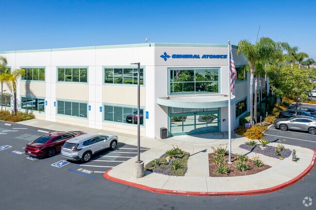
Property Detail
14145 Danielson St
San Diego-Chula Vista-Carlsbad, CA
PAR 3 NEW PAR A PER DOC99-184713 IN LOT 21 MAP 13410&IN TR PM17992
323-482-20
San Diego
Heavyindustrial
California
PC-7
21
B and X Area of moderate flood hazard, usually the area between the limits of the 100-year and 500-year floods.
7.21 AC
2025
Poway
2025
San Diego
017049
NEARBY LISTINGS FOR SALE OR LEASE
DEMOGRAPHICS near 14145 Danielson St
1 mile
3 mile
5 mile
2025 Total Population
2,235
38,661
104,247
2030 Population
2,211
38,607
104,424
Pop Growth 2025-2030
(1.07%)
(0.14%)
+ 0.17%
Average Age
39
40
41
2025 Total Households
652
12,578
36,292
HH Growth 2025-2030
(1.38%)
(0.29%)
+ 0.06%
Median Household Inc
$151,485
$152,187
$153,875
Avg Household Size
3.40
3.00
2.80
2025 Avg HH Vehicles
3.00
2.00
2.00
Median Home Value
$986,344
$1,005,778
$1,039,550
Median Year Built
1979
1981
1987
Nearby Places
Map Layers
Map Styles
 Street
 Aerial
Transit
 Traffic
 Biking
Places
Listings with unknown addresses are not visible on the map
- Restaurants
- Banks
- Shops
- Fitness
- Groceries
PUBLIC TRANSPORTATION
AIRPORT
San Diego International
Drive
Walk
Distance
San Diego International
33 min
22.2 mi
SALE & LEASE HISTORY
LISTING DATE
SALE/LEASE

Sep 25, 2016
For Lease
Sep 24, 2016
For Lease
Nearby Properties
Address
Land Use
TOTAL SIZE
Lot Size
Zoning
Address
Land Use
TOTAL SIZE
Lot Size
Zoning
38.96 AC
PC-7
Address
Land Use
TOTAL SIZE
Lot Size
Zoning
55,156 SF
6.62 AC
PC-8
Address
Land Use
TOTAL SIZE
Lot Size
Zoning
11.20 AC
PC-8
Address
Land Use
TOTAL SIZE
Lot Size
Zoning
14.87 AC
PC-7
Address
Land Use
TOTAL SIZE
Lot Size
Zoning
20.87 AC
PC-7
Address
Land Use
TOTAL SIZE
Lot Size
Zoning
41.98 AC
PC-7
Address
Land Use
TOTAL SIZE
Lot Size
Zoning
8.80 AC
RA
Address
Land Use
TOTAL SIZE
Lot Size
Zoning
16.49 AC
PC-7
Address
Land Use
TOTAL SIZE
Lot Size
Zoning
76,732 SF
5.46 AC
RA
Address
Land Use
TOTAL SIZE
Lot Size
Zoning
22.37 AC
PC-7
Address
Land Use
TOTAL SIZE
Lot Size
Zoning
10.70 AC
PC-7
Address
Land Use
TOTAL SIZE
Lot Size
Zoning
7.22 AC
PC-7
Address
Land Use
TOTAL SIZE
Lot Size
Zoning
6.66 AC
PC-7
Address
Land Use
TOTAL SIZE
Lot Size
Zoning
9.89 AC
PC-7
Address
Land Use
TOTAL SIZE
Lot Size
Zoning
8.44 AC
PC-7
Address
Land Use
TOTAL SIZE
Lot Size
Zoning
6.83 AC
PC-7
Address
Land Use
TOTAL SIZE
Lot Size
Zoning
10.60 AC
PC-7
Address
Land Use
TOTAL SIZE
Lot Size
Zoning
10.43 AC
PC-7
Address
Land Use
TOTAL SIZE
Lot Size
Zoning
9.64 AC
PC-7
Address
Land Use
TOTAL SIZE
Lot Size
Zoning
9.78 AC
PC-7
Address
Land Use
TOTAL SIZE
Lot Size
Zoning
59,078 SF
3.99 AC
PC-7
Address
Land Use
TOTAL SIZE
Lot Size
Zoning
9.07 AC
PC-8
Address
Land Use
TOTAL SIZE
Lot Size
Zoning
3,801 SF
18.59 AC
PC-7
Address
Land Use
TOTAL SIZE
Lot Size
Zoning
9.56 AC
PC-8
Address
Land Use
TOTAL SIZE
Lot Size
Zoning
80,608 SF
6.81 AC
PC-8
Address
Land Use
TOTAL SIZE
Lot Size
Zoning
95,348 SF
9.84 AC
PC-7
Address
Land Use
TOTAL SIZE
Lot Size
Zoning
16.49 AC
CG
Address
Land Use
TOTAL SIZE
Lot Size
Zoning
80,500 SF
5.84 AC
PC-7
Address
Land Use
TOTAL SIZE
Lot Size
Zoning
89,608 SF
5.12 AC
PC-8
The World's #1 Commercial Real Estate Marketplace
Connect with us
© 2026 CoStar Group
The information above has been obtained from sources believed reliable. While we do not doubt its accuracy we have not verified it and make no guarantee, warranty or representation about it. It is your responsibility to independently confirm its accuracy and completeness. Any projections, opinions, assumptions, or estimates used are for example only and do not represent the current or future performance of the property. The value of this transaction to you depends on tax and other factors which should be evaluated by your tax, financial, and legal advisors. You and your advisors should conduct a careful, independent investigation of the property to determine to your satisfaction the suitability of the property for your needs.