Property Record
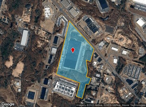
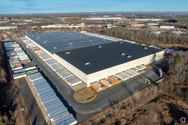
1415 Blue Hills Ave, Bloomfield, CT 06002

NEARBY LISTINGS FOR SALE OR LEASE
Property Detail
1415 Blue Hills Ave
BLOO-000373-000000-001248
Hartford
Industrialgeneral
Connecticut
X
22
09003C0351F
96.24 AC
2024
Bloomfield
2025
Hartford
471500
Hartford-West Hartford-East Hartford, CT
802,150 SF
DEMOGRAPHICS near 1415 Blue Hills Ave
1 Mile
3 Mile
5 Mile
2024 Total Population
341
19,481
73,295
2029 Population
339
19,448
72,962
Pop Growth 2024-2029
(0.59%)
(0.17%)
(0.45%)
Average Age
46
46
43
2024 Total Households
147
8,008
28,488
HH Growth 2024-2029
(0.68%)
(0.30%)
(0.56%)
Median Household Inc
$88,392
$94,583
$91,278
Avg Household Size
2.20
2.30
2.40
2024 Avg HH Vehicles
2.00
2.00
2.00
Median Home Value
$246,511
$264,655
$255,552
Median Year Built
1984
1977
1967
Nearby Places
Map Layers
Map Styles
 Street
 Aerial
- Restaurants
- Banks
- Shops
- Fitness
- Groceries
PUBLIC TRANSPORTATION
COMMUTER RAIL
Windsor (Amtrak Hartford Line - Amtrak, Hartford Line - Amtrak, Northeast Regional - Amtrak, Valley Flyer - Amtrak)
DRIVE
WALK
Distance
Windsor (Amtrak Hartford Line - Amtrak, Hartford Line - Amtrak, Northeast Regional - Amtrak, Valley Flyer - Amtrak)
12 min
5.1 mi
Windsor Locks (Hartford Line - CT Rail (CTRail))
DRIVE
WALK
Distance
Windsor Locks (Hartford Line - CT Rail (CTRail))
15 min
8.3 mi
AIRPORT
Bradley International
DRIVE
WALK
Distance
Bradley International
25 min
10.1 mi
Freight Ports
Port of New Haven
DRIVE
WALK
Distance
Port of New Haven
67 min
49.0 mi
Nearby Properties
Address
Land Use
TOTAL SIZE
Lot Size
Zoning
Address
Land Use
TOTAL SIZE
Lot Size
Zoning
105,796 SF
89.51 AC
Address
Land Use
TOTAL SIZE
Lot Size
Zoning
221,054 SF
28.85 AC
R-40
Address
Land Use
TOTAL SIZE
Lot Size
Zoning
66.60 AC
I-2
Address
Land Use
TOTAL SIZE
Lot Size
Zoning
68.36 AC
Address
Land Use
TOTAL SIZE
Lot Size
Zoning
227,898 SF
5.33 AC
BCD
Address
Land Use
TOTAL SIZE
Lot Size
Zoning
433,356 SF
45.53 AC
I-2
Address
Land Use
TOTAL SIZE
Lot Size
Zoning
93.79 AC
Address
Land Use
TOTAL SIZE
Lot Size
Zoning
65,042 SF
36.76 AC
I-2
Address
Land Use
TOTAL SIZE
Lot Size
Zoning
8.89 AC
Address
Land Use
TOTAL SIZE
Lot Size
Zoning
161,576 SF
4 AC
BCD
Address
Land Use
TOTAL SIZE
Lot Size
Zoning
77,497 SF
14.17 AC
R-20
Address
Land Use
TOTAL SIZE
Lot Size
Zoning
180,964 SF
32.10 AC
R-15
Address
Land Use
TOTAL SIZE
Lot Size
Zoning
14.02 AC
PLR
Address
Land Use
TOTAL SIZE
Lot Size
Zoning
203,071 SF
17.46 AC
Address
Land Use
TOTAL SIZE
Lot Size
Zoning
39.47 AC
R-15
Address
Land Use
TOTAL SIZE
Lot Size
Zoning
451,806 SF
37.82 AC
I-2
Address
Land Use
TOTAL SIZE
Lot Size
Zoning
215,269 SF
41 AC
I-2
Address
Land Use
TOTAL SIZE
Lot Size
Zoning
488,812 SF
77.31 AC
Address
Land Use
TOTAL SIZE
Lot Size
Zoning
152,382 SF
10.46 AC
Address
Land Use
TOTAL SIZE
Lot Size
Zoning
183,263 SF
21.69 AC
Address
Land Use
TOTAL SIZE
Lot Size
Zoning
457,396 SF
72.99 AC
Address
Land Use
TOTAL SIZE
Lot Size
Zoning
14.90 AC
R-15
Address
Land Use
TOTAL SIZE
Lot Size
Zoning
62,592 SF
31.12 AC
R-15
Address
Land Use
TOTAL SIZE
Lot Size
Zoning
15.33 AC
R-15
Address
Land Use
TOTAL SIZE
Lot Size
Zoning
25,622 SF
19.80 AC
PLR
Address
Land Use
TOTAL SIZE
Lot Size
Zoning
11,172 SF
16.04 AC
MFER
Address
Land Use
TOTAL SIZE
Lot Size
Zoning
156,950 SF
27.53 AC
I-2
Address
Land Use
TOTAL SIZE
Lot Size
Zoning
65,592 SF
6.66 AC
Address
Land Use
TOTAL SIZE
Lot Size
Zoning
239,516 SF
31.50 AC
I-2
The World's #1 Commercial Real Estate Marketplace
Connect with us
© 2025 CoStar Group
The information above has been obtained from sources believed reliable. While we do not doubt its accuracy we have not verified it and make no guarantee, warranty or representation about it. It is your responsibility to independently confirm its accuracy and completeness. Any projections, opinions, assumptions, or estimates used are for example only and do not represent the current or future performance of the property. The value of this transaction to you depends on tax and other factors which should be evaluated by your tax, financial, and legal advisors. You and your advisors should conduct a careful, independent investigation of the property to determine to your satisfaction the suitability of the property for your needs.