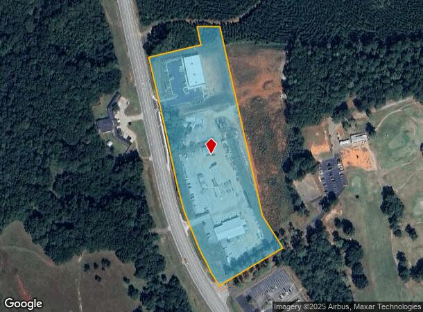
Property Record
1415 Highway 19 S, Thomaston, GA 30286
NEARBY LISTINGS FOR SALE OR LEASE
Property Detail
1415 Highway 19 S
T36-024A
Thomaston Comm Acreage
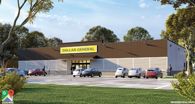
Officebuilding
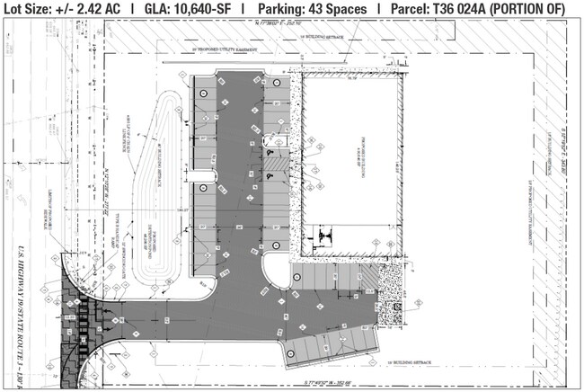
TRACT A-1R (6.278 ACS) PB 33/233
X
Upson
13293C0177D
Georgia
2025
6.28 AC
2025
Georgia South Area
010401
Other Market Areas
6,000 SF
Thomaston, GA
DEMOGRAPHICS near 1415 Highway 19 S
1 Mile
3 Mile
5 Mile
2024 Total Population
1,616
11,266
17,564
2029 Population
1,692
11,681
18,132
Pop Growth 2024-2029
+ 4.70%
+ 3.68%
+ 3.23%
Average Age
44
41
41
2024 Total Households
689
4,654
7,159
HH Growth 2024-2029
+ 4.50%
+ 3.52%
+ 3.07%
Median Household Inc
$41,215
$37,637
$39,279
Avg Household Size
2.20
2.30
2.40
2024 Avg HH Vehicles
2.00
2.00
2.00
Median Home Value
$142,187
$116,727
$114,536
Median Year Built
1954
1961
1968
Nearby Places
Map Layers
Map Styles
 Street
 Aerial
- Restaurants
- Banks
- Shops
- Fitness
- Groceries
SALE & LEASE HISTORY
LISTING DATE
SALE/LEASE

Mar 27, 2023
For Sale
Nearby Properties
Address
Land Use
TOTAL SIZE
Lot Size
Zoning
Address
Land Use
TOTAL SIZE
Lot Size
Zoning
3,000 SF
73.70 AC
AR
Address
Land Use
TOTAL SIZE
Lot Size
Zoning
90,546 SF
87.05 AC
AR
Address
Land Use
TOTAL SIZE
Lot Size
Zoning
6,768 SF
39.20 AC
MR
Address
Land Use
TOTAL SIZE
Lot Size
Zoning
9,588 SF
12.17 AC
PI
Address
Land Use
TOTAL SIZE
Lot Size
Zoning
57,512 SF
29.28 AC
006
Address
Land Use
TOTAL SIZE
Lot Size
Zoning
46,987 SF
24.32 AC
C2
Address
Land Use
TOTAL SIZE
Lot Size
Zoning
121,950 SF
12.57 AC
PI
Address
Land Use
TOTAL SIZE
Lot Size
Zoning
26,248 SF
4 AC
PI
Address
Land Use
TOTAL SIZE
Lot Size
Zoning
48,476 SF
17.80 AC
ES2
Address
Land Use
TOTAL SIZE
Lot Size
Zoning
322,698 SF
72.25 AC
M2
Address
Land Use
TOTAL SIZE
Lot Size
Zoning
27,502 SF
7 AC
PI
Address
Land Use
TOTAL SIZE
Lot Size
Zoning
34,436 SF
3.52 AC
MR
Address
Land Use
TOTAL SIZE
Lot Size
Zoning
31,412 SF
3.69 AC
DT
Address
Land Use
TOTAL SIZE
Lot Size
Zoning
34,537 SF
6.65 AC
C2
Address
Land Use
TOTAL SIZE
Lot Size
Zoning
24,662 SF
1.09 AC
DT
Address
Land Use
TOTAL SIZE
Lot Size
Zoning
28,266 SF
2.44 AC
PD
Address
Land Use
TOTAL SIZE
Lot Size
Zoning
13,765 SF
7.92 AC
PD
Address
Land Use
TOTAL SIZE
Lot Size
Zoning
4,472 SF
11.57 AC
MR
Address
Land Use
TOTAL SIZE
Lot Size
Zoning
61,916 SF
8.93 AC
C2
Address
Land Use
TOTAL SIZE
Lot Size
Zoning
4,704 SF
172.30 AC
M2
Address
Land Use
TOTAL SIZE
Lot Size
Zoning
30,719 SF
22.90 AC
PI
Address
Land Use
TOTAL SIZE
Lot Size
Zoning
21,373 SF
2.77 AC
C2
Address
Land Use
TOTAL SIZE
Lot Size
Zoning
19,660 SF
1.26 AC
DT
Address
Land Use
TOTAL SIZE
Lot Size
Zoning
12,810 SF
1.73 AC
R1
Address
Land Use
TOTAL SIZE
Lot Size
Zoning
107,468 SF
7.21 AC
M2
Address
Land Use
TOTAL SIZE
Lot Size
Zoning
600 SF
6 AC
MR
Address
Land Use
TOTAL SIZE
Lot Size
Zoning
1,081.50 AC
AR
Address
Land Use
TOTAL SIZE
Lot Size
Zoning
44,793 SF
9 AC
R2
Address
Land Use
TOTAL SIZE
Lot Size
Zoning
263,413 SF
20.59 AC
M2
Address
Land Use
TOTAL SIZE
Lot Size
Zoning
1,725 SF
10.68 AC
004
The World's #1 Commercial Real Estate Marketplace
Connect with us
© 2025 CoStar Group
The information above has been obtained from sources believed reliable. While we do not doubt its accuracy we have not verified it and make no guarantee, warranty or representation about it. It is your responsibility to independently confirm its accuracy and completeness. Any projections, opinions, assumptions, or estimates used are for example only and do not represent the current or future performance of the property. The value of this transaction to you depends on tax and other factors which should be evaluated by your tax, financial, and legal advisors. You and your advisors should conduct a careful, independent investigation of the property to determine to your satisfaction the suitability of the property for your needs.