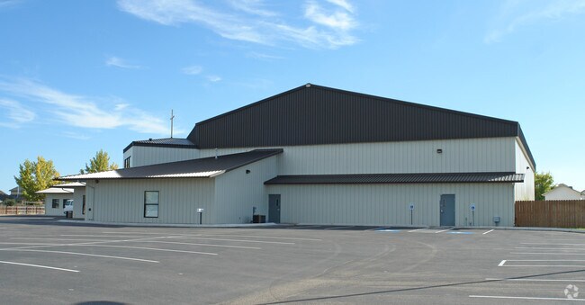
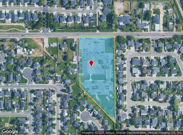
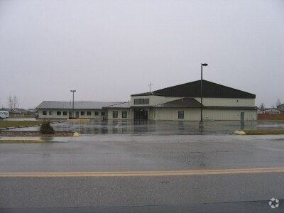
Property Record
1415 Lone Star Rd, Nampa, ID 83651
NEARBY LISTINGS FOR SALE OR LEASE
-
-
View all Nampa listings for sale on LoopNet.com
Property Detail
1415 Lone Star Rd
32001010A0
29-3N-2W NE TX 37-A IN E 1/2 NWNE
Taxexempt
Canyon
X
Idaho
16027C0378F
5 AC
0
Nampa
2025
Boise City/Nampa
020903
Boise City, ID
DEMOGRAPHICS near 1415 Lone Star Rd
1 Mile
3 Mile
5 Mile
2024 Total Population
17,017
84,565
151,694
2029 Population
20,657
103,075
185,243
Pop Growth 2024-2029
+ 21.39%
+ 21.89%
+ 22.12%
Average Age
37
37
37
2024 Total Households
5,565
29,995
51,800
HH Growth 2024-2029
+ 21.67%
+ 22.21%
+ 22.41%
Median Household Inc
$73,687
$61,858
$66,527
Avg Household Size
2.90
2.70
2.80
2024 Avg HH Vehicles
2.00
2.00
2.00
Median Home Value
$339,160
$326,816
$345,031
Median Year Built
1997
1995
2000
Nearby Places
Map Layers
Map Styles
 Street
 Aerial
- Restaurants
- Banks
- Shops
- Fitness
- Groceries
PUBLIC TRANSPORTATION
AIRPORT
Boise Air Trml/Gowen Field
DRIVE
WALK
Distance
Boise Air Trml/Gowen Field
34 min
22.9 mi
Nearby Properties
Address
Land Use
TOTAL SIZE
Lot Size
Zoning
Address
Land Use
TOTAL SIZE
Lot Size
Zoning
40.26 AC
Address
Land Use
TOTAL SIZE
Lot Size
Zoning
44.21 AC
R1
Address
Land Use
TOTAL SIZE
Lot Size
Zoning
13.10 AC
Address
Land Use
TOTAL SIZE
Lot Size
Zoning
11.26 AC
Address
Land Use
TOTAL SIZE
Lot Size
Zoning
28.08 AC
Address
Land Use
TOTAL SIZE
Lot Size
Zoning
18.74 AC
Address
Land Use
TOTAL SIZE
Lot Size
Zoning
158.05 AC
M1
Address
Land Use
TOTAL SIZE
Lot Size
Zoning
11.15 AC
Address
Land Use
TOTAL SIZE
Lot Size
Zoning
243,353 SF
20.57 AC
Address
Land Use
TOTAL SIZE
Lot Size
Zoning
244,100 SF
13.64 AC
Address
Land Use
TOTAL SIZE
Lot Size
Zoning
2.96 AC
Address
Land Use
TOTAL SIZE
Lot Size
Zoning
12.65 AC
Address
Land Use
TOTAL SIZE
Lot Size
Zoning
203,750 SF
21.20 AC
Address
Land Use
TOTAL SIZE
Lot Size
Zoning
42.30 AC
M2
Address
Land Use
TOTAL SIZE
Lot Size
Zoning
7.48 AC
Address
Land Use
TOTAL SIZE
Lot Size
Zoning
7.06 AC
Address
Land Use
TOTAL SIZE
Lot Size
Zoning
52,336 SF
11.13 AC
Address
Land Use
TOTAL SIZE
Lot Size
Zoning
2,184 SF
73.37 AC
Address
Land Use
TOTAL SIZE
Lot Size
Zoning
3.75 AC
Address
Land Use
TOTAL SIZE
Lot Size
Zoning
5.19 AC
Address
Land Use
TOTAL SIZE
Lot Size
Zoning
Address
Land Use
TOTAL SIZE
Lot Size
Zoning
60,483 SF
1.95 AC
Address
Land Use
TOTAL SIZE
Lot Size
Zoning
17.94 AC
Address
Land Use
TOTAL SIZE
Lot Size
Zoning
3.46 AC
Address
Land Use
TOTAL SIZE
Lot Size
Zoning
164,765 SF
21.61 AC
Address
Land Use
TOTAL SIZE
Lot Size
Zoning
32.81 AC
Address
Land Use
TOTAL SIZE
Lot Size
Zoning
151,719 SF
14.26 AC
Address
Land Use
TOTAL SIZE
Lot Size
Zoning
132,211 SF
11.92 AC
Address
Land Use
TOTAL SIZE
Lot Size
Zoning
11.67 AC
Address
Land Use
TOTAL SIZE
Lot Size
Zoning
684 SF
2.93 AC
M1
The World's #1 Commercial Real Estate Marketplace
Connect with us
© 2026 CoStar Group
The information above has been obtained from sources believed reliable. While we do not doubt its accuracy we have not verified it and make no guarantee, warranty or representation about it. It is your responsibility to independently confirm its accuracy and completeness. Any projections, opinions, assumptions, or estimates used are for example only and do not represent the current or future performance of the property. The value of this transaction to you depends on tax and other factors which should be evaluated by your tax, financial, and legal advisors. You and your advisors should conduct a careful, independent investigation of the property to determine to your satisfaction the suitability of the property for your needs.