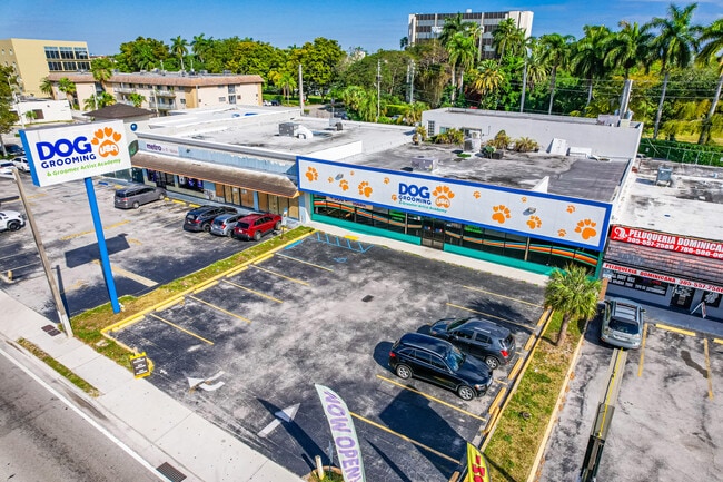
Property Record
1415 W 49Th St, Hialeah, FL 33012

Current Lease Availabilities
Property Detail
1415 W 49Th St
04-3002-000-0021
2 53 40 .34 AC BEG 1285.07FTW OF E/L SEC 2 & N/L OF 103 ST FOR POB W75FT N208.60FT SELY78.81FT TO PC THE ALG ARC OF CURVE 1.33FT TH S181.40FT TO POB LOT SIZE 14625 SQUARE FEET OR 13047-318 1086 1 COC 23327-3440 04 2005 4
Storemultistory
Miami-Dade
6400
Florida
B and X Area of moderate flood hazard, usually the area between the limits of the 100-year and 500-year floods.
0.34 AC
2024
Hialeah
2025
South Florida
000718
Miami-Miami Beach-Kendall, FL
5,634 SF
NEARBY LISTINGS FOR SALE OR LEASE
DEMOGRAPHICS near 1415 W 49Th St
1 mile
3 mile
5 mile
2025 Total Population
40,802
207,081
450,404
2030 Population
43,506
219,684
480,580
Pop Growth 2025-2030
+ 6.63%
+ 6.09%
+ 6.70%
Average Age
46
44
42
2025 Total Households
14,818
69,069
149,527
HH Growth 2025-2030
+ 6.64%
+ 6.02%
+ 6.65%
Median Household Inc
$45,272
$56,290
$67,103
Avg Household Size
2.70
2.90
2.90
2025 Avg HH Vehicles
2.00
2.00
2.00
Median Home Value
$344,083
$406,757
$444,177
Median Year Built
1975
1975
1980
Nearby Places
Map Layers
Map Styles
 Street
 Aerial
Layers
 Traffic
 Biking
Places
Listings with unknown addresses are not visible on the map
- Restaurants
- Banks
- Shops
- Fitness
- Groceries
PUBLIC TRANSPORTATION
COMMUTER RAIL
Okeechobee (Metrorail Green Line - Miami-Dade Transit (Metrorail/Metromover))
Drive
Walk
Distance
Okeechobee (Metrorail Green Line - Miami-Dade Transit (Metrorail/Metromover))
6 min
2.6 mi
Palmetto (Metrorail Green Line - Miami-Dade Transit (Metrorail/Metromover))
Drive
Walk
Distance
Palmetto (Metrorail Green Line - Miami-Dade Transit (Metrorail/Metromover))
6 min
2.9 mi
AIRPORT
Miami International
Drive
Walk
Distance
Miami International
16 min
6.9 mi
Fort Lauderdale/Hollywood International
Drive
Walk
Distance
Fort Lauderdale/Hollywood International
36 min
21.5 mi
Freight Ports
Port of Miami
Drive
Walk
Distance
Port of Miami
27 min
13.5 mi
Nearby Properties
Address
Land Use
TOTAL SIZE
Lot Size
Zoning
Address
Land Use
TOTAL SIZE
Lot Size
Zoning
614,708 SF
22.54 AC
4400
Address
Land Use
TOTAL SIZE
Lot Size
Zoning
636,721 SF
52.61 AC
2800
Address
Land Use
TOTAL SIZE
Lot Size
Zoning
7.62 AC
7200
Address
Land Use
TOTAL SIZE
Lot Size
Zoning
510,395 SF
28.32 AC
6500
Address
Land Use
TOTAL SIZE
Lot Size
Zoning
439,520 SF
20.20 AC
9400
Address
Land Use
TOTAL SIZE
Lot Size
Zoning
301,593 SF
16 AC
7100
Address
Land Use
TOTAL SIZE
Lot Size
Zoning
1,165,101 SF
115.84 AC
8000
Address
Land Use
TOTAL SIZE
Lot Size
Zoning
538,715 SF
24.72 AC
7100
Address
Land Use
TOTAL SIZE
Lot Size
Zoning
322,084 SF
6.60 AC
7100
Address
Land Use
TOTAL SIZE
Lot Size
Zoning
344,465 SF
5.03 AC
6400
Address
Land Use
TOTAL SIZE
Lot Size
Zoning
648,867 SF
33.08 AC
7100
Address
Land Use
TOTAL SIZE
Lot Size
Zoning
382,421 SF
19.66 AC
3700
Address
Land Use
TOTAL SIZE
Lot Size
Zoning
225,137 SF
80.89 AC
7600
Address
Land Use
TOTAL SIZE
Lot Size
Zoning
419,656 SF
8.61 AC
6400
Address
Land Use
TOTAL SIZE
Lot Size
Zoning
445,429 SF
4.45 AC
6400
Address
Land Use
TOTAL SIZE
Lot Size
Zoning
177,893 SF
15.02 AC
7100
Address
Land Use
TOTAL SIZE
Lot Size
Zoning
313,129 SF
16.06 AC
7100
Address
Land Use
TOTAL SIZE
Lot Size
Zoning
252,698 SF
13.22 AC
7100
Address
Land Use
TOTAL SIZE
Lot Size
Zoning
293,962 SF
9.99 AC
4400
Address
Land Use
TOTAL SIZE
Lot Size
Zoning
249,486 SF
11.84 AC
7100
Address
Land Use
TOTAL SIZE
Lot Size
Zoning
196,118 SF
11.06 AC
7100
Address
Land Use
TOTAL SIZE
Lot Size
Zoning
478,031 SF
1.72 AC
6600
Address
Land Use
TOTAL SIZE
Lot Size
Zoning
221,731 SF
11.17 AC
7100
Address
Land Use
TOTAL SIZE
Lot Size
Zoning
260,794 SF
12.50 AC
7100
Address
Land Use
TOTAL SIZE
Lot Size
Zoning
314,441 SF
16.99 AC
7600
Address
Land Use
TOTAL SIZE
Lot Size
Zoning
261,263 SF
9.22 AC
6109
Address
Land Use
TOTAL SIZE
Lot Size
Zoning
366,063 SF
57.35 AC
7100
Address
Land Use
TOTAL SIZE
Lot Size
Zoning
330,082 SF
7.02 AC
8000
Address
Land Use
TOTAL SIZE
Lot Size
Zoning
268,232 SF
14.33 AC
7100
Address
Land Use
TOTAL SIZE
Lot Size
Zoning
335,221 SF
21.51 AC
6400
The World's #1 Commercial Real Estate Marketplace
Connect with us
© 2026 CoStar Group
The information above has been obtained from sources believed reliable. While we do not doubt its accuracy we have not verified it and make no guarantee, warranty or representation about it. It is your responsibility to independently confirm its accuracy and completeness. Any projections, opinions, assumptions, or estimates used are for example only and do not represent the current or future performance of the property. The value of this transaction to you depends on tax and other factors which should be evaluated by your tax, financial, and legal advisors. You and your advisors should conduct a careful, independent investigation of the property to determine to your satisfaction the suitability of the property for your needs.