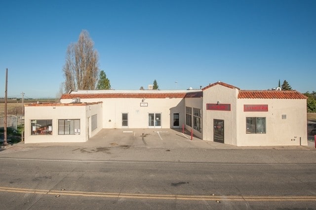
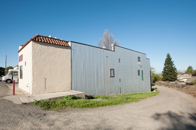
Property Record
14164 River Rd, Walnut Grove, CA 95690
NEARBY LISTINGS FOR SALE OR LEASE
Property Detail
14164 River Rd
Sacramento-Roseville-Folsom, CA
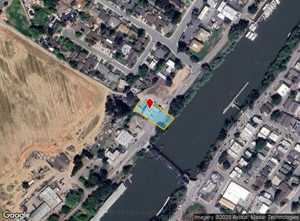
Parcel Map
142-0080-076
PARCEL MAP, LOT A
Storebuilding
Sacramento
AE
California
06067C0560H
a
2024
0.44 AC
2025
Outer Sacramento Cnty
009900
Sacramento
5,583 SF
DEMOGRAPHICS near 14164 River Rd
1 mile
3 mile
5 mile
2024 Total Population
1,127
1,769
2,214
2029 Population
1,056
1,681
2,111
Pop Growth 2024-2029
(6.30%)
(4.97%)
(4.65%)
Average Age
42
42
42
2024 Total Households
417
650
799
HH Growth 2024-2029
(6.47%)
(5.08%)
(4.88%)
Median Household Inc
$64,807
$64,473
$64,246
Avg Household Size
2.60
2.60
2.70
2024 Avg HH Vehicles
2.00
2.00
2.00
Median Home Value
$707,848
$683,139
$676,710
Median Year Built
1957
1964
1964
Nearby Places
Map Layers
Map Styles
 Street
 Aerial
Transit
 Traffic
 Biking
Places
Listings with unknown addresses are not visible on the map
- Restaurants
- Banks
- Shops
- Fitness
- Groceries
PUBLIC TRANSPORTATION
AIRPORT
Stockton Metro
Drive
Walk
Distance
Stockton Metro
45 min
33.9 mi
Sacramento International
Drive
Walk
Distance
Sacramento International
52 min
38.9 mi
Freight Ports
Port of Stockton
Drive
Walk
Distance
Port of Stockton
35 min
26.3 mi
SALE & LEASE HISTORY
LISTING DATE
SALE/LEASE

Sep 24, 2016
For Sale
Nearby Properties
Address
Land Use
TOTAL SIZE
Lot Size
Zoning
Address
Land Use
TOTAL SIZE
Lot Size
Zoning
9.07 AC
AG40
Address
Land Use
TOTAL SIZE
Lot Size
Zoning
1,687 SF
658.77 AC
AG40
Address
Land Use
TOTAL SIZE
Lot Size
Zoning
6,798 SF
40 AC
AG-80
Address
Land Use
TOTAL SIZE
Lot Size
Zoning
3,024 SF
159.63 AC
AG-80
Address
Land Use
TOTAL SIZE
Lot Size
Zoning
2,492 SF
214.26 AC
DW-S AG-80
Address
Land Use
TOTAL SIZE
Lot Size
Zoning
416 AC
AG40
Address
Land Use
TOTAL SIZE
Lot Size
Zoning
4,623 SF
2.27 AC
AG-80 RD-1
Address
Land Use
TOTAL SIZE
Lot Size
Zoning
6,253 SF
2.60 AC
RD-1 DW-R
Address
Land Use
TOTAL SIZE
Lot Size
Zoning
56,352 SF
9.66 AC
M-2 AG-80
Address
Land Use
TOTAL SIZE
Lot Size
Zoning
2,700 SF
91.93 AC
AG-20
Address
Land Use
TOTAL SIZE
Lot Size
Zoning
5,149 SF
4.48 AC
AR-1 RD-1
Address
Land Use
TOTAL SIZE
Lot Size
Zoning
5,744 SF
1.98 AC
DW RD-1 AG
Address
Land Use
TOTAL SIZE
Lot Size
Zoning
2,631 SF
3.76 AC
AG-80 RD-1
Address
Land Use
TOTAL SIZE
Lot Size
Zoning
768.22 AC
AG-80
Address
Land Use
TOTAL SIZE
Lot Size
Zoning
4,527 SF
2.77 AC
AG-80 RD-1
Address
Land Use
TOTAL SIZE
Lot Size
Zoning
720.47 AC
AG-80
Address
Land Use
TOTAL SIZE
Lot Size
Zoning
4,487 SF
1.83 AC
RD-1 DW-R
Address
Land Use
TOTAL SIZE
Lot Size
Zoning
4,212 SF
127.77 AC
O AG-80
Address
Land Use
TOTAL SIZE
Lot Size
Zoning
4,136 SF
24.32 AC
AG-20
Address
Land Use
TOTAL SIZE
Lot Size
Zoning
936 SF
120.76 AC
AG-80
Address
Land Use
TOTAL SIZE
Lot Size
Zoning
4.52 AC
M-2
Address
Land Use
TOTAL SIZE
Lot Size
Zoning
4.29 AC
DW AG-40
Address
Land Use
TOTAL SIZE
Lot Size
Zoning
3,536 SF
1.72 AC
RD-1 DW
Address
Land Use
TOTAL SIZE
Lot Size
Zoning
121.84 AC
AG-80
Address
Land Use
TOTAL SIZE
Lot Size
Zoning
4,182 SF
2.22 AC
AG-80 RD-1
Address
Land Use
TOTAL SIZE
Lot Size
Zoning
1,548 SF
39.45 AC
AG-20
Address
Land Use
TOTAL SIZE
Lot Size
Zoning
2,939 SF
90 AC
AG-80
Address
Land Use
TOTAL SIZE
Lot Size
Zoning
1,131 SF
82.97 AC
AG40
Address
Land Use
TOTAL SIZE
Lot Size
Zoning
512 SF
4.03 AC
AG40
Address
Land Use
TOTAL SIZE
Lot Size
Zoning
40 AC
AG-40 LC
The World's #1 Commercial Real Estate Marketplace
Connect with us
© 2026 CoStar Group
The information above has been obtained from sources believed reliable. While we do not doubt its accuracy we have not verified it and make no guarantee, warranty or representation about it. It is your responsibility to independently confirm its accuracy and completeness. Any projections, opinions, assumptions, or estimates used are for example only and do not represent the current or future performance of the property. The value of this transaction to you depends on tax and other factors which should be evaluated by your tax, financial, and legal advisors. You and your advisors should conduct a careful, independent investigation of the property to determine to your satisfaction the suitability of the property for your needs.