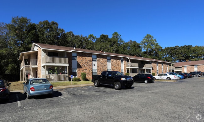
Property Record
1417 Azalea Rd, Mobile, AL 36693


Save to a Folder
{{folder.Name}}
{{folder.ListingIds.length}} Properties
{{folder.ListingIds.length}} Property
Create a New Folder
Property Detail
1417 Azalea Rd
33-01-12-2-000-003
COM AT NE COR OF NW 1/4 OF SW 1/4 OF SEC 1 T5S R2W TH S 00 DEG 07 MIN W A DIST OF 2642.34 FT TH RUN E A DIS OF 296.45 FT TO
Apartment
Mobile
C and X Area of minimal flood hazard, usually depicted on FIRMs as above the 500-year flood level.
Alabama
2025
15.69 AC
2025
Spring Valley
003000
Mobile
18,392 SF
Mobile, AL
NEARBY LISTINGS FOR SALE OR LEASE
-
-
View all Mobile listings for sale on LoopNet.com
DEMOGRAPHICS near 1417 Azalea Rd
1 mile
3 mile
5 mile
2025 Total Population
2,633
43,184
129,977
2030 Population
2,581
42,593
129,142
Pop Growth 2025-2030
(1.97%)
(1.37%)
(0.64%)
Average Age
42
40
39
2025 Total Households
1,117
17,688
54,246
HH Growth 2025-2030
(1.97%)
(1.44%)
(0.79%)
Median Household Inc
$44,746
$53,297
$53,787
Avg Household Size
2.30
2.40
2.30
2025 Avg HH Vehicles
2.00
2.00
2.00
Median Home Value
$229,737
$186,116
$206,802
Median Year Built
1976
1974
1975
Nearby Places
Map Layers
Map Styles
 Street
 Aerial
Layers
 Traffic
 Biking
Places
Listings with unknown addresses are not visible on the map
- Restaurants
- Banks
- Shops
- Fitness
- Groceries
PUBLIC TRANSPORTATION
AIRPORT
Mobile International
Drive
Walk
Distance
Mobile International
13 min
7.6 mi
Mobile Regional
Drive
Walk
Distance
Mobile Regional
26 min
12.7 mi
Freight Ports
Port of Mobile
Drive
Walk
Distance
Port of Mobile
16 min
10.9 mi
Nearby Properties
Address
Land Use
TOTAL SIZE
Lot Size
Zoning
Address
Land Use
TOTAL SIZE
Lot Size
Zoning
85,823 SF
13.26 AC
Address
Land Use
TOTAL SIZE
Lot Size
Zoning
194,016 SF
10.74 AC
Address
Land Use
TOTAL SIZE
Lot Size
Zoning
30,972 SF
4.75 AC
Address
Land Use
TOTAL SIZE
Lot Size
Zoning
24,255 SF
9.15 AC
Address
Land Use
TOTAL SIZE
Lot Size
Zoning
34,200 SF
30.03 AC
Address
Land Use
TOTAL SIZE
Lot Size
Zoning
37,604 SF
9.10 AC
Address
Land Use
TOTAL SIZE
Lot Size
Zoning
29,448 SF
7.64 AC
Address
Land Use
TOTAL SIZE
Lot Size
Zoning
150,800 SF
15.39 AC
Address
Land Use
TOTAL SIZE
Lot Size
Zoning
16,584 SF
15.25 AC
Address
Land Use
TOTAL SIZE
Lot Size
Zoning
45,648 SF
6.32 AC
Address
Land Use
TOTAL SIZE
Lot Size
Zoning
131,480 SF
21 AC
Address
Land Use
TOTAL SIZE
Lot Size
Zoning
50,582 SF
4.39 AC
Address
Land Use
TOTAL SIZE
Lot Size
Zoning
15,120 SF
10.26 AC
Address
Land Use
TOTAL SIZE
Lot Size
Zoning
121,404 SF
41.25 AC
Address
Land Use
TOTAL SIZE
Lot Size
Zoning
51,610 SF
16.89 AC
Address
Land Use
TOTAL SIZE
Lot Size
Zoning
118,169 SF
8.33 AC
Address
Land Use
TOTAL SIZE
Lot Size
Zoning
15,476 SF
10.44 AC
Address
Land Use
TOTAL SIZE
Lot Size
Zoning
34,050 SF
9.67 AC
Address
Land Use
TOTAL SIZE
Lot Size
Zoning
15,192 SF
7.40 AC
Address
Land Use
TOTAL SIZE
Lot Size
Zoning
92,329 SF
14.68 AC
Address
Land Use
TOTAL SIZE
Lot Size
Zoning
64,667 SF
1.92 AC
Address
Land Use
TOTAL SIZE
Lot Size
Zoning
36,207 SF
15.96 AC
Address
Land Use
TOTAL SIZE
Lot Size
Zoning
20,000 SF
28.80 AC
Address
Land Use
TOTAL SIZE
Lot Size
Zoning
139,097 SF
11.64 AC
Address
Land Use
TOTAL SIZE
Lot Size
Zoning
13,160 SF
7.96 AC
Address
Land Use
TOTAL SIZE
Lot Size
Zoning
103,831 SF
19.36 AC
Address
Land Use
TOTAL SIZE
Lot Size
Zoning
29,106 SF
4.99 AC
Address
Land Use
TOTAL SIZE
Lot Size
Zoning
92,708 SF
3.06 AC
Address
Land Use
TOTAL SIZE
Lot Size
Zoning
42,790 SF
1.98 AC
The World's #1 Commercial Real Estate Marketplace
Connect with us
© 2026 CoStar Group
The information above has been obtained from sources believed reliable. While we do not doubt its accuracy we have not verified it and make no guarantee, warranty or representation about it. It is your responsibility to independently confirm its accuracy and completeness. Any projections, opinions, assumptions, or estimates used are for example only and do not represent the current or future performance of the property. The value of this transaction to you depends on tax and other factors which should be evaluated by your tax, financial, and legal advisors. You and your advisors should conduct a careful, independent investigation of the property to determine to your satisfaction the suitability of the property for your needs.