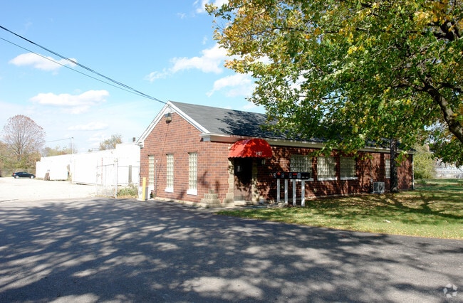
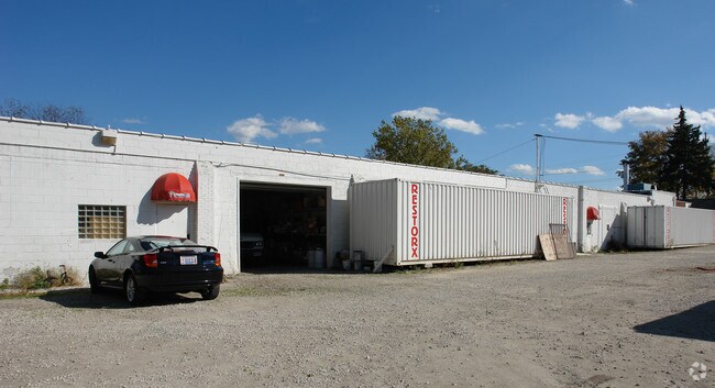
Property Record
1417 E Archwood Ave, Akron, OH 44306

Property Detail
1417 E Archwood Ave
Akron, OH
TR 2 LOT 2 N OF ARCHWOOD 2.020A
67-33278
SUMMIT
Warehouse
Ohio
B and X Area of moderate flood hazard, usually the area between the limits of the 100-year and 500-year floods.
2
2025
1.70 AC
2026
Akron
503500
Cleveland
8,846 SF
NEARBY LISTINGS FOR SALE OR LEASE
DEMOGRAPHICS near 1417 E Archwood Ave
1 mile
3 mile
5 mile
2025 Total Population
7,863
85,193
192,792
2030 Population
7,934
85,662
193,622
Pop Growth 2025-2030
+ 0.90%
+ 0.55%
+ 0.43%
Average Age
38
38
40
2025 Total Households
3,350
35,898
81,976
HH Growth 2025-2030
+ 0.84%
+ 0.50%
+ 0.40%
Median Household Inc
$39,953
$49,478
$49,330
Avg Household Size
2.30
2.20
2.20
2025 Avg HH Vehicles
1.00
2.00
2.00
Median Home Value
$92,041
$119,493
$136,205
Median Year Built
1959
1953
1955
Nearby Places
Map Layers
Map Styles
 Street
 Aerial
Layers
 Traffic
 Biking
Places
Listings with unknown addresses are not visible on the map
- Restaurants
- Banks
- Shops
- Fitness
- Groceries
PUBLIC TRANSPORTATION
COMMUTER RAIL
Akron Northside (National Park Scenic Railway - Cuyahoga Valley Scenic Railroad)
Drive
Walk
Distance
Akron Northside (National Park Scenic Railway - Cuyahoga Valley Scenic Railroad)
10 min
5.0 mi
Big Bend (National Park Scenic Railway - Cuyahoga Valley Scenic Railroad)
Drive
Walk
Distance
Big Bend (National Park Scenic Railway - Cuyahoga Valley Scenic Railroad)
18 min
8.3 mi
AIRPORT
Akron-Canton Regional
Drive
Walk
Distance
Akron-Canton Regional
18 min
12.4 mi
Freight Ports
Port of Toledo
Drive
Walk
Distance
Port of Toledo
165 min
139.3 mi
Nearby Properties
Address
Land Use
TOTAL SIZE
Lot Size
Zoning
Address
Land Use
TOTAL SIZE
Lot Size
Zoning
1,811,279 SF
38.71 AC
Address
Land Use
TOTAL SIZE
Lot Size
Zoning
184.01 AC
Address
Land Use
TOTAL SIZE
Lot Size
Zoning
225,751 SF
0.16 AC
Address
Land Use
TOTAL SIZE
Lot Size
Zoning
404,207 SF
2.19 AC
Address
Land Use
TOTAL SIZE
Lot Size
Zoning
203,458 SF
10.41 AC
Address
Land Use
TOTAL SIZE
Lot Size
Zoning
264,753 SF
22.87 AC
Address
Land Use
TOTAL SIZE
Lot Size
Zoning
9.19 AC
Address
Land Use
TOTAL SIZE
Lot Size
Zoning
56.06 AC
Address
Land Use
TOTAL SIZE
Lot Size
Zoning
23.26 AC
Address
Land Use
TOTAL SIZE
Lot Size
Zoning
423,125 SF
5.57 AC
Address
Land Use
TOTAL SIZE
Lot Size
Zoning
Address
Land Use
TOTAL SIZE
Lot Size
Zoning
57,369 SF
93.97 AC
Address
Land Use
TOTAL SIZE
Lot Size
Zoning
183,227 SF
4.29 AC
Address
Land Use
TOTAL SIZE
Lot Size
Zoning
347,139 SF
9.65 AC
Address
Land Use
TOTAL SIZE
Lot Size
Zoning
3.16 AC
Address
Land Use
TOTAL SIZE
Lot Size
Zoning
66,302 SF
10.87 AC
Address
Land Use
TOTAL SIZE
Lot Size
Zoning
52,803 SF
1.33 AC
Address
Land Use
TOTAL SIZE
Lot Size
Zoning
232,791 SF
8.16 AC
Address
Land Use
TOTAL SIZE
Lot Size
Zoning
245,911 SF
14.48 AC
Address
Land Use
TOTAL SIZE
Lot Size
Zoning
142,848 SF
13.85 AC
Address
Land Use
TOTAL SIZE
Lot Size
Zoning
52,949 SF
2.35 AC
Address
Land Use
TOTAL SIZE
Lot Size
Zoning
248,793 SF
0.27 AC
Address
Land Use
TOTAL SIZE
Lot Size
Zoning
154,926 SF
12.38 AC
Address
Land Use
TOTAL SIZE
Lot Size
Zoning
89,642 SF
0.69 AC
Address
Land Use
TOTAL SIZE
Lot Size
Zoning
196,767 SF
37.16 AC
Address
Land Use
TOTAL SIZE
Lot Size
Zoning
99,003 SF
20.10 AC
Address
Land Use
TOTAL SIZE
Lot Size
Zoning
639,478 SF
29.51 AC
Address
Land Use
TOTAL SIZE
Lot Size
Zoning
33.14 AC
Address
Land Use
TOTAL SIZE
Lot Size
Zoning
154,690 SF
4.13 AC
Address
Land Use
TOTAL SIZE
Lot Size
Zoning
270,860 SF
131.89 AC
The World's #1 Commercial Real Estate Marketplace
Connect with us
© 2026 CoStar Group
The information above has been obtained from sources believed reliable. While we do not doubt its accuracy we have not verified it and make no guarantee, warranty or representation about it. It is your responsibility to independently confirm its accuracy and completeness. Any projections, opinions, assumptions, or estimates used are for example only and do not represent the current or future performance of the property. The value of this transaction to you depends on tax and other factors which should be evaluated by your tax, financial, and legal advisors. You and your advisors should conduct a careful, independent investigation of the property to determine to your satisfaction the suitability of the property for your needs.