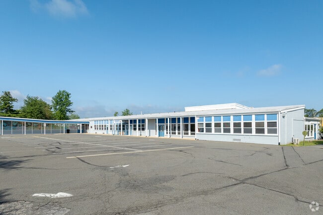
Property Record
1417 Route 179, Lambertville, NJ 08530
NEARBY LISTINGS FOR SALE OR LEASE
Property Detail
1417 Route 179
Newark, NJ-PA
FACILITY NAME: SCHOOLS
26-00005-0000-00022
Hunterdon
Publicschool
New Jersey
X
22
34019C0343F
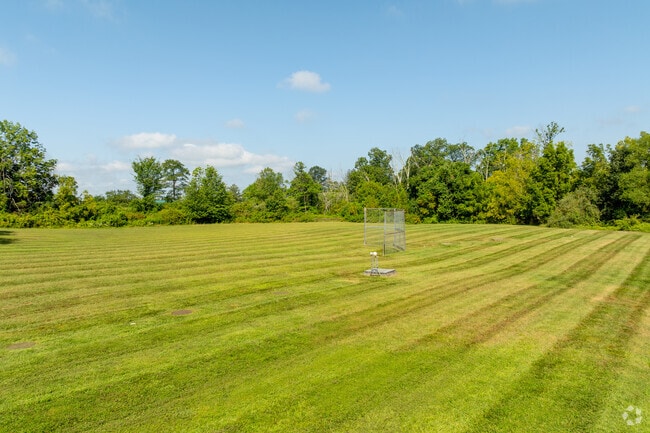
6.30 AC
2023
Hunterdon
2025
Northern New Jersey
011800
DEMOGRAPHICS near 1417 Route 179
1 Mile
3 Mile
5 Mile
2024 Total Population
490
10,636
20,817
2029 Population
508
11,006
21,264
Pop Growth 2024-2029
+ 3.67%
+ 3.48%
+ 2.15%
Average Age
44
48
48
2024 Total Households
181
4,951
8,920
HH Growth 2024-2029
+ 3.31%
+ 3.62%
+ 2.40%
Median Household Inc
$139,423
$124,344
$145,263
Avg Household Size
2.70
2.10
2.30
2024 Avg HH Vehicles
3.00
2.00
2.00
Median Home Value
$591,463
$636,901
$680,907
Median Year Built
1962
1965
1972
Nearby Places
Map Layers
Map Styles
 Street
 Aerial
- Restaurants
- Banks
- Shops
- Fitness
- Groceries
PUBLIC TRANSPORTATION
AIRPORT
Trenton Mercer
DRIVE
WALK
Distance
Trenton Mercer
25 min
14.2 mi
Freight Ports
Port of Philadelphia
DRIVE
WALK
Distance
Port of Philadelphia
57 min
32.5 mi
SALE & LEASE HISTORY
LISTING DATE
SALE/LEASE

Jul 29, 2025
For Sale
Nearby Properties
Address
Land Use
TOTAL SIZE
Lot Size
Zoning
Address
Land Use
TOTAL SIZE
Lot Size
Zoning
11.51 AC
PRD
Address
Land Use
TOTAL SIZE
Lot Size
Zoning
4 AC
PRD
Address
Land Use
TOTAL SIZE
Lot Size
Zoning
53.62 AC
RR-5
Address
Land Use
TOTAL SIZE
Lot Size
Zoning
Address
Land Use
TOTAL SIZE
Lot Size
Zoning
24,768 SF
1.47 AC
FP
Address
Land Use
TOTAL SIZE
Lot Size
Zoning
8,456 SF
2.36 AC
R-2
Address
Land Use
TOTAL SIZE
Lot Size
Zoning
7,765 SF
0.13 AC
CBD
Address
Land Use
TOTAL SIZE
Lot Size
Zoning
0.36 AC
CBD
Address
Land Use
TOTAL SIZE
Lot Size
Zoning
1,620 SF
0.23 AC
Address
Land Use
TOTAL SIZE
Lot Size
Zoning
4,924 SF
0.57 AC
CBD
Address
Land Use
TOTAL SIZE
Lot Size
Zoning
30,048 SF
22.12 AC
SRPD
Address
Land Use
TOTAL SIZE
Lot Size
Zoning
11 AC
VAL
Address
Land Use
TOTAL SIZE
Lot Size
Zoning
1,536 SF
29.11 AC
LI
Address
Land Use
TOTAL SIZE
Lot Size
Zoning
14,429 SF
2.20 AC
COM
Address
Land Use
TOTAL SIZE
Lot Size
Zoning
4,434 SF
1.47 AC
HC
Address
Land Use
TOTAL SIZE
Lot Size
Zoning
39,390 SF
1.80 AC
R-2
Address
Land Use
TOTAL SIZE
Lot Size
Zoning
540 SF
9.40 AC
LI
Address
Land Use
TOTAL SIZE
Lot Size
Zoning
100 AC
I-2
Address
Land Use
TOTAL SIZE
Lot Size
Zoning
4,200 SF
14.98 AC
HC
Address
Land Use
TOTAL SIZE
Lot Size
Zoning
4,423 SF
0.40 AC
R-2
Address
Land Use
TOTAL SIZE
Lot Size
Zoning
105.42 AC
RR-5
Address
Land Use
TOTAL SIZE
Lot Size
Zoning
3,474 SF
4.09 AC
HC
Address
Land Use
TOTAL SIZE
Lot Size
Zoning
14,331 SF
3.88 AC
HC
Address
Land Use
TOTAL SIZE
Lot Size
Zoning
24,742 SF
0.11 AC
CBD
Address
Land Use
TOTAL SIZE
Lot Size
Zoning
5,600 SF
10.99 AC
HC
Address
Land Use
TOTAL SIZE
Lot Size
Zoning
9,100 SF
5.40 AC
HC
Address
Land Use
TOTAL SIZE
Lot Size
Zoning
11,452 SF
3.95 AC
PRD
Address
Land Use
TOTAL SIZE
Lot Size
Zoning
20,505 SF
0.14 AC
CBD
Address
Land Use
TOTAL SIZE
Lot Size
Zoning
12,978 SF
2.37 AC
A-1
Address
Land Use
TOTAL SIZE
Lot Size
Zoning
8,396 SF
2 AC
RR-5
The World's #1 Commercial Real Estate Marketplace
Connect with us
© 2025 CoStar Group
The information above has been obtained from sources believed reliable. While we do not doubt its accuracy we have not verified it and make no guarantee, warranty or representation about it. It is your responsibility to independently confirm its accuracy and completeness. Any projections, opinions, assumptions, or estimates used are for example only and do not represent the current or future performance of the property. The value of this transaction to you depends on tax and other factors which should be evaluated by your tax, financial, and legal advisors. You and your advisors should conduct a careful, independent investigation of the property to determine to your satisfaction the suitability of the property for your needs.