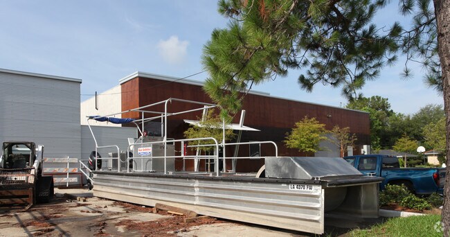
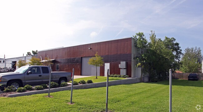
Property Record
1418 Dupas St, Gretna, LA 70053
NEARBY LISTINGS FOR SALE OR LEASE
Property Detail
1418 Dupas St
New Orleans-Metairie, LA
Oakdale
0100002307
LOT 36-A SQ 46 OAKDALE
Realpropertynec
Jefferson
X
Louisiana
22051C0220F
36a
2024
0.29 AC
2024
Westbank
025300
New Orleans/Metairie/Kenner
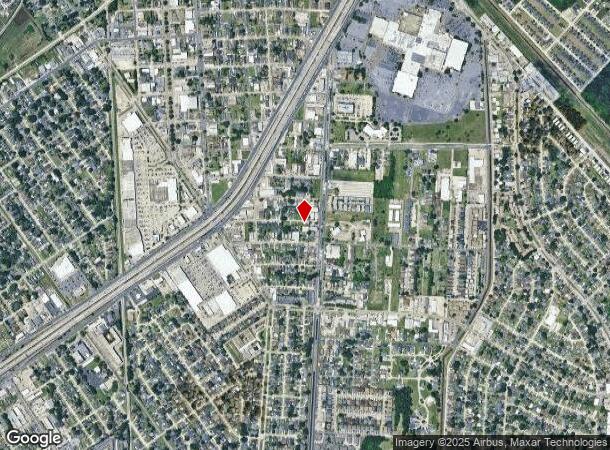
DEMOGRAPHICS near 1418 Dupas St
1 Mile
3 Mile
5 Mile
2024 Total Population
15,097
122,109
316,360
2029 Population
14,614
117,745
306,393
Pop Growth 2024-2029
(3.20%)
(3.57%)
(3.15%)
Average Age
38
40
40
2024 Total Households
6,141
51,812
136,472
HH Growth 2024-2029
(3.37%)
(3.52%)
(3.11%)
Median Household Inc
$38,711
$51,019
$51,215
Avg Household Size
2.40
2.30
2.20
2024 Avg HH Vehicles
1.00
1.00
1.00
Median Home Value
$188,151
$222,679
$242,470
Median Year Built
1970
1968
1962
Nearby Places
Map Layers
Map Styles
 Street
 Aerial
- Restaurants
- Banks
- Shops
- Fitness
- Groceries
PUBLIC TRANSPORTATION
COMMUTER RAIL
New Orleans Union Passenger Terminal (City of New Orleans - Amtrak, Crescent - Amtrak, Sunset Limited - Amtrak)
DRIVE
WALK
Distance
New Orleans Union Passenger Terminal (City of New Orleans - Amtrak, Crescent - Amtrak, Sunset Limited - Amtrak)
8 min
4.6 mi
AIRPORT
Louis Armstrong New Orleans International
DRIVE
WALK
Distance
Louis Armstrong New Orleans International
26 min
19.0 mi
Freight Ports
Port of New Orleans
DRIVE
WALK
Distance
Port of New Orleans
13 min
5.4 mi
Nearby Properties
Address
Land Use
TOTAL SIZE
Lot Size
Zoning
Address
Land Use
TOTAL SIZE
Lot Size
Zoning
44.43 AC
CBD-4
Address
Land Use
TOTAL SIZE
Lot Size
Zoning
834,043 SF
1.40 AC
CBD-2
Address
Land Use
TOTAL SIZE
Lot Size
Zoning
18.31 AC
CBD-4
Address
Land Use
TOTAL SIZE
Lot Size
Zoning
1.87 AC
CBD-2
Address
Land Use
TOTAL SIZE
Lot Size
Zoning
6.64 AC
Address
Land Use
TOTAL SIZE
Lot Size
Zoning
844,362 SF
5.85 AC
CBD-4
Address
Land Use
TOTAL SIZE
Lot Size
Zoning
0.12 AC
Address
Land Use
TOTAL SIZE
Lot Size
Zoning
30.63 AC
Address
Land Use
TOTAL SIZE
Lot Size
Zoning
444,121 SF
1.46 AC
CBD-1
Address
Land Use
TOTAL SIZE
Lot Size
Zoning
1.91 AC
CBD-1
Address
Land Use
TOTAL SIZE
Lot Size
Zoning
576,962 SF
3.31 AC
CBD-4
Address
Land Use
TOTAL SIZE
Lot Size
Zoning
1.79 AC
Address
Land Use
TOTAL SIZE
Lot Size
Zoning
512,729 SF
6.60 AC
Address
Land Use
TOTAL SIZE
Lot Size
Zoning
0.67 AC
CBD-3
Address
Land Use
TOTAL SIZE
Lot Size
Zoning
0.14 AC
Address
Land Use
TOTAL SIZE
Lot Size
Zoning
202,291 SF
4.04 AC
HU-RD2
Address
Land Use
TOTAL SIZE
Lot Size
Zoning
2.94 AC
CBD-1
Address
Land Use
TOTAL SIZE
Lot Size
Zoning
4.12 AC
Address
Land Use
TOTAL SIZE
Lot Size
Zoning
462,672 SF
1.11 AC
CBD-1
Address
Land Use
TOTAL SIZE
Lot Size
Zoning
25.26 AC
Address
Land Use
TOTAL SIZE
Lot Size
Zoning
85,568 SF
23.74 AC
MU-1
Address
Land Use
TOTAL SIZE
Lot Size
Zoning
363,470 SF
1.01 AC
CBD-2
Address
Land Use
TOTAL SIZE
Lot Size
Zoning
212,932 SF
0.58 AC
CBD-2
Address
Land Use
TOTAL SIZE
Lot Size
Zoning
714,776 SF
1.28 AC
CBD-1
Address
Land Use
TOTAL SIZE
Lot Size
Zoning
1.50 AC
CBD-1
Address
Land Use
TOTAL SIZE
Lot Size
Zoning
652,548 SF
0.68 AC
CBD-4
Address
Land Use
TOTAL SIZE
Lot Size
Zoning
50,173 SF
0.24 AC
CBD-2
Address
Land Use
TOTAL SIZE
Lot Size
Zoning
121,349 SF
0.85 AC
CBD-3
Address
Land Use
TOTAL SIZE
Lot Size
Zoning
151,320 SF
27.55 AC
Address
Land Use
TOTAL SIZE
Lot Size
Zoning
0.30 AC
CBD-5
The World's #1 Commercial Real Estate Marketplace
Connect with us
© 2025 CoStar Group
The information above has been obtained from sources believed reliable. While we do not doubt its accuracy we have not verified it and make no guarantee, warranty or representation about it. It is your responsibility to independently confirm its accuracy and completeness. Any projections, opinions, assumptions, or estimates used are for example only and do not represent the current or future performance of the property. The value of this transaction to you depends on tax and other factors which should be evaluated by your tax, financial, and legal advisors. You and your advisors should conduct a careful, independent investigation of the property to determine to your satisfaction the suitability of the property for your needs.