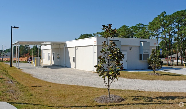
Property Record
1418 W 23Rd St, Panama City, FL 32405


NEARBY LISTINGS FOR SALE OR LEASE
Property Detail
1418 W 23Rd St
Panama City-Panama City Beach, FL
St And Bay Dev Co Plat
13200-000-000
30 3S 14W -144- MAP 91B3 ST AND BAY DEV CO PLAT COM AT THE INT OF NORTH R/W OF 23RD ST & WEST R/W OF LISENBY AVE TH RUN N ALONG LISENBY AVE 160.01 FOR POB TH CONT N 100 W 601.34 S 249 TO THE NORTH R/W OF 23ED ST TH E 11 S 6 E 63.93 N121.50 E 130 TH S
Commercialacreage
Bay
A
Florida
12005C0333J
2.48 AC
2024
Pretty Bayou
2025
Other Market Areas
001502
DEMOGRAPHICS near 1418 W 23Rd St
1 Mile
3 Mile
5 Mile
2024 Total Population
6,299
30,562
67,470
2029 Population
6,607
32,119
71,150
Pop Growth 2024-2029
+ 4.89%
+ 5.09%
+ 5.45%
Average Age
39
40
40
2024 Total Households
2,450
12,487
26,825
HH Growth 2024-2029
+ 5.39%
+ 5.57%
+ 5.94%
Median Household Inc
$62,566
$54,214
$57,327
Avg Household Size
2.40
2.30
2.40
2024 Avg HH Vehicles
2.00
2.00
2.00
Median Home Value
$208,571
$201,623
$221,592
Median Year Built
1979
1983
1985
Nearby Places
Map Layers
Map Styles
 Street
 Aerial
- Restaurants
- Banks
- Shops
- Fitness
- Groceries
PUBLIC TRANSPORTATION
AIRPORT
Northwest Florida Beaches International
DRIVE
WALK
Distance
Northwest Florida Beaches International
36 min
22.5 mi
Freight Ports
Port of Panama City
DRIVE
WALK
Distance
Port of Panama City
6 min
3.1 mi
Nearby Properties
Address
Land Use
TOTAL SIZE
Lot Size
Zoning
Address
Land Use
TOTAL SIZE
Lot Size
Zoning
477,423 SF
21.91 AC
PC09
Address
Land Use
TOTAL SIZE
Lot Size
Zoning
455,239 SF
11.87 AC
PC11
Address
Land Use
TOTAL SIZE
Lot Size
Zoning
648,279 SF
73.10 AC
PC14
Address
Land Use
TOTAL SIZE
Lot Size
Zoning
279,378 SF
13.24 AC
PC07
Address
Land Use
TOTAL SIZE
Lot Size
Zoning
503,491 SF
79.46 AC
PC12
Address
Land Use
TOTAL SIZE
Lot Size
Zoning
354,592 SF
24 AC
UND
Address
Land Use
TOTAL SIZE
Lot Size
Zoning
154,028 SF
2.01 AC
PC10
Address
Land Use
TOTAL SIZE
Lot Size
Zoning
239,259 SF
15.86 AC
UND
Address
Land Use
TOTAL SIZE
Lot Size
Zoning
214,953 SF
14.58 AC
PC09
Address
Land Use
TOTAL SIZE
Lot Size
Zoning
86,629 SF
4.70 AC
Address
Land Use
TOTAL SIZE
Lot Size
Zoning
252,630 SF
10.70 AC
Address
Land Use
TOTAL SIZE
Lot Size
Zoning
33,305 SF
15 AC
PC09
Address
Land Use
TOTAL SIZE
Lot Size
Zoning
140,899 SF
15.48 AC
PC09
Address
Land Use
TOTAL SIZE
Lot Size
Zoning
194,474 SF
16.03 AC
PC09
Address
Land Use
TOTAL SIZE
Lot Size
Zoning
115,056 SF
21 AC
PC09
Address
Land Use
TOTAL SIZE
Lot Size
Zoning
281,578 SF
21.66 AC
UND
Address
Land Use
TOTAL SIZE
Lot Size
Zoning
30,349 SF
15.70 AC
PC11
Address
Land Use
TOTAL SIZE
Lot Size
Zoning
142,051 SF
13.43 AC
PC09
Address
Land Use
TOTAL SIZE
Lot Size
Zoning
28,314 SF
6.34 AC
PC05
Address
Land Use
TOTAL SIZE
Lot Size
Zoning
122,813 SF
9.58 AC
PC09
Address
Land Use
TOTAL SIZE
Lot Size
Zoning
68,418 SF
417.69 AC
PC11
Address
Land Use
TOTAL SIZE
Lot Size
Zoning
208,296 SF
24.72 AC
PC05
Address
Land Use
TOTAL SIZE
Lot Size
Zoning
165,098 SF
9.67 AC
PC04
Address
Land Use
TOTAL SIZE
Lot Size
Zoning
164,923 SF
23.60 AC
PC09
Address
Land Use
TOTAL SIZE
Lot Size
Zoning
42,718 SF
7.77 AC
PC09
Address
Land Use
TOTAL SIZE
Lot Size
Zoning
238,930 SF
39.18 AC
PSP
Address
Land Use
TOTAL SIZE
Lot Size
Zoning
207,286 SF
3.48 AC
PC10
Address
Land Use
TOTAL SIZE
Lot Size
Zoning
81,774 SF
17.46 AC
PC05
Address
Land Use
TOTAL SIZE
Lot Size
Zoning
Address
Land Use
TOTAL SIZE
Lot Size
Zoning
The World's #1 Commercial Real Estate Marketplace
Connect with us
© 2026 CoStar Group
The information above has been obtained from sources believed reliable. While we do not doubt its accuracy we have not verified it and make no guarantee, warranty or representation about it. It is your responsibility to independently confirm its accuracy and completeness. Any projections, opinions, assumptions, or estimates used are for example only and do not represent the current or future performance of the property. The value of this transaction to you depends on tax and other factors which should be evaluated by your tax, financial, and legal advisors. You and your advisors should conduct a careful, independent investigation of the property to determine to your satisfaction the suitability of the property for your needs.