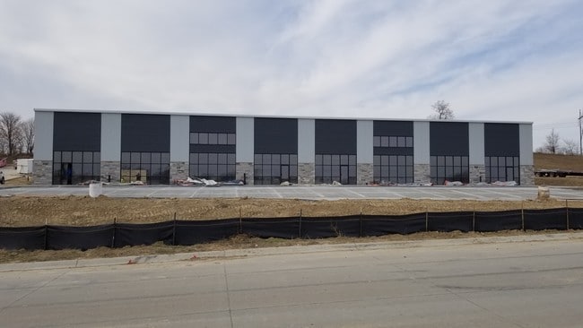
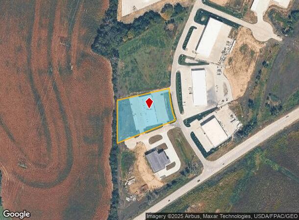
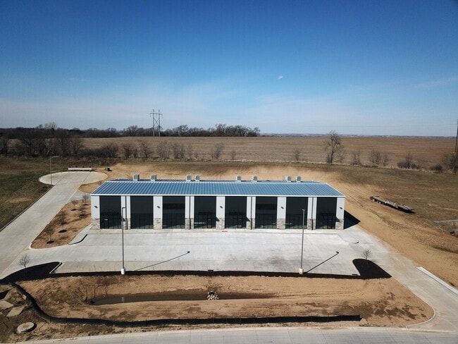
Property Record
14184 S 220Th St, Gretna, NE 68028
NEARBY LISTINGS FOR SALE OR LEASE
Property Detail
14184 S 220Th St
Omaha-Council Bluffs, NE-IA
Industrial Park North
011603086
LOT 15 NC INDUSTRIAL PARK NORTH (1.752 AC)
Industrialgeneral
Sarpy
X
Nebraska
31025C0050D
15
2024
1.75 AC
2025
Sarpy West
010701
Omaha/Council Bluffs
13,250 SF
DEMOGRAPHICS near 14184 S 220Th St
1 Mile
3 Mile
5 Mile
2024 Total Population
194
5,655
16,154
2029 Population
205
6,129
17,706
Pop Growth 2024-2029
+ 5.67%
+ 8.38%
+ 9.61%
Average Age
40
37
37
2024 Total Households
66
1,865
5,520
HH Growth 2024-2029
+ 4.55%
+ 8.47%
+ 9.75%
Median Household Inc
$121,153
$117,461
$124,534
Avg Household Size
3.00
3.00
2.90
2024 Avg HH Vehicles
3.00
3.00
2.00
Median Home Value
$462,499
$355,316
$346,369
Median Year Built
1992
2002
2004
Nearby Places
Map Layers
Map Styles
 Street
 Aerial
- Restaurants
- Banks
- Shops
- Fitness
- Groceries
PUBLIC TRANSPORTATION
AIRPORT
Eppley Airfield
DRIVE
WALK
Distance
Eppley Airfield
38 min
27.8 mi
Freight Ports
Tulsa Port Of Catoosa
DRIVE
WALK
Distance
Tulsa Port Of Catoosa
473 min
397.2 mi
SALE & LEASE HISTORY
LISTING DATE
SALE/LEASE

Nov 22, 2019
For Lease
Nov 22, 2019
For Sale
Jun 17, 2019
For Lease
Jun 17, 2019
For Sale
Nearby Properties
Address
Land Use
TOTAL SIZE
Lot Size
Zoning
Address
Land Use
TOTAL SIZE
Lot Size
Zoning
46,338 SF
25.95 AC
Address
Land Use
TOTAL SIZE
Lot Size
Zoning
30.87 AC
Address
Land Use
TOTAL SIZE
Lot Size
Zoning
1,288 SF
157.59 AC
AG
Address
Land Use
TOTAL SIZE
Lot Size
Zoning
15.85 AC
Address
Land Use
TOTAL SIZE
Lot Size
Zoning
37,589 SF
6.76 AC
Address
Land Use
TOTAL SIZE
Lot Size
Zoning
6.78 AC
Address
Land Use
TOTAL SIZE
Lot Size
Zoning
17,250 SF
10.21 AC
Address
Land Use
TOTAL SIZE
Lot Size
Zoning
1.65 AC
I1
Address
Land Use
TOTAL SIZE
Lot Size
Zoning
Address
Land Use
TOTAL SIZE
Lot Size
Zoning
5.33 AC
Address
Land Use
TOTAL SIZE
Lot Size
Zoning
32,763 SF
3 AC
Address
Land Use
TOTAL SIZE
Lot Size
Zoning
21,122 SF
3.68 AC
Address
Land Use
TOTAL SIZE
Lot Size
Zoning
3,500 SF
3.34 AC
Address
Land Use
TOTAL SIZE
Lot Size
Zoning
41,075 SF
1.04 AC
Address
Land Use
TOTAL SIZE
Lot Size
Zoning
66,758 SF
10.55 AC
I1
Address
Land Use
TOTAL SIZE
Lot Size
Zoning
11,836 SF
6.12 AC
Address
Land Use
TOTAL SIZE
Lot Size
Zoning
14,114 SF
2.80 AC
Address
Land Use
TOTAL SIZE
Lot Size
Zoning
20,400 SF
3.14 AC
Address
Land Use
TOTAL SIZE
Lot Size
Zoning
15,595 SF
12.24 AC
HC
Address
Land Use
TOTAL SIZE
Lot Size
Zoning
21,330 SF
2.14 AC
Address
Land Use
TOTAL SIZE
Lot Size
Zoning
5,624 SF
196.87 AC
AG
Address
Land Use
TOTAL SIZE
Lot Size
Zoning
3.75 AC
Address
Land Use
TOTAL SIZE
Lot Size
Zoning
6,480 SF
0.13 AC
GC
Address
Land Use
TOTAL SIZE
Lot Size
Zoning
10,500 SF
3.44 AC
I1
Address
Land Use
TOTAL SIZE
Lot Size
Zoning
0.96 AC
Address
Land Use
TOTAL SIZE
Lot Size
Zoning
35.39 AC
GC
Address
Land Use
TOTAL SIZE
Lot Size
Zoning
27,244 SF
1.97 AC
Address
Land Use
TOTAL SIZE
Lot Size
Zoning
20,000 SF
1.72 AC
Address
Land Use
TOTAL SIZE
Lot Size
Zoning
10,451 SF
2.07 AC
Address
Land Use
TOTAL SIZE
Lot Size
Zoning
9,825 SF
28.86 AC
AG
The World's #1 Commercial Real Estate Marketplace
Connect with us
© 2026 CoStar Group
The information above has been obtained from sources believed reliable. While we do not doubt its accuracy we have not verified it and make no guarantee, warranty or representation about it. It is your responsibility to independently confirm its accuracy and completeness. Any projections, opinions, assumptions, or estimates used are for example only and do not represent the current or future performance of the property. The value of this transaction to you depends on tax and other factors which should be evaluated by your tax, financial, and legal advisors. You and your advisors should conduct a careful, independent investigation of the property to determine to your satisfaction the suitability of the property for your needs.