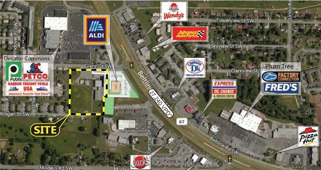
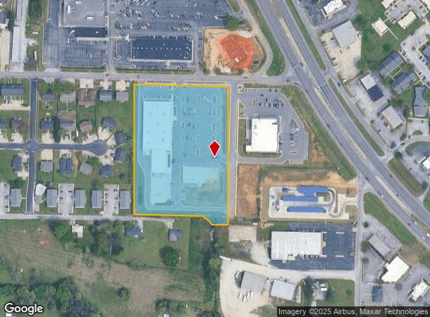
Property Record
1419 Glenn St Sw, Decatur, AL 35603
NEARBY LISTINGS FOR SALE OR LEASE
Property Detail
1419 Glenn St Sw
02-07-36-3-000-005.002
Aldi Decatur Plat No 1
Commercialnec
Morgan
X
Alabama
01103C0059F
2
2025
5.80 AC
2024
Alabama North Area
005108
Other Market Areas
13,750 SF
Decatur, AL
DEMOGRAPHICS near 1419 Glenn St Sw
1 Mile
3 Mile
5 Mile
2024 Total Population
8,797
41,640
61,624
2029 Population
8,802
41,727
61,988
Pop Growth 2024-2029
+ 0.06%
+ 0.21%
+ 0.59%
Average Age
41
39
40
2024 Total Households
3,781
17,010
24,971
HH Growth 2024-2029
+ 0.05%
+ 0.18%
+ 0.58%
Median Household Inc
$50,342
$49,318
$49,526
Avg Household Size
2.20
2.40
2.30
2024 Avg HH Vehicles
2.00
2.00
2.00
Median Home Value
$160,720
$152,228
$158,608
Median Year Built
1985
1980
1977
Nearby Places
Map Layers
Map Styles
 Street
 Aerial
- Restaurants
- Banks
- Shops
- Fitness
- Groceries
PUBLIC TRANSPORTATION
AIRPORT
Huntsville International-Carl T Jones Field
DRIVE
WALK
Distance
Huntsville International-Carl T Jones Field
32 min
20.1 mi
Freight Ports
Port of Mobile
DRIVE
WALK
Distance
Port of Mobile
369 min
335.5 mi
SALE & LEASE HISTORY
LISTING DATE
SALE/LEASE

Sep 04, 2020
For Sale
Nearby Properties
Address
Land Use
TOTAL SIZE
Lot Size
Zoning
Address
Land Use
TOTAL SIZE
Lot Size
Zoning
103,569 SF
6.69 AC
Address
Land Use
TOTAL SIZE
Lot Size
Zoning
35,727 SF
10 AC
Address
Land Use
TOTAL SIZE
Lot Size
Zoning
157,720 SF
22 AC
Address
Land Use
TOTAL SIZE
Lot Size
Zoning
48,364 SF
1.80 AC
Address
Land Use
TOTAL SIZE
Lot Size
Zoning
54,544 SF
6.53 AC
Address
Land Use
TOTAL SIZE
Lot Size
Zoning
128,239 SF
7.10 AC
Address
Land Use
TOTAL SIZE
Lot Size
Zoning
51,958 SF
14 AC
Address
Land Use
TOTAL SIZE
Lot Size
Zoning
377,685 SF
17 AC
Address
Land Use
TOTAL SIZE
Lot Size
Zoning
81,682 SF
13 AC
Address
Land Use
TOTAL SIZE
Lot Size
Zoning
205,279 SF
25.45 AC
Address
Land Use
TOTAL SIZE
Lot Size
Zoning
135,440 SF
6.76 AC
Address
Land Use
TOTAL SIZE
Lot Size
Zoning
54,352 SF
10.70 AC
Address
Land Use
TOTAL SIZE
Lot Size
Zoning
40,712 SF
12 AC
Address
Land Use
TOTAL SIZE
Lot Size
Zoning
2,546 SF
9.30 AC
Address
Land Use
TOTAL SIZE
Lot Size
Zoning
64,449 SF
12 AC
Address
Land Use
TOTAL SIZE
Lot Size
Zoning
19,239 SF
4.50 AC
Address
Land Use
TOTAL SIZE
Lot Size
Zoning
4,865 SF
22 AC
Address
Land Use
TOTAL SIZE
Lot Size
Zoning
4,181 SF
6.70 AC
Address
Land Use
TOTAL SIZE
Lot Size
Zoning
49,384 SF
1.07 AC
Address
Land Use
TOTAL SIZE
Lot Size
Zoning
81,042 SF
2.39 AC
Address
Land Use
TOTAL SIZE
Lot Size
Zoning
52,800 SF
14.50 AC
Address
Land Use
TOTAL SIZE
Lot Size
Zoning
42,197 SF
3.75 AC
Address
Land Use
TOTAL SIZE
Lot Size
Zoning
31,473 SF
2.90 AC
Address
Land Use
TOTAL SIZE
Lot Size
Zoning
19,198 SF
15 AC
Address
Land Use
TOTAL SIZE
Lot Size
Zoning
55,283 SF
4.48 AC
Address
Land Use
TOTAL SIZE
Lot Size
Zoning
175,314 SF
Address
Land Use
TOTAL SIZE
Lot Size
Zoning
33,878 SF
3.52 AC
Address
Land Use
TOTAL SIZE
Lot Size
Zoning
77,811 SF
9.34 AC
Address
Land Use
TOTAL SIZE
Lot Size
Zoning
6,800 SF
4.18 AC
The World's #1 Commercial Real Estate Marketplace
Connect with us
© 2026 CoStar Group
The information above has been obtained from sources believed reliable. While we do not doubt its accuracy we have not verified it and make no guarantee, warranty or representation about it. It is your responsibility to independently confirm its accuracy and completeness. Any projections, opinions, assumptions, or estimates used are for example only and do not represent the current or future performance of the property. The value of this transaction to you depends on tax and other factors which should be evaluated by your tax, financial, and legal advisors. You and your advisors should conduct a careful, independent investigation of the property to determine to your satisfaction the suitability of the property for your needs.