Property Record
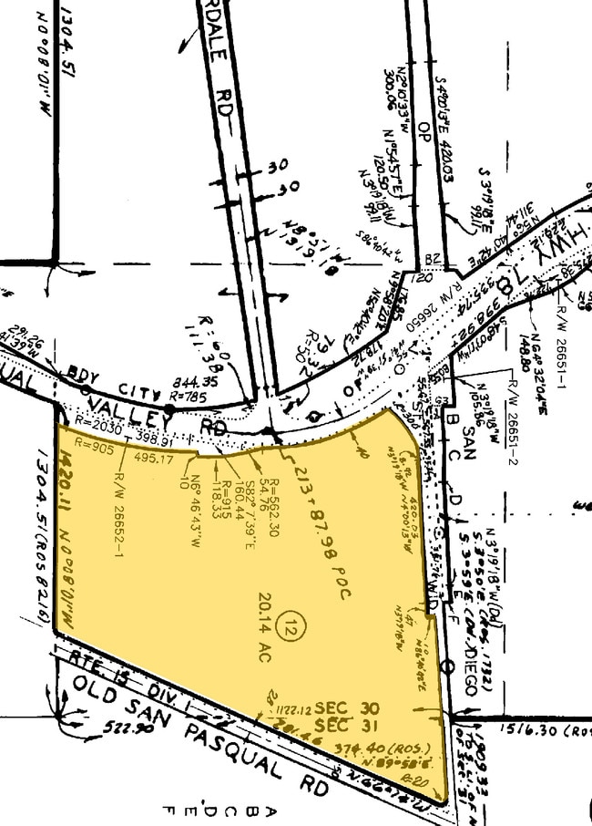
14191 San Pasqual Valley Rd, Escondido, CA 92027


NEARBY LISTINGS FOR SALE OR LEASE
Property Detail
14191 San Pasqual Valley Rd
241-081-12
SEC 30-12-1W SEQ (EX ST)DOC70-124292 IN NEQ SEC 31-12-1W&IN
Farms
San Diego
X
California
06073C1082G
20.14 AC
2024
Escondido
2025
San Diego
020209
San Diego-Carlsbad, CA
DEMOGRAPHICS near 14191 San Pasqual Valley Rd
1 Mile
3 Mile
5 Mile
2024 Total Population
620
27,407
136,616
2029 Population
609
26,997
134,796
Pop Growth 2024-2029
(1.77%)
(1.50%)
(1.33%)
Average Age
45
41
39
2024 Total Households
208
8,817
43,312
HH Growth 2024-2029
(1.92%)
(1.74%)
(1.53%)
Median Household Inc
$171,371
$116,471
$77,809
Avg Household Size
2.90
3.00
3.00
2024 Avg HH Vehicles
3.00
2.00
2.00
Median Home Value
$1,047,368
$782,408
$710,713
Median Year Built
1978
1980
1978
Nearby Places
Map Layers
Map Styles
 Street
 Aerial
- Restaurants
- Banks
- Shops
- Fitness
- Groceries
PUBLIC TRANSPORTATION
AIRPORT
San Diego International
DRIVE
WALK
Distance
San Diego International
41 min
30.6 mi
Freight Ports
Port of San Diego
DRIVE
WALK
Distance
Port of San Diego
44 min
32.8 mi
SALE & LEASE HISTORY
LISTING DATE
SALE/LEASE

Sep 24, 2016
For Sale
Oct 24, 2016
For Sale
Apr 04, 2017
For Sale
Nearby Properties
Address
Land Use
TOTAL SIZE
Lot Size
Zoning
Address
Land Use
TOTAL SIZE
Lot Size
Zoning
1.80 AC
AR-1-1
Address
Land Use
TOTAL SIZE
Lot Size
Zoning
7.60 AC
PD-C
Address
Land Use
TOTAL SIZE
Lot Size
Zoning
5.82 AC
RE-20
Address
Land Use
TOTAL SIZE
Lot Size
Zoning
Address
Land Use
TOTAL SIZE
Lot Size
Zoning
17.56 AC
RE-20
Address
Land Use
TOTAL SIZE
Lot Size
Zoning
6.08 AC
S-P
Address
Land Use
TOTAL SIZE
Lot Size
Zoning
78,067 SF
1.74 AC
PD-C
Address
Land Use
TOTAL SIZE
Lot Size
Zoning
49,132 SF
2.96 AC
R-2-12
Address
Land Use
TOTAL SIZE
Lot Size
Zoning
95,609 SF
9.17 AC
RE-20
Address
Land Use
TOTAL SIZE
Lot Size
Zoning
56,432 SF
5.40 AC
S-P
Address
Land Use
TOTAL SIZE
Lot Size
Zoning
62,960 SF
4.18 AC
R-2-12
Address
Land Use
TOTAL SIZE
Lot Size
Zoning
72,488 SF
3.73 AC
S-P
Address
Land Use
TOTAL SIZE
Lot Size
Zoning
18.79 AC
R-T/RE-20
Address
Land Use
TOTAL SIZE
Lot Size
Zoning
24,300 SF
1.82 AC
R-2-12
Address
Land Use
TOTAL SIZE
Lot Size
Zoning
24,296 SF
3.05 AC
RE-20
Address
Land Use
TOTAL SIZE
Lot Size
Zoning
66,128 SF
12.70 AC
PZ-RE-20
Address
Land Use
TOTAL SIZE
Lot Size
Zoning
23,375 SF
1.82 AC
R-2-12
Address
Land Use
TOTAL SIZE
Lot Size
Zoning
43,551 SF
3.26 AC
S-P
Address
Land Use
TOTAL SIZE
Lot Size
Zoning
3,301 SF
1.18 AC
S-P
Address
Land Use
TOTAL SIZE
Lot Size
Zoning
14,905 SF
1.02 AC
S-P
Address
Land Use
TOTAL SIZE
Lot Size
Zoning
23,928 SF
8.58 AC
RE-20
Address
Land Use
TOTAL SIZE
Lot Size
Zoning
110.92 AC
S-P
Address
Land Use
TOTAL SIZE
Lot Size
Zoning
23,910 SF
2.99 AC
R-1-10
Address
Land Use
TOTAL SIZE
Lot Size
Zoning
Address
Land Use
TOTAL SIZE
Lot Size
Zoning
13,468 SF
0.96 AC
R-2-12
Address
Land Use
TOTAL SIZE
Lot Size
Zoning
15,200 SF
0.81 AC
S-P
Address
Land Use
TOTAL SIZE
Lot Size
Zoning
11,903 SF
1.16 AC
S-P
Address
Land Use
TOTAL SIZE
Lot Size
Zoning
9,632 SF
0.84 AC
R-2-12
Address
Land Use
TOTAL SIZE
Lot Size
Zoning
9,007 SF
0.71 AC
S-P
The World's #1 Commercial Real Estate Marketplace
Connect with us
© 2025 CoStar Group
The information above has been obtained from sources believed reliable. While we do not doubt its accuracy we have not verified it and make no guarantee, warranty or representation about it. It is your responsibility to independently confirm its accuracy and completeness. Any projections, opinions, assumptions, or estimates used are for example only and do not represent the current or future performance of the property. The value of this transaction to you depends on tax and other factors which should be evaluated by your tax, financial, and legal advisors. You and your advisors should conduct a careful, independent investigation of the property to determine to your satisfaction the suitability of the property for your needs.