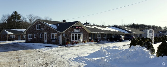
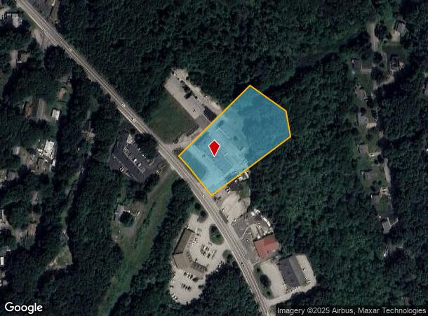
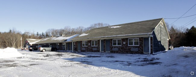
Property Record
142 Main St, Sturbridge, MA 01566
NEARBY LISTINGS FOR SALE OR LEASE
-
-
View all Sturbridge listings for sale on LoopNet.com
Property Detail
142 Main St
STUR-000415-000000-003428-000142
Sir Francis Motel Inc
Commercialnec
Worcester
X
Massachusetts
09015C0025F
3428
2025
2.16 AC
2025
Worcester
758104
Boston
10,963 SF
Worcester, MA
DEMOGRAPHICS near 142 Main St
1 Mile
3 Mile
5 Mile
2024 Total Population
1,579
22,229
31,220
2029 Population
1,568
22,127
31,106
Pop Growth 2024-2029
(0.70%)
(0.46%)
(0.37%)
Average Age
41
41
41
2024 Total Households
607
9,146
12,698
HH Growth 2024-2029
(0.66%)
(0.48%)
(0.40%)
Median Household Inc
$111,265
$62,212
$70,301
Avg Household Size
2.60
2.40
2.40
2024 Avg HH Vehicles
2.00
2.00
2.00
Median Home Value
$367,297
$305,057
$322,972
Median Year Built
1963
1957
1965
Nearby Places
Map Layers
Map Styles
 Street
 Aerial
- Restaurants
- Banks
- Shops
- Fitness
- Groceries
PUBLIC TRANSPORTATION
AIRPORT
Worcester Regional
DRIVE
WALK
Distance
Worcester Regional
38 min
20.2 mi
Bradley International
DRIVE
WALK
Distance
Bradley International
74 min
43.4 mi
Freight Ports
Port of Davisville, RI
DRIVE
WALK
Distance
Port of Davisville, RI
93 min
67.4 mi
Nearby Properties
Address
Land Use
TOTAL SIZE
Lot Size
Zoning
Address
Land Use
TOTAL SIZE
Lot Size
Zoning
1,800 SF
10.02 AC
IG
Address
Land Use
TOTAL SIZE
Lot Size
Zoning
127,762 SF
19.28 AC
Address
Land Use
TOTAL SIZE
Lot Size
Zoning
127,620 SF
6.40 AC
R2
Address
Land Use
TOTAL SIZE
Lot Size
Zoning
45.13 AC
GB
Address
Land Use
TOTAL SIZE
Lot Size
Zoning
10.08 AC
M
Address
Land Use
TOTAL SIZE
Lot Size
Zoning
102,966 SF
30.95 AC
Address
Land Use
TOTAL SIZE
Lot Size
Zoning
Address
Land Use
TOTAL SIZE
Lot Size
Zoning
2.14 AC
CC
Address
Land Use
TOTAL SIZE
Lot Size
Zoning
93,260 SF
9.10 AC
R1
Address
Land Use
TOTAL SIZE
Lot Size
Zoning
208,444 SF
14.09 AC
Address
Land Use
TOTAL SIZE
Lot Size
Zoning
40,910 SF
25.36 AC
Address
Land Use
TOTAL SIZE
Lot Size
Zoning
76,237 SF
7.50 AC
R1
Address
Land Use
TOTAL SIZE
Lot Size
Zoning
100,771 SF
2.70 AC
R2
Address
Land Use
TOTAL SIZE
Lot Size
Zoning
Address
Land Use
TOTAL SIZE
Lot Size
Zoning
195.60 AC
IG
Address
Land Use
TOTAL SIZE
Lot Size
Zoning
4,704 SF
76 AC
Address
Land Use
TOTAL SIZE
Lot Size
Zoning
58,420 SF
5 AC
R2
Address
Land Use
TOTAL SIZE
Lot Size
Zoning
105,660 SF
Address
Land Use
TOTAL SIZE
Lot Size
Zoning
93,552 SF
40.84 AC
Address
Land Use
TOTAL SIZE
Lot Size
Zoning
89,656 SF
0.97 AC
RB
Address
Land Use
TOTAL SIZE
Lot Size
Zoning
15,000 SF
2 AC
Address
Land Use
TOTAL SIZE
Lot Size
Zoning
5,024 SF
10.60 AC
Address
Land Use
TOTAL SIZE
Lot Size
Zoning
1 AC
CC
Address
Land Use
TOTAL SIZE
Lot Size
Zoning
9.58 AC
R3
Address
Land Use
TOTAL SIZE
Lot Size
Zoning
7.86 AC
OR
Address
Land Use
TOTAL SIZE
Lot Size
Zoning
43,817 SF
3.17 AC
Address
Land Use
TOTAL SIZE
Lot Size
Zoning
10,210 SF
116.40 AC
R1
Address
Land Use
TOTAL SIZE
Lot Size
Zoning
22,204 SF
2.50 AC
CC
Address
Land Use
TOTAL SIZE
Lot Size
Zoning
56,336 SF
5 AC
GB
Address
Land Use
TOTAL SIZE
Lot Size
Zoning
55,530 SF
4.74 AC
The World's #1 Commercial Real Estate Marketplace
Connect with us
© 2026 CoStar Group
The information above has been obtained from sources believed reliable. While we do not doubt its accuracy we have not verified it and make no guarantee, warranty or representation about it. It is your responsibility to independently confirm its accuracy and completeness. Any projections, opinions, assumptions, or estimates used are for example only and do not represent the current or future performance of the property. The value of this transaction to you depends on tax and other factors which should be evaluated by your tax, financial, and legal advisors. You and your advisors should conduct a careful, independent investigation of the property to determine to your satisfaction the suitability of the property for your needs.