Property Record
142 Main St, Terryville, CT 06786
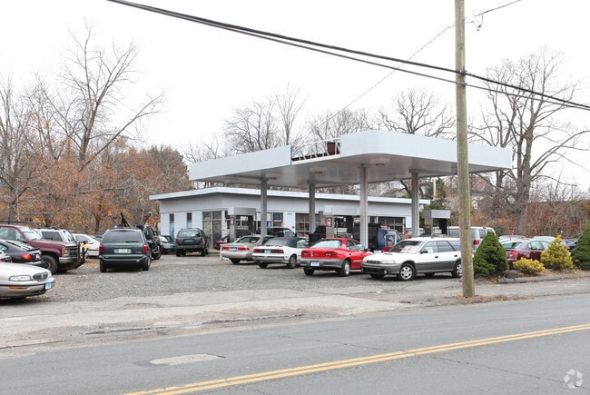

Property Detail
142 Main St
PLYM-000041-000029-000041
LITCHFIELD
Governmentalpublicusegeneral
Connecticut
C
41
2025
0.53 AC
2025
SE Litchfield County
425500
Hartford
1,860 SF
Torrington, CT
NEARBY LISTINGS FOR SALE OR LEASE
DEMOGRAPHICS near 142 Main St
1 mile
3 mile
5 mile
2025 Total Population
5,183
27,086
70,406
2030 Population
5,278
27,870
72,351
Pop Growth 2025-2030
+ 1.83%
+ 2.89%
+ 2.76%
Average Age
43
42
42
2025 Total Households
2,233
11,201
28,914
HH Growth 2025-2030
+ 1.75%
+ 2.87%
+ 2.77%
Median Household Inc
$81,147
$89,067
$85,826
Avg Household Size
2.30
2.30
2.40
2025 Avg HH Vehicles
2.00
2.00
2.00
Median Home Value
$248,192
$284,142
$289,230
Median Year Built
1958
1970
1967
Nearby Places
Map Layers
Map Styles
 Street
 Aerial
Transit
 Traffic
 Biking
Places
Listings with unknown addresses are not visible on the map
- Restaurants
- Banks
- Shops
- Fitness
- Groceries
PUBLIC TRANSPORTATION
AIRPORT
Bradley International
Drive
Walk
Distance
Bradley International
59 min
33.8 mi
Tweed/New Haven
Drive
Walk
Distance
Tweed/New Haven
53 min
36.3 mi
Freight Ports
Port of New Haven
Drive
Walk
Distance
Port of New Haven
49 min
33.9 mi
Nearby Properties
Address
Land Use
TOTAL SIZE
Lot Size
Zoning
Address
Land Use
TOTAL SIZE
Lot Size
Zoning
139 AC
IP-25
Address
Land Use
TOTAL SIZE
Lot Size
Zoning
121,917 SF
28.60 AC
R-15
Address
Land Use
TOTAL SIZE
Lot Size
Zoning
171,826 SF
36.60 AC
R-15
Address
Land Use
TOTAL SIZE
Lot Size
Zoning
169,727 SF
23.90 AC
R-25
Address
Land Use
TOTAL SIZE
Lot Size
Zoning
3.35 AC
RA2
Address
Land Use
TOTAL SIZE
Lot Size
Zoning
60,935 SF
0.92 AC
BD-1
Address
Land Use
TOTAL SIZE
Lot Size
Zoning
134,955 SF
3.30 AC
BD-2
Address
Land Use
TOTAL SIZE
Lot Size
Zoning
63,101 SF
15.50 AC
R-25
Address
Land Use
TOTAL SIZE
Lot Size
Zoning
45,377 SF
91.90 AC
R-40
Address
Land Use
TOTAL SIZE
Lot Size
Zoning
68,520 SF
2 AC
BD-1
Address
Land Use
TOTAL SIZE
Lot Size
Zoning
81,741 SF
2.76 AC
R-15/R
Address
Land Use
TOTAL SIZE
Lot Size
Zoning
49,977 SF
15.56 AC
R-25
Address
Land Use
TOTAL SIZE
Lot Size
Zoning
205,964 SF
14.35 AC
IP-3
Address
Land Use
TOTAL SIZE
Lot Size
Zoning
38,481 SF
1.98 AC
R-15/R
Address
Land Use
TOTAL SIZE
Lot Size
Zoning
18,704 SF
1.37 AC
R-15/R
Address
Land Use
TOTAL SIZE
Lot Size
Zoning
6,630 SF
2.95 AC
R-15/B
Address
Land Use
TOTAL SIZE
Lot Size
Zoning
80,861 SF
3.19 AC
BD-1
Address
Land Use
TOTAL SIZE
Lot Size
Zoning
32,380 SF
1.86 AC
R-15/B
Address
Land Use
TOTAL SIZE
Lot Size
Zoning
38,239 SF
2.20 AC
BD-1
Address
Land Use
TOTAL SIZE
Lot Size
Zoning
27,216 SF
3.80 AC
R-15/R
Address
Land Use
TOTAL SIZE
Lot Size
Zoning
2,464 SF
104.60 AC
R-40
Address
Land Use
TOTAL SIZE
Lot Size
Zoning
34.36 AC
RA2
Address
Land Use
TOTAL SIZE
Lot Size
Zoning
10 AC
RA1
Address
Land Use
TOTAL SIZE
Lot Size
Zoning
6,091 SF
5.46 AC
I
Address
Land Use
TOTAL SIZE
Lot Size
Zoning
2.77 AC
C
Address
Land Use
TOTAL SIZE
Lot Size
Zoning
206,322 SF
10.10 AC
BD-2/R
Address
Land Use
TOTAL SIZE
Lot Size
Zoning
3.99 AC
RA1
Address
Land Use
TOTAL SIZE
Lot Size
Zoning
99,750 SF
9.10 AC
IP-3
Address
Land Use
TOTAL SIZE
Lot Size
Zoning
22,938 SF
1.92 AC
M
Address
Land Use
TOTAL SIZE
Lot Size
Zoning
47,146 SF
3.34 AC
BD-2
The World's #1 Commercial Real Estate Marketplace
Connect with us
© 2026 CoStar Group
The information above has been obtained from sources believed reliable. While we do not doubt its accuracy we have not verified it and make no guarantee, warranty or representation about it. It is your responsibility to independently confirm its accuracy and completeness. Any projections, opinions, assumptions, or estimates used are for example only and do not represent the current or future performance of the property. The value of this transaction to you depends on tax and other factors which should be evaluated by your tax, financial, and legal advisors. You and your advisors should conduct a careful, independent investigation of the property to determine to your satisfaction the suitability of the property for your needs.