Property Record
142 Schofield Rd, Gilbert, SC 29054

Property Detail
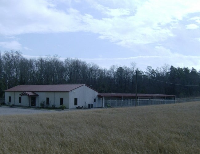
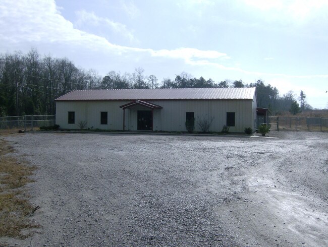
142 Schofield Rd
Kennel
Lexington
RD
South Carolina
B and X Area of moderate flood hazard, usually the area between the limits of the 100-year and 500-year floods.
8.70 AC
2025
Outlying Lexington County
2024
Columbia
021309
Columbia, SC
7,480 SF
005100-05-157
NEARBY LISTINGS FOR SALE OR LEASE
DEMOGRAPHICS near 142 Schofield Rd
1 mile
3 mile
5 mile
2025 Total Population
734
5,336
17,004
2030 Population
777
5,664
18,066
Pop Growth 2025-2030
+ 5.86%
+ 6.15%
+ 6.25%
Average Age
43
42
42
2025 Total Households
286
2,039
6,546
HH Growth 2025-2030
+ 5.94%
+ 6.28%
+ 6.43%
Median Household Inc
$101,535
$93,576
$94,535
Avg Household Size
2.60
2.60
2.60
2025 Avg HH Vehicles
3.00
3.00
2.00
Median Home Value
$285,087
$274,358
$310,258
Median Year Built
1996
1997
1998
Nearby Places
Map Layers
Map Styles
 Street
 Aerial
Layers
 Traffic
 Biking
Places
Listings with unknown addresses are not visible on the map
- Restaurants
- Banks
- Shops
- Fitness
- Groceries
PUBLIC TRANSPORTATION
AIRPORT
Columbia Metro
Drive
Walk
Distance
Columbia Metro
45 min
22.9 mi
Freight Ports
North Charleston Terminal
Drive
Walk
Distance
North Charleston Terminal
147 min
120.8 mi
Nearby Properties
Address
Land Use
TOTAL SIZE
Lot Size
Zoning
Address
Land Use
TOTAL SIZE
Lot Size
Zoning
52.36 AC
RD
Address
Land Use
TOTAL SIZE
Lot Size
Zoning
4,800 SF
9.22 AC
RD
Address
Land Use
TOTAL SIZE
Lot Size
Zoning
28,111 SF
7.01 AC
ID
Address
Land Use
TOTAL SIZE
Lot Size
Zoning
10,640 SF
1.63 AC
RD
Address
Land Use
TOTAL SIZE
Lot Size
Zoning
10,000 SF
4.98 AC
ID
Address
Land Use
TOTAL SIZE
Lot Size
Zoning
18,080 SF
7.32 AC
ID
Address
Land Use
TOTAL SIZE
Lot Size
Zoning
1,950 SF
8.90 AC
RD
Address
Land Use
TOTAL SIZE
Lot Size
Zoning
4,800 SF
2.23 AC
RD
Address
Land Use
TOTAL SIZE
Lot Size
Zoning
11,808 SF
7 AC
R
Address
Land Use
TOTAL SIZE
Lot Size
Zoning
788 SF
5 AC
ID
Address
Land Use
TOTAL SIZE
Lot Size
Zoning
10,289 SF
2.82 AC
RD
Address
Land Use
TOTAL SIZE
Lot Size
Zoning
7,000 SF
2 AC
ID
Address
Land Use
TOTAL SIZE
Lot Size
Zoning
7.21 AC
RD
Address
Land Use
TOTAL SIZE
Lot Size
Zoning
14.83 AC
RD
Address
Land Use
TOTAL SIZE
Lot Size
Zoning
9,600 SF
4.84 AC
ID
Address
Land Use
TOTAL SIZE
Lot Size
Zoning
3,400 SF
6 AC
RD
Address
Land Use
TOTAL SIZE
Lot Size
Zoning
8,000 SF
0.67 AC
ID
Address
Land Use
TOTAL SIZE
Lot Size
Zoning
1,000 SF
1.85 AC
ID
Address
Land Use
TOTAL SIZE
Lot Size
Zoning
12,480 SF
2.50 AC
ID
Address
Land Use
TOTAL SIZE
Lot Size
Zoning
3,068 SF
0.96 AC
ID
Address
Land Use
TOTAL SIZE
Lot Size
Zoning
6,725 SF
1.09 AC
RD
Address
Land Use
TOTAL SIZE
Lot Size
Zoning
5,440 SF
4 AC
C
Address
Land Use
TOTAL SIZE
Lot Size
Zoning
20.79 AC
RD
Address
Land Use
TOTAL SIZE
Lot Size
Zoning
10,400 SF
6 AC
LM
Address
Land Use
TOTAL SIZE
Lot Size
Zoning
4,800 SF
1.83 AC
LR
Address
Land Use
TOTAL SIZE
Lot Size
Zoning
6,414 SF
1.56 AC
ID
Address
Land Use
TOTAL SIZE
Lot Size
Zoning
6,498 SF
32.50 AC
RD
Address
Land Use
TOTAL SIZE
Lot Size
Zoning
2,220 SF
11.90 AC
Address
Land Use
TOTAL SIZE
Lot Size
Zoning
20.37 AC
RD
Address
Land Use
TOTAL SIZE
Lot Size
Zoning
5,194 SF
4.05 AC
ID
The World's #1 Commercial Real Estate Marketplace
Connect with us
© 2026 CoStar Group
The information above has been obtained from sources believed reliable. While we do not doubt its accuracy we have not verified it and make no guarantee, warranty or representation about it. It is your responsibility to independently confirm its accuracy and completeness. Any projections, opinions, assumptions, or estimates used are for example only and do not represent the current or future performance of the property. The value of this transaction to you depends on tax and other factors which should be evaluated by your tax, financial, and legal advisors. You and your advisors should conduct a careful, independent investigation of the property to determine to your satisfaction the suitability of the property for your needs.