Property Record
1420 Arch St, Norristown, PA 19401
NEARBY LISTINGS FOR SALE OR LEASE
Property Detail
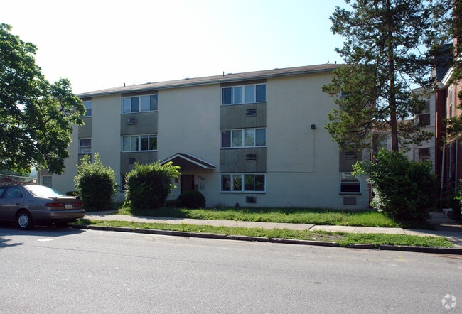
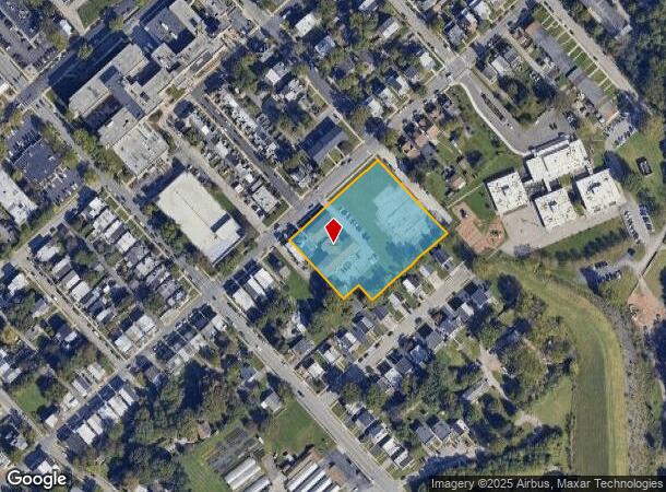
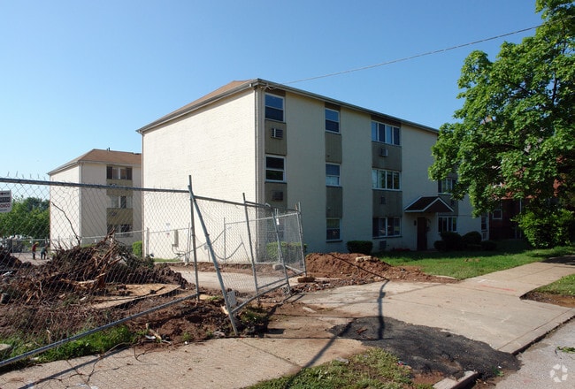
1420 Arch St
13-00-01900-004
INC B142 U1(11100 SF) & U2(15540 SF INC B142 U3(13320 SF) & 15(11647 SF 32856 SF
Apartment
Montgomery
X
Pennsylvania
42029C0120G
4
2024
1.94 AC
2025
Norristown
203500
Philadelphia
37,072 SF
Philadelphia-Camden-Wilmington, PA-NJ-DE-MD
DEMOGRAPHICS near 1420 Arch St
1 Mile
3 Mile
5 Mile
2024 Total Population
28,455
97,979
192,869
2029 Population
29,039
99,920
196,734
Pop Growth 2024-2029
+ 2.05%
+ 1.98%
+ 2.00%
Average Age
37
40
41
2024 Total Households
10,355
38,396
78,517
HH Growth 2024-2029
+ 2.11%
+ 2.05%
+ 2.10%
Median Household Inc
$51,647
$80,128
$99,011
Avg Household Size
2.50
2.40
2.40
2024 Avg HH Vehicles
1.00
2.00
2.00
Median Home Value
$189,418
$293,674
$373,053
Median Year Built
1958
1963
1971
Nearby Places
Map Layers
Map Styles
 Street
 Aerial
- Restaurants
- Banks
- Shops
- Fitness
- Groceries
PUBLIC TRANSPORTATION
TRANSIT/SUBWAY
Elm Street (Norristown) (R6 - Southeastern Pennsylvania Transportation Authority Regional Rail (SEPTA Regional Rail))
DRIVE
WALK
Distance
Elm Street (Norristown) (R6 - Southeastern Pennsylvania Transportation Authority Regional Rail (SEPTA Regional Rail))
3 min
14 min
0.8 mi
Main Street (Norristown) (R6 - Southeastern Pennsylvania Transportation Authority Regional Rail (SEPTA Regional Rail))
DRIVE
WALK
Distance
Main Street (Norristown) (R6 - Southeastern Pennsylvania Transportation Authority Regional Rail (SEPTA Regional Rail))
3 min
14 min
0.8 mi
AIRPORT
Philadelphia International
DRIVE
WALK
Distance
Philadelphia International
33 min
26.5 mi
Freight Ports
Port of Philadelphia
DRIVE
WALK
Distance
Port of Philadelphia
1 min
16.1 mi
Nearby Properties
Address
Land Use
TOTAL SIZE
Lot Size
Zoning
Address
Land Use
TOTAL SIZE
Lot Size
Zoning
1,807,465 SF
120.12 AC
R2
Address
Land Use
TOTAL SIZE
Lot Size
Zoning
365,348 SF
80.44 AC
IN
Address
Land Use
TOTAL SIZE
Lot Size
Zoning
469,066 SF
47 AC
MU
Address
Land Use
TOTAL SIZE
Lot Size
Zoning
476,392 SF
54.50 AC
I
Address
Land Use
TOTAL SIZE
Lot Size
Zoning
422,975 SF
92.05 AC
RA
Address
Land Use
TOTAL SIZE
Lot Size
Zoning
843,567 SF
50.79 AC
HI
Address
Land Use
TOTAL SIZE
Lot Size
Zoning
505,128 SF
12.11 AC
RE
Address
Land Use
TOTAL SIZE
Lot Size
Zoning
217,564 SF
12.64 AC
IN
Address
Land Use
TOTAL SIZE
Lot Size
Zoning
231,665 SF
26.34 AC
OSR
Address
Land Use
TOTAL SIZE
Lot Size
Zoning
804,184 SF
26.72 AC
HR
Address
Land Use
TOTAL SIZE
Lot Size
Zoning
381,496 SF
5.37 AC
EC
Address
Land Use
TOTAL SIZE
Lot Size
Zoning
370,404 SF
15.55 AC
SM1
Address
Land Use
TOTAL SIZE
Lot Size
Zoning
452,740 SF
11.03 AC
C
Address
Land Use
TOTAL SIZE
Lot Size
Zoning
310,900 SF
55.48 AC
HI
Address
Land Use
TOTAL SIZE
Lot Size
Zoning
320,804 SF
30.85 AC
CR
Address
Land Use
TOTAL SIZE
Lot Size
Zoning
512,846 SF
9.50 AC
HRA
Address
Land Use
TOTAL SIZE
Lot Size
Zoning
311,142 SF
39.51 AC
R1
Address
Land Use
TOTAL SIZE
Lot Size
Zoning
346,163 SF
16.53 AC
SC
Address
Land Use
TOTAL SIZE
Lot Size
Zoning
53,368 SF
38.59 AC
R3
Address
Land Use
TOTAL SIZE
Lot Size
Zoning
667,719 SF
23.73 AC
BP
Address
Land Use
TOTAL SIZE
Lot Size
Zoning
213,070 SF
29.67 AC
RE
Address
Land Use
TOTAL SIZE
Lot Size
Zoning
320,737 SF
0.98 AC
TC
Address
Land Use
TOTAL SIZE
Lot Size
Zoning
416,392 SF
26.56 AC
HR
Address
Land Use
TOTAL SIZE
Lot Size
Zoning
227,948 SF
16 AC
AR
Address
Land Use
TOTAL SIZE
Lot Size
Zoning
208,144 SF
13.91 AC
AR
Address
Land Use
TOTAL SIZE
Lot Size
Zoning
186,736 SF
5.39 AC
AR
Address
Land Use
TOTAL SIZE
Lot Size
Zoning
205,344 SF
26.67 AC
RE
Address
Land Use
TOTAL SIZE
Lot Size
Zoning
747,448 SF
36.04 AC
SC
Address
Land Use
TOTAL SIZE
Lot Size
Zoning
298,856 SF
9.58 AC
HR
Address
Land Use
TOTAL SIZE
Lot Size
Zoning
118,981 SF
4.24 AC
SM1
The World's #1 Commercial Real Estate Marketplace
Connect with us
© 2025 CoStar Group
The information above has been obtained from sources believed reliable. While we do not doubt its accuracy we have not verified it and make no guarantee, warranty or representation about it. It is your responsibility to independently confirm its accuracy and completeness. Any projections, opinions, assumptions, or estimates used are for example only and do not represent the current or future performance of the property. The value of this transaction to you depends on tax and other factors which should be evaluated by your tax, financial, and legal advisors. You and your advisors should conduct a careful, independent investigation of the property to determine to your satisfaction the suitability of the property for your needs.