Property Record
1420 Bethlehem Rd, Knightdale, NC 27545
This Property Is For Sale
NEARBY LISTINGS FOR SALE OR LEASE
Property Detail
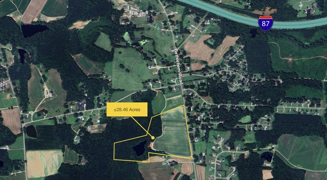
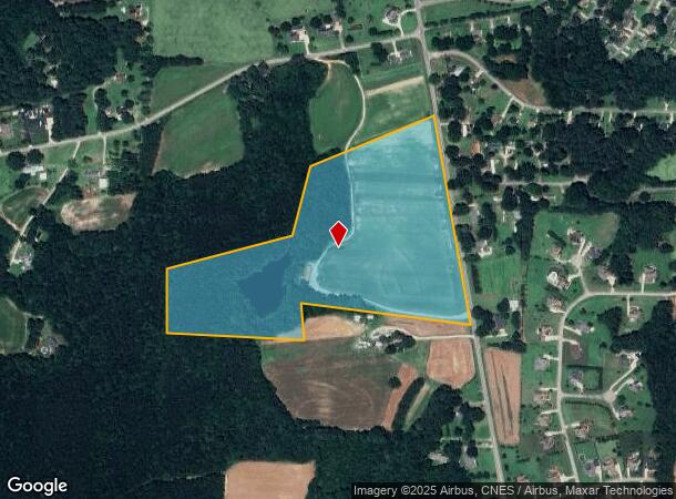
1420 Bethlehem Rd
Raleigh, NC
Exempt Plat Division B O M 2018 Pg 1537
1753.03-21-3225-000
LO2 WILKERSON & BROADWELL PROP BM2019-00
Farms
Wake
X
North Carolina
3720175300K
2
0
28.46 AC
2025
Northeast Wake County
054115
Raleigh/Durham
DEMOGRAPHICS near 1420 Bethlehem Rd
1 Mile
3 Mile
5 Mile
2024 Total Population
1,604
32,128
84,201
2029 Population
1,737
34,679
91,571
Pop Growth 2024-2029
+ 8.29%
+ 7.94%
+ 8.75%
Average Age
39
38
38
2024 Total Households
580
11,685
30,567
HH Growth 2024-2029
+ 8.62%
+ 8.37%
+ 9.18%
Median Household Inc
$68,323
$96,797
$87,895
Avg Household Size
2.80
2.70
2.70
2024 Avg HH Vehicles
2.00
2.00
2.00
Median Home Value
$324,537
$355,271
$335,451
Median Year Built
1992
2002
2003
Nearby Places
Map Layers
Map Styles
 Street
 Aerial
- Restaurants
- Banks
- Shops
- Fitness
- Groceries
PUBLIC TRANSPORTATION
AIRPORT
Raleigh-Durham International
DRIVE
WALK
Distance
Raleigh-Durham International
37 min
25.6 mi
Freight Ports
Port of Wilmington
DRIVE
WALK
Distance
Port of Wilmington
155 min
133.2 mi
Nearby Properties
Address
Land Use
TOTAL SIZE
Lot Size
Zoning
Address
Land Use
TOTAL SIZE
Lot Size
Zoning
358,360 SF
20.25 AC
HBCD
Address
Land Use
TOTAL SIZE
Lot Size
Zoning
403,802 SF
25.39 AC
RMX
Address
Land Use
TOTAL SIZE
Lot Size
Zoning
209,019 SF
5 AC
NMX P
Address
Land Use
TOTAL SIZE
Lot Size
Zoning
280,020 SF
15.44 AC
MI
Address
Land Use
TOTAL SIZE
Lot Size
Zoning
250,778 SF
16.51 AC
UR12
Address
Land Use
TOTAL SIZE
Lot Size
Zoning
240,000 SF
16.77 AC
MI
Address
Land Use
TOTAL SIZE
Lot Size
Zoning
299,965 SF
16.34 AC
RMX
Address
Land Use
TOTAL SIZE
Lot Size
Zoning
206,543 SF
19.91 AC
UR12
Address
Land Use
TOTAL SIZE
Lot Size
Zoning
204,000 SF
19.83 AC
MI CD
Address
Land Use
TOTAL SIZE
Lot Size
Zoning
155,462 SF
4.57 AC
NMX P
Address
Land Use
TOTAL SIZE
Lot Size
Zoning
159,522 SF
9.66 AC
MI
Address
Land Use
TOTAL SIZE
Lot Size
Zoning
121,658 SF
5.51 AC
NMX
Address
Land Use
TOTAL SIZE
Lot Size
Zoning
150,000 SF
7.09 AC
MI
Address
Land Use
TOTAL SIZE
Lot Size
Zoning
148,661 SF
7.80 AC
MI
Address
Land Use
TOTAL SIZE
Lot Size
Zoning
111,921 SF
8.05 AC
UR12
Address
Land Use
TOTAL SIZE
Lot Size
Zoning
84,409 SF
10.15 AC
HB
Address
Land Use
TOTAL SIZE
Lot Size
Zoning
74,000 SF
19.98 AC
UR12
Address
Land Use
TOTAL SIZE
Lot Size
Zoning
78,041 SF
7.72 AC
HB
Address
Land Use
TOTAL SIZE
Lot Size
Zoning
89,350 SF
21.48 AC
UR12
Address
Land Use
TOTAL SIZE
Lot Size
Zoning
89,196 SF
2.73 AC
NMX P
Address
Land Use
TOTAL SIZE
Lot Size
Zoning
201.30 AC
MI
Address
Land Use
TOTAL SIZE
Lot Size
Zoning
867 SF
66.88 AC
NMX
Address
Land Use
TOTAL SIZE
Lot Size
Zoning
94,680 SF
6.98 AC
MI
Address
Land Use
TOTAL SIZE
Lot Size
Zoning
135,599 SF
15.56 AC
HB
Address
Land Use
TOTAL SIZE
Lot Size
Zoning
98,493 SF
12.35 AC
HB
Address
Land Use
TOTAL SIZE
Lot Size
Zoning
52,780 SF
10.15 AC
HB
Address
Land Use
TOTAL SIZE
Lot Size
Zoning
12.50 AC
HB
Address
Land Use
TOTAL SIZE
Lot Size
Zoning
113,000 SF
7.30 AC
CU-I-
Address
Land Use
TOTAL SIZE
Lot Size
Zoning
61,677 SF
6.28 AC
HB
Address
Land Use
TOTAL SIZE
Lot Size
Zoning
52,659 SF
6.51 AC
R-30
The World's #1 Commercial Real Estate Marketplace
Connect with us
© 2025 CoStar Group
The information above has been obtained from sources believed reliable. While we do not doubt its accuracy we have not verified it and make no guarantee, warranty or representation about it. It is your responsibility to independently confirm its accuracy and completeness. Any projections, opinions, assumptions, or estimates used are for example only and do not represent the current or future performance of the property. The value of this transaction to you depends on tax and other factors which should be evaluated by your tax, financial, and legal advisors. You and your advisors should conduct a careful, independent investigation of the property to determine to your satisfaction the suitability of the property for your needs.