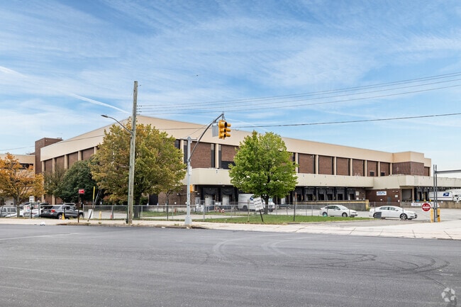
Property Record
14202 20Th Ave, Whitestone, NY 11357


Save to a Folder
{{folder.Name}}
{{folder.ListingIds.length}} Properties
{{folder.ListingIds.length}} Property
Create a New Folder
Property Detail
14202 20Th Ave
04183-0075
Queens
Uspostalservice
New York
M1-1
75
AE The base floodplain where base flood elevations are provided. AE Zones are now used on new format FIRMs instead of A1-A30 Zones.
24.61 AC
0
Northeast Queens
2026
Long Island (New York)
090700
New York-Jersey City-White Plains, NY-NJ
454,631 SF
NEARBY LISTINGS FOR SALE OR LEASE
DEMOGRAPHICS near 14202 20Th Ave
1 mile
3 mile
5 mile
2025 Total Population
51,660
418,152
1,523,379
2030 Population
50,644
409,632
1,498,518
Pop Growth 2025-2030
(1.97%)
(2.04%)
(1.63%)
Average Age
45
43
42
2025 Total Households
17,570
137,869
534,753
HH Growth 2025-2030
(2.37%)
(2.36%)
(1.90%)
Median Household Inc
$68,216
$71,099
$71,130
Avg Household Size
2.80
2.90
2.70
2025 Avg HH Vehicles
1.00
1.00
1.00
Median Home Value
$683,943
$742,580
$696,639
Median Year Built
1957
1958
1955
Nearby Places
Map Layers
Map Styles
 Street
 Aerial
Layers
 Traffic
 Biking
Places
Listings with unknown addresses are not visible on the map
- Restaurants
- Banks
- Shops
- Fitness
- Groceries
PUBLIC TRANSPORTATION
COMMUTER RAIL
Murray Hill Station (Port Washington Branch - Long Island Rail Road)
Drive
Walk
Distance
Murray Hill Station (Port Washington Branch - Long Island Rail Road)
8 min
2.6 mi
Flushing-Main Street Station (Port Washington Branch - Long Island Rail Road)
Drive
Walk
Distance
Flushing-Main Street Station (Port Washington Branch - Long Island Rail Road)
8 min
2.7 mi
AIRPORT
LaGuardia
Drive
Walk
Distance
LaGuardia
12 min
4.7 mi
John F Kennedy International
Drive
Walk
Distance
John F Kennedy International
19 min
12.3 mi
Newark Liberty International
Drive
Walk
Distance
Newark Liberty International
40 min
29.9 mi
Freight Ports
NY - Red Hook Container Terminal
Drive
Walk
Distance
NY - Red Hook Container Terminal
27 min
15.3 mi
Nearby Properties
Address
Land Use
TOTAL SIZE
Lot Size
Zoning
Address
Land Use
TOTAL SIZE
Lot Size
Zoning
23.16 AC
PARK
Address
Land Use
TOTAL SIZE
Lot Size
Zoning
2,078,606 SF
58.93 AC
R4
Address
Land Use
TOTAL SIZE
Lot Size
Zoning
1,258,350 SF
410.24 AC
PARK
Address
Land Use
TOTAL SIZE
Lot Size
Zoning
703,265 SF
83.45 AC
R4
Address
Land Use
TOTAL SIZE
Lot Size
Zoning
421,996 SF
136.05 AC
R3-1
Address
Land Use
TOTAL SIZE
Lot Size
Zoning
4,050 SF
113.40 AC
PARK
Address
Land Use
TOTAL SIZE
Lot Size
Zoning
4,800 SF
80.10 AC
PARK
Address
Land Use
TOTAL SIZE
Lot Size
Zoning
332,266 SF
12.57 AC
M2-1
Address
Land Use
TOTAL SIZE
Lot Size
Zoning
577,654 SF
5.38 AC
R6
Address
Land Use
TOTAL SIZE
Lot Size
Zoning
521,944 SF
16.68 AC
R4
Address
Land Use
TOTAL SIZE
Lot Size
Zoning
14,681 SF
97 AC
PARK
Address
Land Use
TOTAL SIZE
Lot Size
Zoning
510 SF
68.73 AC
PARK
Address
Land Use
TOTAL SIZE
Lot Size
Zoning
612,205 SF
10.08 AC
C4-4
Address
Land Use
TOTAL SIZE
Lot Size
Zoning
226,990 SF
0.72 AC
C4-3
Address
Land Use
TOTAL SIZE
Lot Size
Zoning
250,577 SF
23.17 AC
M2-1
Address
Land Use
TOTAL SIZE
Lot Size
Zoning
198,298 SF
13.93 AC
C4-1
Address
Land Use
TOTAL SIZE
Lot Size
Zoning
674,889 SF
51.55 AC
M3-1
Address
Land Use
TOTAL SIZE
Lot Size
Zoning
281,416 SF
2.57 AC
C4-2
Address
Land Use
TOTAL SIZE
Lot Size
Zoning
382,302 SF
6.23 AC
R2A
Address
Land Use
TOTAL SIZE
Lot Size
Zoning
2,828 SF
78.05 AC
PARK
Address
Land Use
TOTAL SIZE
Lot Size
Zoning
533,460 SF
27.75 AC
M1-1
Address
Land Use
TOTAL SIZE
Lot Size
Zoning
1,172,800 SF
19.66 AC
R4
Address
Land Use
TOTAL SIZE
Lot Size
Zoning
251,467 SF
2.02 AC
C4-2
Address
Land Use
TOTAL SIZE
Lot Size
Zoning
456,881 SF
1.43 AC
C4-4
Address
Land Use
TOTAL SIZE
Lot Size
Zoning
15.83 AC
M2-1
Address
Land Use
TOTAL SIZE
Lot Size
Zoning
202,063 SF
2.79 AC
C4-2
Address
Land Use
TOTAL SIZE
Lot Size
Zoning
303,039 SF
C4-2
Address
Land Use
TOTAL SIZE
Lot Size
Zoning
109,805 SF
1.96 AC
C4-2
Address
Land Use
TOTAL SIZE
Lot Size
Zoning
100,000 SF
0.69 AC
R6
The World's #1 Commercial Real Estate Marketplace
Connect with us
© 2026 CoStar Group
The information above has been obtained from sources believed reliable. While we do not doubt its accuracy we have not verified it and make no guarantee, warranty or representation about it. It is your responsibility to independently confirm its accuracy and completeness. Any projections, opinions, assumptions, or estimates used are for example only and do not represent the current or future performance of the property. The value of this transaction to you depends on tax and other factors which should be evaluated by your tax, financial, and legal advisors. You and your advisors should conduct a careful, independent investigation of the property to determine to your satisfaction the suitability of the property for your needs.