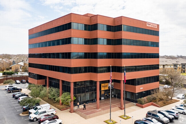
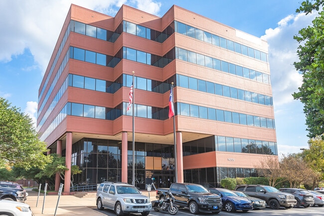
Property Record
14205 Burnet Rd, Austin, TX 78728


Current Lease Availabilities
Property Detail
14205 Burnet Rd
Austin-Round Rock-San Marcos, TX
LOT 3 BLK A WELLS BRANCH PHS A SEC 6
271366
TRAVIS
Officebuilding
Texas
B and X Area of moderate flood hazard, usually the area between the limits of the 100-year and 500-year floods.
3
2025
2.65 AC
2025
North/Domain
043000
Austin
66,976 SF
NEARBY LISTINGS FOR SALE OR LEASE
DEMOGRAPHICS near 14205 Burnet Rd
1 mile
3 mile
5 mile
2025 Total Population
11,095
87,075
299,121
2030 Population
11,528
91,061
319,146
Pop Growth 2025-2030
+ 3.90%
+ 4.58%
+ 6.69%
Average Age
38
37
37
2025 Total Households
5,460
40,838
128,062
HH Growth 2025-2030
+ 4.52%
+ 5.33%
+ 7.24%
Median Household Inc
$72,574
$80,515
$90,200
Avg Household Size
2.00
2.10
2.30
2025 Avg HH Vehicles
2.00
2.00
2.00
Median Home Value
$426,425
$466,465
$438,022
Median Year Built
1996
1998
1997
Nearby Places
Map Layers
Map Styles
 Street
 Aerial
Transit
 Traffic
 Biking
Places
Listings with unknown addresses are not visible on the map
- Restaurants
- Banks
- Shops
- Fitness
- Groceries
PUBLIC TRANSPORTATION
AIRPORT
Austin-Bergstrom International
Drive
Walk
Distance
Austin-Bergstrom International
40 min
26.1 mi
Nearby Properties
Address
Land Use
TOTAL SIZE
Lot Size
Zoning
Address
Land Use
TOTAL SIZE
Lot Size
Zoning
3,601,391 SF
159.61 AC
Address
Land Use
TOTAL SIZE
Lot Size
Zoning
830,637 SF
23.22 AC
Address
Land Use
TOTAL SIZE
Lot Size
Zoning
462,651 SF
81.77 AC
Address
Land Use
TOTAL SIZE
Lot Size
Zoning
666,331 SF
36.37 AC
Address
Land Use
TOTAL SIZE
Lot Size
Zoning
295,320 SF
2.99 AC
Address
Land Use
TOTAL SIZE
Lot Size
Zoning
293,224 SF
4.45 AC
Address
Land Use
TOTAL SIZE
Lot Size
Zoning
428,011 SF
25 AC
Address
Land Use
TOTAL SIZE
Lot Size
Zoning
381,408 SF
22.17 AC
Address
Land Use
TOTAL SIZE
Lot Size
Zoning
565,886 SF
29.30 AC
Address
Land Use
TOTAL SIZE
Lot Size
Zoning
466,256 SF
38.33 AC
Address
Land Use
TOTAL SIZE
Lot Size
Zoning
475,034 SF
26.37 AC
Address
Land Use
TOTAL SIZE
Lot Size
Zoning
284,625 SF
11.25 AC
Address
Land Use
TOTAL SIZE
Lot Size
Zoning
377,769 SF
20.97 AC
Address
Land Use
TOTAL SIZE
Lot Size
Zoning
451,564 SF
25 AC
Address
Land Use
TOTAL SIZE
Lot Size
Zoning
285,120 SF
15.60 AC
Address
Land Use
TOTAL SIZE
Lot Size
Zoning
543,958 SF
60.19 AC
Address
Land Use
TOTAL SIZE
Lot Size
Zoning
359,458 SF
18.50 AC
Address
Land Use
TOTAL SIZE
Lot Size
Zoning
349,128 SF
17.89 AC
Address
Land Use
TOTAL SIZE
Lot Size
Zoning
470,992 SF
25.92 AC
Address
Land Use
TOTAL SIZE
Lot Size
Zoning
323,284 SF
14.21 AC
Address
Land Use
TOTAL SIZE
Lot Size
Zoning
295,750 SF
21.46 AC
Address
Land Use
TOTAL SIZE
Lot Size
Zoning
290,400 SF
42.71 AC
Address
Land Use
TOTAL SIZE
Lot Size
Zoning
401,976 SF
38.07 AC
Address
Land Use
TOTAL SIZE
Lot Size
Zoning
280,279 SF
10.38 AC
Address
Land Use
TOTAL SIZE
Lot Size
Zoning
323,148 SF
20.57 AC
Address
Land Use
TOTAL SIZE
Lot Size
Zoning
477,454 SF
22.28 AC
Address
Land Use
TOTAL SIZE
Lot Size
Zoning
397,968 SF
21.69 AC
Address
Land Use
TOTAL SIZE
Lot Size
Zoning
410,378 SF
21.43 AC
Address
Land Use
TOTAL SIZE
Lot Size
Zoning
277,022 SF
14.10 AC
Address
Land Use
TOTAL SIZE
Lot Size
Zoning
313,414 SF
37.71 AC
The World's #1 Commercial Real Estate Marketplace
Connect with us
© 2026 CoStar Group
The information above has been obtained from sources believed reliable. While we do not doubt its accuracy we have not verified it and make no guarantee, warranty or representation about it. It is your responsibility to independently confirm its accuracy and completeness. Any projections, opinions, assumptions, or estimates used are for example only and do not represent the current or future performance of the property. The value of this transaction to you depends on tax and other factors which should be evaluated by your tax, financial, and legal advisors. You and your advisors should conduct a careful, independent investigation of the property to determine to your satisfaction the suitability of the property for your needs.