Property Record
14209 W Newberry Rd, Newberry, FL 32669


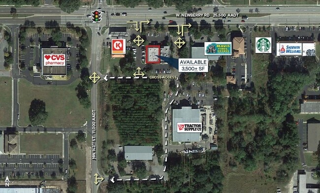

Current Lease Availabilities
NEARBY LISTINGS FOR SALE OR LEASE
-
-
View all Newberry listings for lease on LoopNet.com
Property Detail
14209 W Newberry Rd
04344-006-001
Arredondo Grant
Regionalshoppingcenterormallwithanchorstore
COM SW COR FRAC SEC N 1319.69 FT N 512.11 FT E 30.10 FT N 946.82 FT E 132 FT POB N 195.22 FT E 192.68 FT S 216.50 FT W 191.92 FT N 21.28 FT POB OR 4265/ 0595
X
Alachua
12001C0290E
Florida
2023
0.96 AC
2025
Gainesville
002202
Other Market Areas
7,000 SF
Gainesville, FL
DEMOGRAPHICS near 14209 W Newberry Rd
1 Mile
3 Mile
5 Mile
2024 Total Population
5,199
17,783
51,667
2029 Population
5,627
19,098
54,891
Pop Growth 2024-2029
+ 8.23%
+ 7.39%
+ 6.24%
Average Age
41
41
40
2024 Total Households
1,984
6,784
20,839
HH Growth 2024-2029
+ 8.37%
+ 7.55%
+ 6.30%
Median Household Inc
$98,791
$107,534
$91,839
Avg Household Size
2.60
2.60
2.40
2024 Avg HH Vehicles
2.00
2.00
2.00
Median Home Value
$327,578
$345,532
$346,575
Median Year Built
2003
2002
1995
Nearby Places
Map Layers
Map Styles
 Street
 Aerial
- Restaurants
- Banks
- Shops
- Fitness
- Groceries
PUBLIC TRANSPORTATION
AIRPORT
Gainesville Regional
DRIVE
WALK
Distance
Gainesville Regional
32 min
16.2 mi
Freight Ports
Jacksonville Port
DRIVE
WALK
Distance
Jacksonville Port
117 min
86.0 mi
Nearby Properties
Address
Land Use
TOTAL SIZE
Lot Size
Zoning
Address
Land Use
TOTAL SIZE
Lot Size
Zoning
335,387 SF
26.55 AC
R-1A
Address
Land Use
TOTAL SIZE
Lot Size
Zoning
317,776 SF
14.67 AC
PD
Address
Land Use
TOTAL SIZE
Lot Size
Zoning
101,980 SF
10.92 AC
PD
Address
Land Use
TOTAL SIZE
Lot Size
Zoning
135,060 SF
2.48 AC
PD
Address
Land Use
TOTAL SIZE
Lot Size
Zoning
198,132 SF
23.67 AC
R-2
Address
Land Use
TOTAL SIZE
Lot Size
Zoning
60,738 SF
6.69 AC
PD
Address
Land Use
TOTAL SIZE
Lot Size
Zoning
93,524 SF
4.16 AC
PD
Address
Land Use
TOTAL SIZE
Lot Size
Zoning
91,138 SF
4.57 AC
PD
Address
Land Use
TOTAL SIZE
Lot Size
Zoning
138,618 SF
8.54 AC
PD
Address
Land Use
TOTAL SIZE
Lot Size
Zoning
83,416 SF
2.34 AC
PD
Address
Land Use
TOTAL SIZE
Lot Size
Zoning
129,560 SF
19.10 AC
A
Address
Land Use
TOTAL SIZE
Lot Size
Zoning
59,688 SF
27.39 AC
R-1B
Address
Land Use
TOTAL SIZE
Lot Size
Zoning
94,700 SF
19.72 AC
PD
Address
Land Use
TOTAL SIZE
Lot Size
Zoning
26,744 SF
63.92 AC
RE-1
Address
Land Use
TOTAL SIZE
Lot Size
Zoning
10,800 SF
2.08 AC
PD
Address
Land Use
TOTAL SIZE
Lot Size
Zoning
17,548 SF
0.70 AC
PD
Address
Land Use
TOTAL SIZE
Lot Size
Zoning
60,814 SF
13.03 AC
A
Address
Land Use
TOTAL SIZE
Lot Size
Zoning
1,596 SF
58.21 AC
PD
Address
Land Use
TOTAL SIZE
Lot Size
Zoning
13,238 SF
1.57 AC
BH
Address
Land Use
TOTAL SIZE
Lot Size
Zoning
32,710 SF
22.48 AC
PD
Address
Land Use
TOTAL SIZE
Lot Size
Zoning
14,406 SF
1.61 AC
PD
Address
Land Use
TOTAL SIZE
Lot Size
Zoning
1.52 AC
R-1A
Address
Land Use
TOTAL SIZE
Lot Size
Zoning
25,484 SF
4.89 AC
PD
Address
Land Use
TOTAL SIZE
Lot Size
Zoning
38,660 SF
3.59 AC
BR
Address
Land Use
TOTAL SIZE
Lot Size
Zoning
10,800 SF
1.65 AC
BH
Address
Land Use
TOTAL SIZE
Lot Size
Zoning
18,750 SF
2.15 AC
BA
Address
Land Use
TOTAL SIZE
Lot Size
Zoning
38.22 AC
R-1A
Address
Land Use
TOTAL SIZE
Lot Size
Zoning
4,528 SF
1.73 AC
BH
Address
Land Use
TOTAL SIZE
Lot Size
Zoning
4,286 SF
0.96 AC
BH
Address
Land Use
TOTAL SIZE
Lot Size
Zoning
1.23 AC
R-1A
The World's #1 Commercial Real Estate Marketplace
Connect with us
© 2026 CoStar Group
The information above has been obtained from sources believed reliable. While we do not doubt its accuracy we have not verified it and make no guarantee, warranty or representation about it. It is your responsibility to independently confirm its accuracy and completeness. Any projections, opinions, assumptions, or estimates used are for example only and do not represent the current or future performance of the property. The value of this transaction to you depends on tax and other factors which should be evaluated by your tax, financial, and legal advisors. You and your advisors should conduct a careful, independent investigation of the property to determine to your satisfaction the suitability of the property for your needs.