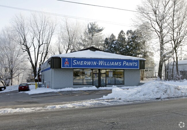
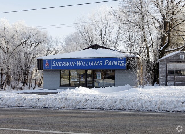
Property Record
1421 Canton Rd, Akron, OH 44312


Property Detail
1421 Canton Rd
51-05134
TR 7 NE OF CANTON RD .480A
Storebuilding
Summit
B and X Area of moderate flood hazard, usually the area between the limits of the 100-year and 500-year floods.
Ohio
2023
0.40 AC
2025
Akron
531002
Cleveland
4,048 SF
Akron, OH
NEARBY LISTINGS FOR SALE OR LEASE
DEMOGRAPHICS near 1421 Canton Rd
1 mile
3 mile
5 mile
2025 Total Population
6,262
38,684
117,661
2030 Population
6,363
38,669
117,767
Pop Growth 2025-2030
+ 1.61%
(0.04%)
+ 0.09%
Average Age
45
43
41
2025 Total Households
2,817
16,846
49,853
HH Growth 2025-2030
+ 1.63%
(0.05%)
+ 0.07%
Median Household Inc
$52,351
$63,820
$60,885
Avg Household Size
2.20
2.30
2.30
2025 Avg HH Vehicles
2.00
2.00
2.00
Median Home Value
$150,298
$158,973
$163,441
Median Year Built
1965
1961
1961
Nearby Places
Map Layers
Map Styles
 Street
 Aerial
Transit
 Traffic
 Biking
Places
Listings with unknown addresses are not visible on the map
- Restaurants
- Banks
- Shops
- Fitness
- Groceries
PUBLIC TRANSPORTATION
COMMUTER RAIL
Drive
Walk
Distance
16 min
9.4 mi
AIRPORT
Akron-Canton Regional
Drive
Walk
Distance
Akron-Canton Regional
20 min
11.3 mi
Cleveland-Hopkins International
Drive
Walk
Distance
Cleveland-Hopkins International
68 min
48.4 mi
Nearby Properties
Address
Land Use
TOTAL SIZE
Lot Size
Zoning
Address
Land Use
TOTAL SIZE
Lot Size
Zoning
162,774 SF
16.58 AC
Address
Land Use
TOTAL SIZE
Lot Size
Zoning
264,753 SF
22.87 AC
Address
Land Use
TOTAL SIZE
Lot Size
Zoning
Address
Land Use
TOTAL SIZE
Lot Size
Zoning
142,848 SF
13.85 AC
Address
Land Use
TOTAL SIZE
Lot Size
Zoning
639,478 SF
29.51 AC
Address
Land Use
TOTAL SIZE
Lot Size
Zoning
270,860 SF
131.89 AC
Address
Land Use
TOTAL SIZE
Lot Size
Zoning
115,586 SF
4.93 AC
Address
Land Use
TOTAL SIZE
Lot Size
Zoning
56,529 SF
3.67 AC
Address
Land Use
TOTAL SIZE
Lot Size
Zoning
203,059 SF
55.62 AC
Address
Land Use
TOTAL SIZE
Lot Size
Zoning
489,909 SF
23.77 AC
Address
Land Use
TOTAL SIZE
Lot Size
Zoning
882,093 SF
50.96 AC
Address
Land Use
TOTAL SIZE
Lot Size
Zoning
68,979 SF
5.07 AC
Address
Land Use
TOTAL SIZE
Lot Size
Zoning
124,939 SF
13.89 AC
Address
Land Use
TOTAL SIZE
Lot Size
Zoning
667,050 SF
24.55 AC
Address
Land Use
TOTAL SIZE
Lot Size
Zoning
187,454 SF
12.59 AC
Address
Land Use
TOTAL SIZE
Lot Size
Zoning
55,072 SF
3.41 AC
Address
Land Use
TOTAL SIZE
Lot Size
Zoning
97,454 SF
3.14 AC
Address
Land Use
TOTAL SIZE
Lot Size
Zoning
141,342 SF
6.34 AC
Address
Land Use
TOTAL SIZE
Lot Size
Zoning
329,075 SF
14.11 AC
Address
Land Use
TOTAL SIZE
Lot Size
Zoning
291,490 SF
14 AC
Address
Land Use
TOTAL SIZE
Lot Size
Zoning
212,724 SF
17.99 AC
Address
Land Use
TOTAL SIZE
Lot Size
Zoning
76,000 SF
4 AC
Address
Land Use
TOTAL SIZE
Lot Size
Zoning
248,589 SF
25.31 AC
Address
Land Use
TOTAL SIZE
Lot Size
Zoning
328,600 SF
19.36 AC
Address
Land Use
TOTAL SIZE
Lot Size
Zoning
15,248 SF
293.33 AC
Address
Land Use
TOTAL SIZE
Lot Size
Zoning
2,019 SF
31.55 AC
Address
Land Use
TOTAL SIZE
Lot Size
Zoning
410,743 SF
59.26 AC
Address
Land Use
TOTAL SIZE
Lot Size
Zoning
40.64 AC
Address
Land Use
TOTAL SIZE
Lot Size
Zoning
226,166 SF
10.62 AC
Address
Land Use
TOTAL SIZE
Lot Size
Zoning
63,934 SF
10.62 AC
The World's #1 Commercial Real Estate Marketplace
Connect with us
© 2026 CoStar Group
The information above has been obtained from sources believed reliable. While we do not doubt its accuracy we have not verified it and make no guarantee, warranty or representation about it. It is your responsibility to independently confirm its accuracy and completeness. Any projections, opinions, assumptions, or estimates used are for example only and do not represent the current or future performance of the property. The value of this transaction to you depends on tax and other factors which should be evaluated by your tax, financial, and legal advisors. You and your advisors should conduct a careful, independent investigation of the property to determine to your satisfaction the suitability of the property for your needs.