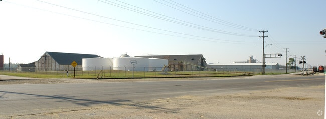
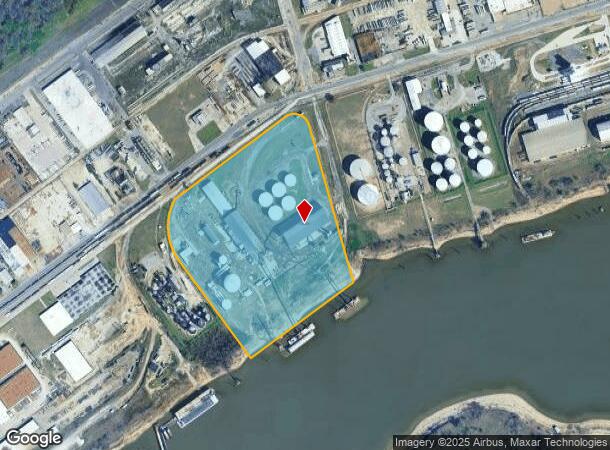
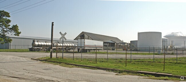
Property Record
1421 Channel Ave, Memphis, TN 38106
NEARBY LISTINGS FOR SALE OR LEASE
Property Detail
1421 Channel Ave
Memphis, TN-MS-AR
Memphis & Shelby County Port Comm Ind
05-0108-0-0008C
SS CHANNEL DR COR PORT ST (SW) CONSOL PER RICK MIDDLETON L#2708-97
Foodprocessing
Shelby
AE
Tennessee
05035C0475E
65-67
0
28.06 AC
2025
Southwest
005700
Memphis
94,284 SF
DEMOGRAPHICS near 1421 Channel Ave
1 Mile
3 Mile
5 Mile
2024 Total Population
0
14,897
77,825
2029 Population
0
15,246
78,409
Pop Growth 2024-2029
0.00%
+ 2.34%
+ 0.75%
Average Age
0
40
39
2024 Total Households
0
6,549
34,510
HH Growth 2024-2029
0.00%
+ 1.77%
+ 0.66%
Median Household Inc
$0
$28,966
$33,089
Avg Household Size
.00
2.20
2.10
2024 Avg HH Vehicles
.00
1.00
1.00
Median Home Value
$0
$82,725
$73,221
Median Year Built
0
1961
1963
Nearby Places
Map Layers
Map Styles
 Street
 Aerial
- Restaurants
- Banks
- Shops
- Fitness
- Groceries
PUBLIC TRANSPORTATION
COMMUTER RAIL
Central Station (Riverfront Loop - Memphis Area Transit Authority Trolley (MataTrolley))
DRIVE
WALK
Distance
Central Station (Riverfront Loop - Memphis Area Transit Authority Trolley (MataTrolley))
10 min
4.0 mi
AIRPORT
Memphis International
DRIVE
WALK
Distance
Memphis International
21 min
11.2 mi
Freight Ports
Port of Shreveport
DRIVE
WALK
Distance
Port of Shreveport
404 min
370.6 mi
Nearby Properties
Address
Land Use
TOTAL SIZE
Lot Size
Zoning
Address
Land Use
TOTAL SIZE
Lot Size
Zoning
438,763 SF
64.67 AC
IH
Address
Land Use
TOTAL SIZE
Lot Size
Zoning
48,729 SF
3.66 AC
BR
Address
Land Use
TOTAL SIZE
Lot Size
Zoning
62,470 SF
3.68 AC
BR
Address
Land Use
TOTAL SIZE
Lot Size
Zoning
26,952 SF
2.79 AC
BR
Address
Land Use
TOTAL SIZE
Lot Size
Zoning
342,931 SF
20.87 AC
IH
Address
Land Use
TOTAL SIZE
Lot Size
Zoning
222,777 SF
119.84 AC
IH
Address
Land Use
TOTAL SIZE
Lot Size
Zoning
127,513 SF
8.14 AC
R-R
Address
Land Use
TOTAL SIZE
Lot Size
Zoning
238,010 SF
16.58 AC
IH
Address
Land Use
TOTAL SIZE
Lot Size
Zoning
381.30 AC
R-15
Address
Land Use
TOTAL SIZE
Lot Size
Zoning
451,501 SF
21.78 AC
IH
Address
Land Use
TOTAL SIZE
Lot Size
Zoning
23,094 SF
2.92 AC
BR
Address
Land Use
TOTAL SIZE
Lot Size
Zoning
39,812 SF
1.90 AC
BR
Address
Land Use
TOTAL SIZE
Lot Size
Zoning
316,830 SF
23.55 AC
EMP
Address
Land Use
TOTAL SIZE
Lot Size
Zoning
54,000 SF
293.13 AC
IH
Address
Land Use
TOTAL SIZE
Lot Size
Zoning
24,409 SF
0.62 AC
BR
Address
Land Use
TOTAL SIZE
Lot Size
Zoning
4,000 SF
12.32 AC
IH
Address
Land Use
TOTAL SIZE
Lot Size
Zoning
5.32 AC
R-R
Address
Land Use
TOTAL SIZE
Lot Size
Zoning
65.47 AC
IH
Address
Land Use
TOTAL SIZE
Lot Size
Zoning
19,848 SF
3.61 AC
RU-3
Address
Land Use
TOTAL SIZE
Lot Size
Zoning
33,260 SF
27.33 AC
IH
Address
Land Use
TOTAL SIZE
Lot Size
Zoning
66,720 SF
7.19 AC
IH
Address
Land Use
TOTAL SIZE
Lot Size
Zoning
249,882 SF
13.11 AC
IH
Address
Land Use
TOTAL SIZE
Lot Size
Zoning
3.93 AC
R-R
Address
Land Use
TOTAL SIZE
Lot Size
Zoning
62,285 SF
6.66 AC
RU-3
Address
Land Use
TOTAL SIZE
Lot Size
Zoning
18,040 SF
1.76 AC
BR
Address
Land Use
TOTAL SIZE
Lot Size
Zoning
279,743 SF
11.91 AC
EMP
Address
Land Use
TOTAL SIZE
Lot Size
Zoning
23,650 SF
42.45 AC
IH
Address
Land Use
TOTAL SIZE
Lot Size
Zoning
225,019 SF
9.48 AC
IH
Address
Land Use
TOTAL SIZE
Lot Size
Zoning
161,402 SF
8.07 AC
IH
Address
Land Use
TOTAL SIZE
Lot Size
Zoning
3.19 AC
OS
The World's #1 Commercial Real Estate Marketplace
Connect with us
© 2026 CoStar Group
The information above has been obtained from sources believed reliable. While we do not doubt its accuracy we have not verified it and make no guarantee, warranty or representation about it. It is your responsibility to independently confirm its accuracy and completeness. Any projections, opinions, assumptions, or estimates used are for example only and do not represent the current or future performance of the property. The value of this transaction to you depends on tax and other factors which should be evaluated by your tax, financial, and legal advisors. You and your advisors should conduct a careful, independent investigation of the property to determine to your satisfaction the suitability of the property for your needs.