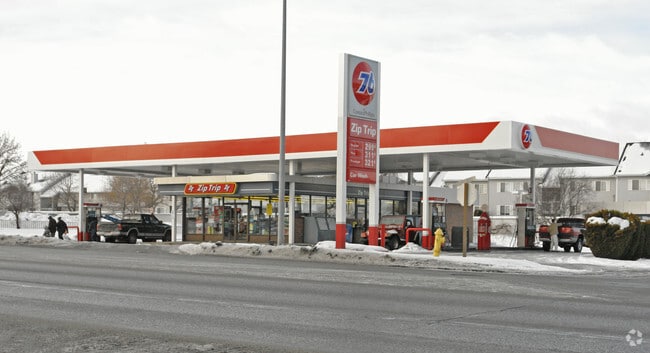
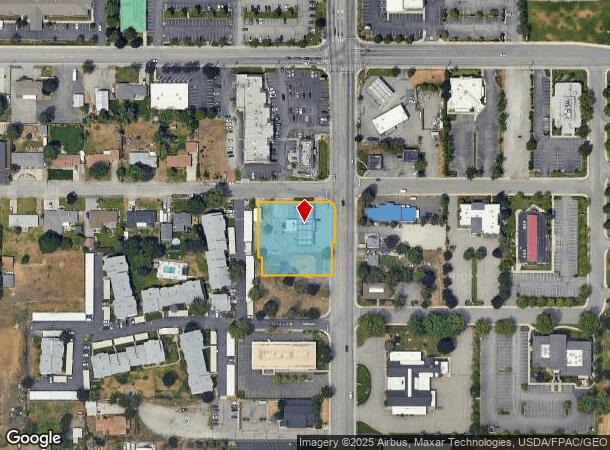
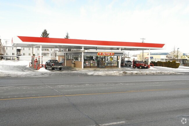
Property Record
1421 N Pines Rd, Spokane Valley, WA 99206
NEARBY LISTINGS FOR SALE OR LEASE
Property Detail
1421 N Pines Rd
Spokane-Spokane Valley, WA
Missions Pines Sub
45161.0174
EAST253.6 FT LOT1 ALSO E253.6 FT POR S2 TR#5 & S100 FT E250 FT S2 BLK5 ALSO N32.1 FT TR#36 EXC E250
Storebuilding
Spokane
X
Washington
53063C0590D
1
2025
0.88 AC
2025
Valley
011900
Spokane
2,592 SF
DEMOGRAPHICS near 1421 N Pines Rd
1 Mile
3 Mile
5 Mile
2024 Total Population
16,212
81,718
136,271
2029 Population
17,397
87,231
145,642
Pop Growth 2024-2029
+ 7.31%
+ 6.75%
+ 6.88%
Average Age
37
40
40
2024 Total Households
7,269
33,324
54,280
HH Growth 2024-2029
+ 7.50%
+ 6.90%
+ 7.03%
Median Household Inc
$46,312
$60,233
$67,452
Avg Household Size
2.10
2.40
2.40
2024 Avg HH Vehicles
2.00
2.00
2.00
Median Home Value
$285,644
$305,991
$350,135
Median Year Built
1989
1978
1983
Nearby Places
Map Layers
Map Styles
 Street
 Aerial
- Restaurants
- Banks
- Shops
- Fitness
- Groceries
PUBLIC TRANSPORTATION
COMMUTER RAIL
DRIVE
WALK
Distance
15 min
9.4 mi
AIRPORT
Spokane International
DRIVE
WALK
Distance
Spokane International
22 min
15.3 mi
Nearby Properties
Address
Land Use
TOTAL SIZE
Lot Size
Zoning
Address
Land Use
TOTAL SIZE
Lot Size
Zoning
2,818,475 SF
466.05 AC
I-2
Address
Land Use
TOTAL SIZE
Lot Size
Zoning
373,111 SF
12.44 AC
MUC
Address
Land Use
TOTAL SIZE
Lot Size
Zoning
130,380 SF
11.10 AC
MUC
Address
Land Use
TOTAL SIZE
Lot Size
Zoning
237,094 SF
58.56 AC
R-3
Address
Land Use
TOTAL SIZE
Lot Size
Zoning
3,688,247 SF
244.85 AC
I-2
Address
Land Use
TOTAL SIZE
Lot Size
Zoning
355,192 SF
35.83 AC
I-2
Address
Land Use
TOTAL SIZE
Lot Size
Zoning
169,003 SF
5.18 AC
MUC
Address
Land Use
TOTAL SIZE
Lot Size
Zoning
270,453 SF
28.62 AC
Address
Land Use
TOTAL SIZE
Lot Size
Zoning
259,169 SF
13.42 AC
MF-2
Address
Land Use
TOTAL SIZE
Lot Size
Zoning
216,965 SF
10.70 AC
MUC
Address
Land Use
TOTAL SIZE
Lot Size
Zoning
227,044 SF
7.20 AC
MUC
Address
Land Use
TOTAL SIZE
Lot Size
Zoning
318,756 SF
13.64 AC
MF-2
Address
Land Use
TOTAL SIZE
Lot Size
Zoning
323,993 SF
10.97 AC
MUC
Address
Land Use
TOTAL SIZE
Lot Size
Zoning
197,868 SF
7.15 AC
MUC
Address
Land Use
TOTAL SIZE
Lot Size
Zoning
192,698 SF
9.55 AC
MUC
Address
Land Use
TOTAL SIZE
Lot Size
Zoning
378,750 SF
17.38 AC
R-2
Address
Land Use
TOTAL SIZE
Lot Size
Zoning
346,589 SF
16.28 AC
MF-2
Address
Land Use
TOTAL SIZE
Lot Size
Zoning
204,730 SF
8.60 AC
MUC
Address
Land Use
TOTAL SIZE
Lot Size
Zoning
161,130 SF
6.45 AC
GO
Address
Land Use
TOTAL SIZE
Lot Size
Zoning
240,663 SF
8.90 AC
MF-2
Address
Land Use
TOTAL SIZE
Lot Size
Zoning
123,400 SF
4.50 AC
MUC
Address
Land Use
TOTAL SIZE
Lot Size
Zoning
84,600 SF
17.95 AC
MF-1
Address
Land Use
TOTAL SIZE
Lot Size
Zoning
136,518 SF
7.96 AC
O
Address
Land Use
TOTAL SIZE
Lot Size
Zoning
211,011 SF
8.81 AC
CMU
Address
Land Use
TOTAL SIZE
Lot Size
Zoning
100,060 SF
14.94 AC
R-3
Address
Land Use
TOTAL SIZE
Lot Size
Zoning
175,936 SF
12.16 AC
MF-2
Address
Land Use
TOTAL SIZE
Lot Size
Zoning
139,122 SF
6.17 AC
MUC
Address
Land Use
TOTAL SIZE
Lot Size
Zoning
138,379 SF
17.39 AC
RC
Address
Land Use
TOTAL SIZE
Lot Size
Zoning
87,848 SF
7.36 AC
MF-2
Address
Land Use
TOTAL SIZE
Lot Size
Zoning
231,172 SF
19.20 AC
RC
The World's #1 Commercial Real Estate Marketplace
Connect with us
© 2025 CoStar Group
The information above has been obtained from sources believed reliable. While we do not doubt its accuracy we have not verified it and make no guarantee, warranty or representation about it. It is your responsibility to independently confirm its accuracy and completeness. Any projections, opinions, assumptions, or estimates used are for example only and do not represent the current or future performance of the property. The value of this transaction to you depends on tax and other factors which should be evaluated by your tax, financial, and legal advisors. You and your advisors should conduct a careful, independent investigation of the property to determine to your satisfaction the suitability of the property for your needs.