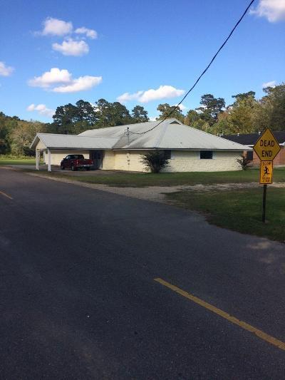
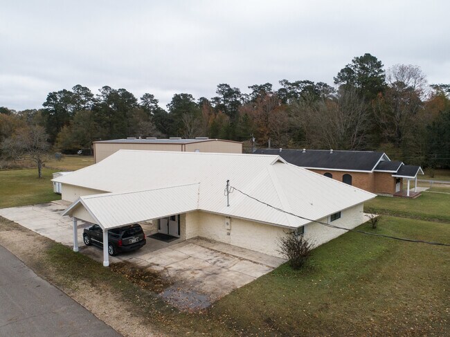
Property Record
Highway 442 W, , LA

Property Detail
Highway 442 W
Hammond, LA
3.33A LOT 3 OF ACT OF PART OF E34 OF SE14 OF SW14 OF SEC 27 T5SR7E TICKFAW B248 P495 B272 P543
02610701
TANGIPAHOA
Commercialacreage
Louisiana
AE The base floodplain where base flood elevations are provided. AE Zones are now used on new format FIRMs instead of A1-A30 Zones.
3
2025
3.33 AC
2025
Louisiana South Area
953900
Other Market Areas
NEARBY LISTINGS FOR SALE OR LEASE
-
-
View all listings for sale on LoopNet.com
DEMOGRAPHICS near Highway 442 W
1 mile
3 mile
5 mile
2025 Total Population
1,073
7,617
29,619
2030 Population
1,083
7,780
30,542
Pop Growth 2025-2030
+ 0.93%
+ 2.14%
+ 3.12%
Average Age
40
39
36
2025 Total Households
421
3,064
11,335
HH Growth 2025-2030
+ 1.19%
+ 2.25%
+ 3.33%
Median Household Inc
$44,285
$47,857
$51,522
Avg Household Size
2.50
2.50
2.40
2025 Avg HH Vehicles
2.00
2.00
2.00
Median Home Value
$167,226
$167,641
$196,188
Median Year Built
1983
1988
1988
Nearby Places
Map Layers
Map Styles
 Street
 Aerial
Layers
 Traffic
 Biking
Places
Listings with unknown addresses are not visible on the map
- Restaurants
- Banks
- Shops
- Fitness
- Groceries
PUBLIC TRANSPORTATION
COMMUTER RAIL
Drive
Walk
Distance
11 min
6.5 mi
Freight Ports
Port of Greater Baton Rouge
Drive
Walk
Distance
Port of Greater Baton Rouge
66 min
53.5 mi
SALE & LEASE HISTORY
LISTING DATE
SALE/LEASE

Nov 18, 2020
For Sale
Nearby Properties
Address
Land Use
TOTAL SIZE
Lot Size
Zoning
Address
Land Use
TOTAL SIZE
Lot Size
Zoning
6,252 SF
2.89 AC
Address
Land Use
TOTAL SIZE
Lot Size
Zoning
5,700 SF
2.50 AC
Address
Land Use
TOTAL SIZE
Lot Size
Zoning
50,020 SF
67.83 AC
Address
Land Use
TOTAL SIZE
Lot Size
Zoning
68,080 SF
20.06 AC
Address
Land Use
TOTAL SIZE
Lot Size
Zoning
11,904 SF
1.51 AC
Address
Land Use
TOTAL SIZE
Lot Size
Zoning
6,629 SF
10 AC
Address
Land Use
TOTAL SIZE
Lot Size
Zoning
12,726 SF
1.54 AC
Address
Land Use
TOTAL SIZE
Lot Size
Zoning
11,450 SF
9 AC
Address
Land Use
TOTAL SIZE
Lot Size
Zoning
15,000 SF
Address
Land Use
TOTAL SIZE
Lot Size
Zoning
34,000 SF
7.20 AC
Address
Land Use
TOTAL SIZE
Lot Size
Zoning
4,712 SF
2.04 AC
Address
Land Use
TOTAL SIZE
Lot Size
Zoning
20,250 SF
3.73 AC
Address
Land Use
TOTAL SIZE
Lot Size
Zoning
9,196 SF
0.78 AC
Address
Land Use
TOTAL SIZE
Lot Size
Zoning
8,172 SF
1.36 AC
Address
Land Use
TOTAL SIZE
Lot Size
Zoning
8,000 SF
1 AC
Address
Land Use
TOTAL SIZE
Lot Size
Zoning
1,476 SF
2 AC
Address
Land Use
TOTAL SIZE
Lot Size
Zoning
4,020 SF
2.72 AC
Address
Land Use
TOTAL SIZE
Lot Size
Zoning
6,596 SF
5.88 AC
Address
Land Use
TOTAL SIZE
Lot Size
Zoning
6,499 SF
4.21 AC
Address
Land Use
TOTAL SIZE
Lot Size
Zoning
16,000 SF
7.59 AC
Address
Land Use
TOTAL SIZE
Lot Size
Zoning
17,157 SF
2.48 AC
Address
Land Use
TOTAL SIZE
Lot Size
Zoning
6,324 SF
1.18 AC
Address
Land Use
TOTAL SIZE
Lot Size
Zoning
10,197 SF
1.12 AC
Address
Land Use
TOTAL SIZE
Lot Size
Zoning
1,840 SF
14.08 AC
Address
Land Use
TOTAL SIZE
Lot Size
Zoning
3,780 SF
6.50 AC
Address
Land Use
TOTAL SIZE
Lot Size
Zoning
9,000 SF
2.60 AC
Address
Land Use
TOTAL SIZE
Lot Size
Zoning
8,460 SF
1.50 AC
Address
Land Use
TOTAL SIZE
Lot Size
Zoning
3,500 SF
7.65 AC
Address
Land Use
TOTAL SIZE
Lot Size
Zoning
6,384 SF
0.95 AC
Address
Land Use
TOTAL SIZE
Lot Size
Zoning
6,000 SF
1.83 AC
The World's #1 Commercial Real Estate Marketplace
Connect with us
© 2026 CoStar Group
The information above has been obtained from sources believed reliable. While we do not doubt its accuracy we have not verified it and make no guarantee, warranty or representation about it. It is your responsibility to independently confirm its accuracy and completeness. Any projections, opinions, assumptions, or estimates used are for example only and do not represent the current or future performance of the property. The value of this transaction to you depends on tax and other factors which should be evaluated by your tax, financial, and legal advisors. You and your advisors should conduct a careful, independent investigation of the property to determine to your satisfaction the suitability of the property for your needs.