Property Record
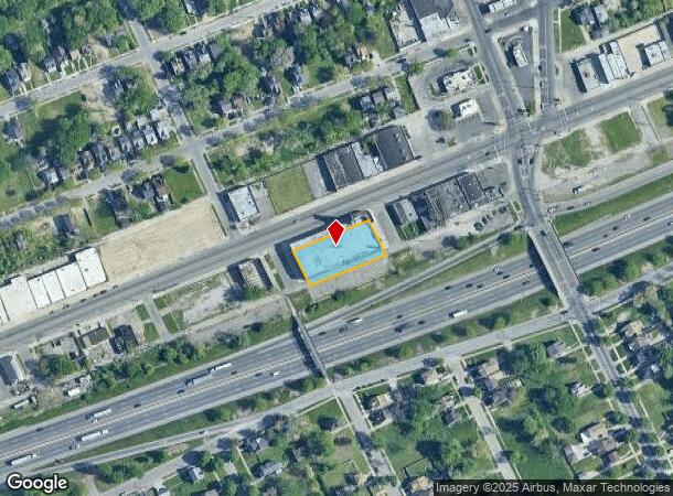
14238 Harper Ave, Detroit, MI 48213
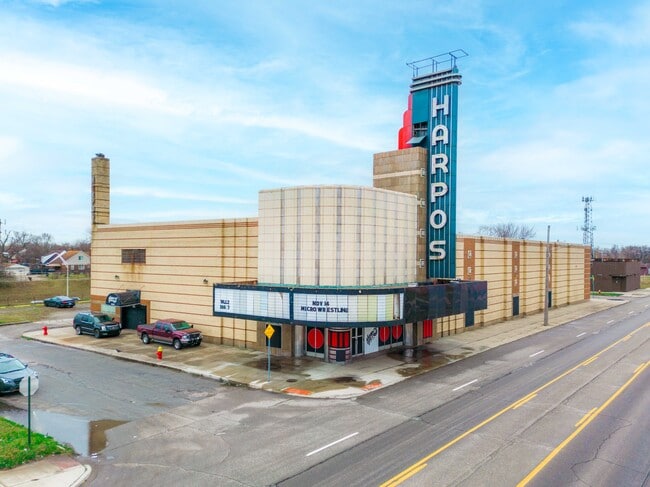

This Property Is For Sale
NEARBY LISTINGS FOR SALE OR LEASE
-
-
View all Detroit listings for sale on LoopNet.com
Property Detail
14238 Harper Ave
21-003983
Werners Park
Theater
S HARPER 141 THRU 132 WERNERS PARK SUB L43 P1 PLATS, W C R 21/621 214.25 X 100
X
Wayne
26163C0140F
Michigan
2024
0.49 AC
2025
Detroit E of Woodward
504200
Detroit
20,972 SF
Detroit-Warren-Dearborn, MI
DEMOGRAPHICS near 14238 Harper Ave
1 Mile
3 Mile
5 Mile
2024 Total Population
19,288
151,212
320,596
2029 Population
19,819
152,648
318,710
Pop Growth 2024-2029
+ 2.75%
+ 0.95%
(0.59%)
Average Age
37
38
38
2024 Total Households
6,983
56,332
121,694
HH Growth 2024-2029
+ 2.79%
+ 0.90%
(0.59%)
Median Household Inc
$31,035
$40,672
$44,250
Avg Household Size
2.60
2.60
2.50
2024 Avg HH Vehicles
1.00
1.00
1.00
Median Home Value
$69,648
$86,291
$107,121
Median Year Built
1950
1949
1950
Nearby Places
- Restaurants
- Banks
- Shops
- Fitness
- Groceries
PUBLIC TRANSPORTATION
COMMUTER RAIL
DRIVE
WALK
Distance
11 min
6.7 mi
AIRPORT
Windsor International
DRIVE
WALK
Distance
Windsor International
36 min
18.1 mi
Detroit Metro Wayne County
DRIVE
WALK
Distance
Detroit Metro Wayne County
40 min
27.6 mi
Nearby Properties
Address
Land Use
TOTAL SIZE
Lot Size
Zoning
Address
Land Use
TOTAL SIZE
Lot Size
Zoning
2,958,207 SF
277.38 AC
M4
Address
Land Use
TOTAL SIZE
Lot Size
Zoning
2,005,073 SF
108.66 AC
M4
Address
Land Use
TOTAL SIZE
Lot Size
Zoning
929,400 SF
52.48 AC
M4
Address
Land Use
TOTAL SIZE
Lot Size
Zoning
482,649 SF
M4
Address
Land Use
TOTAL SIZE
Lot Size
Zoning
575,081 SF
8.53 AC
R6
Address
Land Use
TOTAL SIZE
Lot Size
Zoning
182,866 SF
5.08 AC
PD
Address
Land Use
TOTAL SIZE
Lot Size
Zoning
144,578 SF
7.10 AC
PD
Address
Land Use
TOTAL SIZE
Lot Size
Zoning
57.16 AC
M4
Address
Land Use
TOTAL SIZE
Lot Size
Zoning
93,296 SF
1.05 AC
C-2
Address
Land Use
TOTAL SIZE
Lot Size
Zoning
358,327 SF
M4
Address
Land Use
TOTAL SIZE
Lot Size
Zoning
302,305 SF
M4
Address
Land Use
TOTAL SIZE
Lot Size
Zoning
89,897 SF
2.23 AC
Address
Land Use
TOTAL SIZE
Lot Size
Zoning
129,260 SF
3 AC
B4
Address
Land Use
TOTAL SIZE
Lot Size
Zoning
72,940 SF
83.37 AC
M4
Address
Land Use
TOTAL SIZE
Lot Size
Zoning
93,850 SF
6.56 AC
Address
Land Use
TOTAL SIZE
Lot Size
Zoning
88,695 SF
6.53 AC
PD
Address
Land Use
TOTAL SIZE
Lot Size
Zoning
115,839 SF
8.54 AC
M4
Address
Land Use
TOTAL SIZE
Lot Size
Zoning
36,417 SF
0.68 AC
B4
Address
Land Use
TOTAL SIZE
Lot Size
Zoning
20,625 SF
0.48 AC
C-2
Address
Land Use
TOTAL SIZE
Lot Size
Zoning
49,807 SF
0.84 AC
PD
Address
Land Use
TOTAL SIZE
Lot Size
Zoning
47,227 SF
6.29 AC
PD
Address
Land Use
TOTAL SIZE
Lot Size
Zoning
36,086 SF
2.05 AC
B2
Address
Land Use
TOTAL SIZE
Lot Size
Zoning
55,321 SF
4.01 AC
PD
Address
Land Use
TOTAL SIZE
Lot Size
Zoning
176,106 SF
11.95 AC
M4
Address
Land Use
TOTAL SIZE
Lot Size
Zoning
101,814 SF
3.74 AC
R-2
Address
Land Use
TOTAL SIZE
Lot Size
Zoning
60,484 SF
4.85 AC
PD
Address
Land Use
TOTAL SIZE
Lot Size
Zoning
16.16 AC
PD
Address
Land Use
TOTAL SIZE
Lot Size
Zoning
167,364 SF
8.40 AC
M2
Address
Land Use
TOTAL SIZE
Lot Size
Zoning
65,490 SF
17.71 AC
M2
Address
Land Use
TOTAL SIZE
Lot Size
Zoning
14,820 SF
0.41 AC
C-1
The World's #1 Commercial Real Estate Marketplace
Connect with us
© 2025 CoStar Group
The information above has been obtained from sources believed reliable. While we do not doubt its accuracy we have not verified it and make no guarantee, warranty or representation about it. It is your responsibility to independently confirm its accuracy and completeness. Any projections, opinions, assumptions, or estimates used are for example only and do not represent the current or future performance of the property. The value of this transaction to you depends on tax and other factors which should be evaluated by your tax, financial, and legal advisors. You and your advisors should conduct a careful, independent investigation of the property to determine to your satisfaction the suitability of the property for your needs.