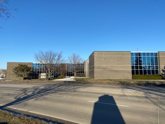
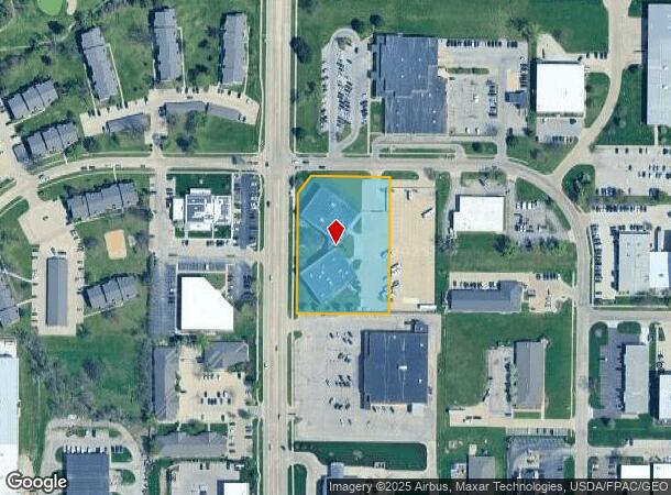
Property Record
1425 60Th St Ne, Cedar Rapids, IA 52402

NEARBY LISTINGS FOR SALE OR LEASE
Property Detail
1425 60Th St Ne
Other Market Areas
Industrial Park 1St
Cedar Rapids, IA
COUNCIL STREET INDUSTRIAL PARK 1ST (LESS ST) STR/LB 3
11343-52004-00000
Linn
Shipyard
Iowa
2024
1
2025
2.02 AC
000213
Iowa City/Waterloo
24,372 SF
DEMOGRAPHICS near 1425 60Th St Ne
1 Mile
3 Mile
5 Mile
2024 Total Population
8,089
62,394
134,306
2029 Population
8,082
62,111
133,729
Pop Growth 2024-2029
(0.09%)
(0.45%)
(0.43%)
Average Age
38
40
40
2024 Total Households
3,815
26,837
56,070
HH Growth 2024-2029
(0.13%)
(0.49%)
(0.44%)
Median Household Inc
$57,999
$68,463
$68,218
Avg Household Size
2.10
2.30
2.30
2024 Avg HH Vehicles
1.00
2.00
2.00
Median Home Value
$168,062
$187,846
$189,629
Median Year Built
1984
1977
1975
Nearby Places
Map Layers
Map Styles
 Street
 Aerial
- Restaurants
- Banks
- Shops
- Fitness
- Groceries
PUBLIC TRANSPORTATION
AIRPORT
The Eastern Iowa
DRIVE
WALK
Distance
The Eastern Iowa
24 min
14.9 mi
Freight Ports
Port Milwaukee
DRIVE
WALK
Distance
Port Milwaukee
290 min
244.4 mi
SALE & LEASE HISTORY
LISTING DATE
SALE/LEASE

Mar 15, 2021
For Lease
Mar 15, 2021
For Sale
Nearby Properties
Address
Land Use
TOTAL SIZE
Lot Size
Zoning
Address
Land Use
TOTAL SIZE
Lot Size
Zoning
185,414 SF
40.86 AC
Address
Land Use
TOTAL SIZE
Lot Size
Zoning
530,727 SF
28.94 AC
Address
Land Use
TOTAL SIZE
Lot Size
Zoning
160,822 SF
23.06 AC
Address
Land Use
TOTAL SIZE
Lot Size
Zoning
276,234 SF
44.53 AC
Address
Land Use
TOTAL SIZE
Lot Size
Zoning
70,022 SF
8.27 AC
Address
Land Use
TOTAL SIZE
Lot Size
Zoning
103,528 SF
18.54 AC
Address
Land Use
TOTAL SIZE
Lot Size
Zoning
140,672 SF
15.99 AC
Address
Land Use
TOTAL SIZE
Lot Size
Zoning
189,595 SF
19.12 AC
Address
Land Use
TOTAL SIZE
Lot Size
Zoning
1,156,491 SF
137 AC
Address
Land Use
TOTAL SIZE
Lot Size
Zoning
74,015 SF
6.59 AC
Address
Land Use
TOTAL SIZE
Lot Size
Zoning
22,809 SF
21.48 AC
Address
Land Use
TOTAL SIZE
Lot Size
Zoning
393,375 SF
100.66 AC
Address
Land Use
TOTAL SIZE
Lot Size
Zoning
406,933 SF
61.58 AC
Address
Land Use
TOTAL SIZE
Lot Size
Zoning
34,710 SF
3.30 AC
Address
Land Use
TOTAL SIZE
Lot Size
Zoning
69,683 SF
24.78 AC
Address
Land Use
TOTAL SIZE
Lot Size
Zoning
61,291 SF
35.88 AC
Address
Land Use
TOTAL SIZE
Lot Size
Zoning
155,200 SF
32.40 AC
Address
Land Use
TOTAL SIZE
Lot Size
Zoning
149,826 SF
45 AC
Address
Land Use
TOTAL SIZE
Lot Size
Zoning
44,972 SF
7.03 AC
Address
Land Use
TOTAL SIZE
Lot Size
Zoning
72,227 SF
18.86 AC
Address
Land Use
TOTAL SIZE
Lot Size
Zoning
90,345 SF
40 AC
Address
Land Use
TOTAL SIZE
Lot Size
Zoning
28,506 SF
5.30 AC
Address
Land Use
TOTAL SIZE
Lot Size
Zoning
67,108 SF
4.81 AC
Address
Land Use
TOTAL SIZE
Lot Size
Zoning
225,076 SF
17.04 AC
Address
Land Use
TOTAL SIZE
Lot Size
Zoning
70,158 SF
3.76 AC
Address
Land Use
TOTAL SIZE
Lot Size
Zoning
173,941 SF
15.45 AC
Address
Land Use
TOTAL SIZE
Lot Size
Zoning
63,234 SF
2.20 AC
Address
Land Use
TOTAL SIZE
Lot Size
Zoning
44,544 SF
7.11 AC
Address
Land Use
TOTAL SIZE
Lot Size
Zoning
60,616 SF
8.40 AC
Address
Land Use
TOTAL SIZE
Lot Size
Zoning
61,505 SF
28.08 AC
The World's #1 Commercial Real Estate Marketplace
Connect with us
© 2025 CoStar Group
The information above has been obtained from sources believed reliable. While we do not doubt its accuracy we have not verified it and make no guarantee, warranty or representation about it. It is your responsibility to independently confirm its accuracy and completeness. Any projections, opinions, assumptions, or estimates used are for example only and do not represent the current or future performance of the property. The value of this transaction to you depends on tax and other factors which should be evaluated by your tax, financial, and legal advisors. You and your advisors should conduct a careful, independent investigation of the property to determine to your satisfaction the suitability of the property for your needs.