Property Record
1425 Bertha Howe Ave, Mesquite, NV 89034
NEARBY LISTINGS FOR SALE OR LEASE
-
-
-
Interstate 15 Southbound Exit Corner & Falcon Ridge
Mesquite, NV 89027
$3,450,000
10.69 AC Lots
Land
-
-
-
-
-
View all Mesquite listings for sale on LoopNet.com
Property Detail
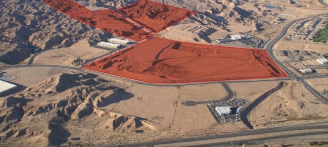
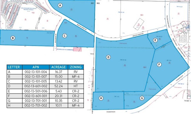
1425 Bertha Howe Ave
Las Vegas-Henderson-North Las Vegas, NV
Parcel Map File 115 Page 37
002-13-101-004
PARCEL MAP FILE 115 PAGE 37 LOT 1
Vacantlandnec
Clark
X
Nevada
04015C0400G
1
2025
16.37 AC
2025
Outlying NE Clark County
005904
Las Vegas
DEMOGRAPHICS near 1425 Bertha Howe Ave
1 Mile
3 Mile
5 Mile
2024 Total Population
1,606
21,084
26,947
2029 Population
1,788
23,330
29,788
Pop Growth 2024-2029
+ 11.33%
+ 10.65%
+ 10.54%
Average Age
63
54
54
2024 Total Households
829
9,518
12,338
HH Growth 2024-2029
+ 11.22%
+ 10.91%
+ 10.74%
Median Household Inc
$67,299
$68,237
$65,786
Avg Household Size
1.90
2.20
2.10
2024 Avg HH Vehicles
2.00
2.00
2.00
Median Home Value
$372,058
$374,395
$369,504
Median Year Built
2007
2005
2004
Nearby Places
Map Layers
Map Styles
 Street
 Aerial
- Restaurants
- Banks
- Shops
- Fitness
- Groceries
SALE & LEASE HISTORY
LISTING DATE
SALE/LEASE

Sep 24, 2016
For Sale
Nearby Properties
Address
Land Use
TOTAL SIZE
Lot Size
Zoning
Address
Land Use
TOTAL SIZE
Lot Size
Zoning
148,373 SF
19.35 AC
HT
Address
Land Use
TOTAL SIZE
Lot Size
Zoning
568,590 SF
63.57 AC
Address
Land Use
TOTAL SIZE
Lot Size
Zoning
568,553 SF
56.06 AC
IR1
Address
Land Use
TOTAL SIZE
Lot Size
Zoning
83,429 SF
23.92 AC
CRH
Address
Land Use
TOTAL SIZE
Lot Size
Zoning
496,775 SF
5.02 AC
HT
Address
Land Use
TOTAL SIZE
Lot Size
Zoning
37.78 AC
PROS
Address
Land Use
TOTAL SIZE
Lot Size
Zoning
12.49 AC
PF
Address
Land Use
TOTAL SIZE
Lot Size
Zoning
154,961 SF
17.17 AC
PUD
Address
Land Use
TOTAL SIZE
Lot Size
Zoning
10.07 AC
PF
Address
Land Use
TOTAL SIZE
Lot Size
Zoning
107,554 SF
10.04 AC
Address
Land Use
TOTAL SIZE
Lot Size
Zoning
10.09 AC
PF
Address
Land Use
TOTAL SIZE
Lot Size
Zoning
81,518 SF
1.87 AC
PUD
Address
Land Use
TOTAL SIZE
Lot Size
Zoning
3,450 SF
4.93 AC
PB
Address
Land Use
TOTAL SIZE
Lot Size
Zoning
6,831 SF
6.01 AC
CR2
Address
Land Use
TOTAL SIZE
Lot Size
Zoning
111,642 SF
8.35 AC
IR1
Address
Land Use
TOTAL SIZE
Lot Size
Zoning
47,328 SF
4.65 AC
CR2
Address
Land Use
TOTAL SIZE
Lot Size
Zoning
66,537 SF
6.27 AC
PUD
Address
Land Use
TOTAL SIZE
Lot Size
Zoning
1,056 SF
5.96 AC
MF4
Address
Land Use
TOTAL SIZE
Lot Size
Zoning
13,286 SF
1.63 AC
Address
Land Use
TOTAL SIZE
Lot Size
Zoning
11,249 SF
220.36 AC
PUD
Address
Land Use
TOTAL SIZE
Lot Size
Zoning
36,233 SF
3.31 AC
PUD
Address
Land Use
TOTAL SIZE
Lot Size
Zoning
20,299 SF
0.99 AC
CR2
Address
Land Use
TOTAL SIZE
Lot Size
Zoning
37,245 SF
8.50 AC
IR1
Address
Land Use
TOTAL SIZE
Lot Size
Zoning
34,032 SF
3.15 AC
PUD
Address
Land Use
TOTAL SIZE
Lot Size
Zoning
50,402 SF
6.14 AC
IR1
Address
Land Use
TOTAL SIZE
Lot Size
Zoning
34,737 SF
2.54 AC
The World's #1 Commercial Real Estate Marketplace
Connect with us
© 2026 CoStar Group
The information above has been obtained from sources believed reliable. While we do not doubt its accuracy we have not verified it and make no guarantee, warranty or representation about it. It is your responsibility to independently confirm its accuracy and completeness. Any projections, opinions, assumptions, or estimates used are for example only and do not represent the current or future performance of the property. The value of this transaction to you depends on tax and other factors which should be evaluated by your tax, financial, and legal advisors. You and your advisors should conduct a careful, independent investigation of the property to determine to your satisfaction the suitability of the property for your needs.