Property Record
1425 E College Way, Olathe, KS 66062

NEARBY LISTINGS FOR SALE OR LEASE
-
-
View all Olathe listings for sale on LoopNet.com
Property Detail
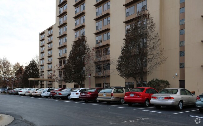
1425 E College Way
Kansas City, MO-KS
Havencroft
DP30000030-0026A
HAVENCROFT LT 25 & PT LT 26 BLK 30 ENTIRE TR DESC AS BG NECR LT 25 NW 190.79 SW 263.52SE 209.58 & 45 NE 420 TO BGPARKING OLC 637A 30 25 BOTA 92 545 TX
Hospitalprivate
Johnson
X
Kansas
20091C0094G
25-26
2024
3.50 AC
2024
Havencroft
053502
Kansas City
13,447 SF
DEMOGRAPHICS near 1425 E College Way
1 Mile
3 Mile
5 Mile
2024 Total Population
12,755
100,731
175,856
2029 Population
13,156
104,434
183,341
Pop Growth 2024-2029
+ 3.14%
+ 3.68%
+ 4.26%
Average Age
36
37
38
2024 Total Households
4,622
36,112
63,472
HH Growth 2024-2029
+ 3.22%
+ 3.84%
+ 4.34%
Median Household Inc
$62,198
$89,176
$102,457
Avg Household Size
2.50
2.70
2.70
2024 Avg HH Vehicles
2.00
2.00
2.00
Median Home Value
$232,017
$267,489
$325,512
Median Year Built
1974
1988
1994
Nearby Places
Map Layers
Map Styles
 Street
 Aerial
- Restaurants
- Banks
- Shops
- Fitness
- Groceries
PUBLIC TRANSPORTATION
AIRPORT
Kansas City International
DRIVE
WALK
Distance
Kansas City International
48 min
38.1 mi
Freight Ports
Tulsa Port Of Catoosa
DRIVE
WALK
Distance
Tulsa Port Of Catoosa
255 min
224.4 mi
Nearby Properties
Address
Land Use
TOTAL SIZE
Lot Size
Zoning
Address
Land Use
TOTAL SIZE
Lot Size
Zoning
401,604 SF
28.35 AC
CP-O
Address
Land Use
TOTAL SIZE
Lot Size
Zoning
307,761 SF
6.59 AC
C-2
Address
Land Use
TOTAL SIZE
Lot Size
Zoning
482,713 SF
77.78 AC
AG
Address
Land Use
TOTAL SIZE
Lot Size
Zoning
162,499 SF
38.74 AC
R-1
Address
Land Use
TOTAL SIZE
Lot Size
Zoning
512,643 SF
75.55 AC
AG
Address
Land Use
TOTAL SIZE
Lot Size
Zoning
456,742 SF
27.31 AC
R-1
Address
Land Use
TOTAL SIZE
Lot Size
Zoning
97,340 SF
1.82 AC
C-2
Address
Land Use
TOTAL SIZE
Lot Size
Zoning
211,054 SF
77.48 AC
R-1
Address
Land Use
TOTAL SIZE
Lot Size
Zoning
88,459 SF
15.13 AC
R-1
Address
Land Use
TOTAL SIZE
Lot Size
Zoning
130,576 SF
15.20 AC
RP-4
Address
Land Use
TOTAL SIZE
Lot Size
Zoning
323,377 SF
15.55 AC
R-1
Address
Land Use
TOTAL SIZE
Lot Size
Zoning
211,785 SF
35.56 AC
RP-3
Address
Land Use
TOTAL SIZE
Lot Size
Zoning
19,460 SF
9.12 AC
R-1
Address
Land Use
TOTAL SIZE
Lot Size
Zoning
66,664 SF
2.94 AC
C-2
Address
Land Use
TOTAL SIZE
Lot Size
Zoning
202,726 SF
9.37 AC
R-1
Address
Land Use
TOTAL SIZE
Lot Size
Zoning
40,647 SF
7.40 AC
R-4
Address
Land Use
TOTAL SIZE
Lot Size
Zoning
177,274 SF
2.69 AC
C-2
Address
Land Use
TOTAL SIZE
Lot Size
Zoning
251,981 SF
10.79 AC
R-5
Address
Land Use
TOTAL SIZE
Lot Size
Zoning
129,325 SF
4.50 AC
R-1
Address
Land Use
TOTAL SIZE
Lot Size
Zoning
137,955 SF
23.80 AC
R-1
Address
Land Use
TOTAL SIZE
Lot Size
Zoning
107,857 SF
10.94 AC
C-2
Address
Land Use
TOTAL SIZE
Lot Size
Zoning
137,122 SF
7.68 AC
C-1
Address
Land Use
TOTAL SIZE
Lot Size
Zoning
146,832 SF
30 AC
R-1
Address
Land Use
TOTAL SIZE
Lot Size
Zoning
53,359 SF
41.55 AC
R-1
Address
Land Use
TOTAL SIZE
Lot Size
Zoning
150,122 SF
17.48 AC
R-1
Address
Land Use
TOTAL SIZE
Lot Size
Zoning
934,106 SF
34.09 AC
BP
Address
Land Use
TOTAL SIZE
Lot Size
Zoning
157,344 SF
12.69 AC
R-1
Address
Land Use
TOTAL SIZE
Lot Size
Zoning
44,486 SF
2.70 AC
C-2
Address
Land Use
TOTAL SIZE
Lot Size
Zoning
61,479 SF
8.14 AC
C-2
Address
Land Use
TOTAL SIZE
Lot Size
Zoning
130,605 SF
18.01 AC
R-1
The World's #1 Commercial Real Estate Marketplace
Connect with us
© 2025 CoStar Group
The information above has been obtained from sources believed reliable. While we do not doubt its accuracy we have not verified it and make no guarantee, warranty or representation about it. It is your responsibility to independently confirm its accuracy and completeness. Any projections, opinions, assumptions, or estimates used are for example only and do not represent the current or future performance of the property. The value of this transaction to you depends on tax and other factors which should be evaluated by your tax, financial, and legal advisors. You and your advisors should conduct a careful, independent investigation of the property to determine to your satisfaction the suitability of the property for your needs.