Property Record
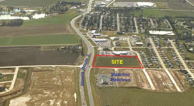
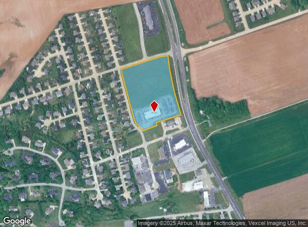
1425 N Illinois Route 3, Waterloo, IL 62298
NEARBY LISTINGS FOR SALE OR LEASE
Property Detail
1425 N Illinois Route 3
St. Louis, MO-IL
Dannehold Farm Estates
07-12-365-005-000
LOT 5 DANNEHOLD FARM ESTATES PHASE 2 PLAT 1
Commercialnec
Monroe
X
Illinois
17133C0160F
5
2024
9.92 AC
2024
Monroe County
600402
St. Louis
DEMOGRAPHICS near 1425 N Illinois Route 3
1 Mile
3 Mile
5 Mile
2024 Total Population
1,211
10,285
16,818
2029 Population
1,212
10,334
16,857
Pop Growth 2024-2029
+ 0.08%
+ 0.48%
+ 0.23%
Average Age
43
42
42
2024 Total Households
450
4,153
6,656
HH Growth 2024-2029
0.00%
+ 0.53%
+ 0.26%
Median Household Inc
$89,062
$83,633
$90,491
Avg Household Size
2.60
2.40
2.50
2024 Avg HH Vehicles
2.00
2.00
2.00
Median Home Value
$288,425
$239,505
$254,402
Median Year Built
1994
1990
1990
Nearby Places
Map Layers
Map Styles
 Street
 Aerial
- Restaurants
- Banks
- Shops
- Fitness
- Groceries
PUBLIC TRANSPORTATION
AIRPORT
Scott AFB/Midamerica St Louis
DRIVE
WALK
Distance
Scott AFB/Midamerica St Louis
51 min
28.5 mi
St Louis Lambert International
DRIVE
WALK
Distance
St Louis Lambert International
52 min
35.3 mi
Freight Ports
Tulsa Port of Inola
DRIVE
WALK
Distance
Tulsa Port of Inola
434 min
391.1 mi
SALE & LEASE HISTORY
LISTING DATE
SALE/LEASE

Sep 25, 2016
For Lease
Apr 24, 2018
For Sale
Nearby Properties
Address
Land Use
TOTAL SIZE
Lot Size
Zoning
Address
Land Use
TOTAL SIZE
Lot Size
Zoning
25.16 AC
WI1
Address
Land Use
TOTAL SIZE
Lot Size
Zoning
0.55 AC
WB3
Address
Land Use
TOTAL SIZE
Lot Size
Zoning
4 AC
WR5
Address
Land Use
TOTAL SIZE
Lot Size
Zoning
3.50 AC
WB3
Address
Land Use
TOTAL SIZE
Lot Size
Zoning
2.32 AC
WB2
Address
Land Use
TOTAL SIZE
Lot Size
Zoning
7.62 AC
MA2
Address
Land Use
TOTAL SIZE
Lot Size
Zoning
2.24 AC
WB2
Address
Land Use
TOTAL SIZE
Lot Size
Zoning
1.55 AC
MB2
Address
Land Use
TOTAL SIZE
Lot Size
Zoning
2.12 AC
WB2
Address
Land Use
TOTAL SIZE
Lot Size
Zoning
1.67 AC
WB2
Address
Land Use
TOTAL SIZE
Lot Size
Zoning
1.98 AC
WB2
Address
Land Use
TOTAL SIZE
Lot Size
Zoning
1.56 AC
WB3
Address
Land Use
TOTAL SIZE
Lot Size
Zoning
3.10 AC
WR5
Address
Land Use
TOTAL SIZE
Lot Size
Zoning
1.08 AC
WR5
Address
Land Use
TOTAL SIZE
Lot Size
Zoning
2.91 AC
MB2
Address
Land Use
TOTAL SIZE
Lot Size
Zoning
1.30 AC
WB3
Address
Land Use
TOTAL SIZE
Lot Size
Zoning
0.80 AC
WB3
Address
Land Use
TOTAL SIZE
Lot Size
Zoning
1.14 AC
WB3
Address
Land Use
TOTAL SIZE
Lot Size
Zoning
2.29 AC
WR5
Address
Land Use
TOTAL SIZE
Lot Size
Zoning
4.33 AC
MB2
Address
Land Use
TOTAL SIZE
Lot Size
Zoning
1.09 AC
WB3
Address
Land Use
TOTAL SIZE
Lot Size
Zoning
1.73 AC
WI1
Address
Land Use
TOTAL SIZE
Lot Size
Zoning
0.59 AC
Address
Land Use
TOTAL SIZE
Lot Size
Zoning
1.31 AC
WB3
Address
Land Use
TOTAL SIZE
Lot Size
Zoning
7,172 SF
24 AC
MA2
Address
Land Use
TOTAL SIZE
Lot Size
Zoning
1.94 AC
MB2
Address
Land Use
TOTAL SIZE
Lot Size
Zoning
2,778 SF
1.06 AC
WB2
Address
Land Use
TOTAL SIZE
Lot Size
Zoning
1.72 AC
WB3
Address
Land Use
TOTAL SIZE
Lot Size
Zoning
1.23 AC
WB3
The World's #1 Commercial Real Estate Marketplace
Connect with us
© 2026 CoStar Group
The information above has been obtained from sources believed reliable. While we do not doubt its accuracy we have not verified it and make no guarantee, warranty or representation about it. It is your responsibility to independently confirm its accuracy and completeness. Any projections, opinions, assumptions, or estimates used are for example only and do not represent the current or future performance of the property. The value of this transaction to you depends on tax and other factors which should be evaluated by your tax, financial, and legal advisors. You and your advisors should conduct a careful, independent investigation of the property to determine to your satisfaction the suitability of the property for your needs.