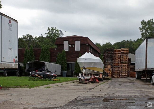
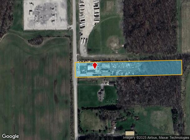
Property Record
14250 Romine Rd, Carleton, MI 48117

NEARBY LISTINGS FOR SALE OR LEASE
-
-
View all Carleton listings for sale on LoopNet.com
Property Detail
14250 Romine Rd
01-003-028-10
SEC 3 T5S R9E 3 A COM AT A PT ON E LI OF ROMINE RD DIST S 0 DEG 57' 20" W 892.57 FT ALG W LI OF SEC 3 & S 89 DEG 52' 40" E 33
Lightindustrial
Monroe
X
Michigan
26115C0103E
3 AC
2024
Monroe County
2025
Detroit
830300
Monroe, MI
8,100 SF
DEMOGRAPHICS near 14250 Romine Rd
1 Mile
3 Mile
5 Mile
2024 Total Population
254
10,770
32,783
2029 Population
260
10,732
32,149
Pop Growth 2024-2029
+ 2.36%
(0.35%)
(1.93%)
Average Age
48
41
42
2024 Total Households
105
4,134
12,711
HH Growth 2024-2029
+ 1.90%
+ 0.05%
(1.82%)
Median Household Inc
$72,115
$72,824
$76,366
Avg Household Size
2.40
2.60
2.50
2024 Avg HH Vehicles
2.00
2.00
2.00
Median Home Value
$226,923
$240,039
$254,731
Median Year Built
1983
1991
1987
Nearby Places
Map Layers
Map Styles
 Street
 Aerial
- Restaurants
- Banks
- Shops
- Fitness
- Groceries
PUBLIC TRANSPORTATION
AIRPORT
Detroit Metro Wayne County
DRIVE
WALK
Distance
Detroit Metro Wayne County
17 min
11.2 mi
Windsor International
DRIVE
WALK
Distance
Windsor International
59 min
35.5 mi
Freight Ports
Port of Toledo
DRIVE
WALK
Distance
Port of Toledo
51 min
37.9 mi
Nearby Properties
Address
Land Use
TOTAL SIZE
Lot Size
Zoning
Address
Land Use
TOTAL SIZE
Lot Size
Zoning
249,112 SF
Address
Land Use
TOTAL SIZE
Lot Size
Zoning
169,300 SF
229.95 AC
Address
Land Use
TOTAL SIZE
Lot Size
Zoning
3,520 SF
62.97 AC
MHP MOB
Address
Land Use
TOTAL SIZE
Lot Size
Zoning
796,126 SF
54 AC
Address
Land Use
TOTAL SIZE
Lot Size
Zoning
40,101 SF
12.60 AC
Address
Land Use
TOTAL SIZE
Lot Size
Zoning
44.13 AC
MHP MOB
Address
Land Use
TOTAL SIZE
Lot Size
Zoning
30,719 SF
9.93 AC
AG AGRI
Address
Land Use
TOTAL SIZE
Lot Size
Zoning
18,520 SF
326.27 AC
Address
Land Use
TOTAL SIZE
Lot Size
Zoning
3,954 SF
36.96 AC
MHP
Address
Land Use
TOTAL SIZE
Lot Size
Zoning
2,520 SF
27.80 AC
MHP
Address
Land Use
TOTAL SIZE
Lot Size
Zoning
91,075 SF
9.07 AC
Address
Land Use
TOTAL SIZE
Lot Size
Zoning
Address
Land Use
TOTAL SIZE
Lot Size
Zoning
2,304 SF
50.50 AC
Address
Land Use
TOTAL SIZE
Lot Size
Zoning
39,078 SF
2.08 AC
Address
Land Use
TOTAL SIZE
Lot Size
Zoning
37,661 SF
10.02 AC
Address
Land Use
TOTAL SIZE
Lot Size
Zoning
27,567 SF
11.46 AC
Address
Land Use
TOTAL SIZE
Lot Size
Zoning
72,151 SF
8.47 AC
Address
Land Use
TOTAL SIZE
Lot Size
Zoning
11.16 AC
MHP MOB
Address
Land Use
TOTAL SIZE
Lot Size
Zoning
81.31 AC
AG AGRI
Address
Land Use
TOTAL SIZE
Lot Size
Zoning
7,184 SF
29.93 AC
Address
Land Use
TOTAL SIZE
Lot Size
Zoning
48.31 AC
AG AGRI
Address
Land Use
TOTAL SIZE
Lot Size
Zoning
6,106 SF
2.15 AC
Address
Land Use
TOTAL SIZE
Lot Size
Zoning
6,000 SF
7.24 AC
Address
Land Use
TOTAL SIZE
Lot Size
Zoning
5,319 SF
135.74 AC
Address
Land Use
TOTAL SIZE
Lot Size
Zoning
21,832 SF
5.57 AC
Address
Land Use
TOTAL SIZE
Lot Size
Zoning
36.94 AC
Address
Land Use
TOTAL SIZE
Lot Size
Zoning
12,000 SF
3.44 AC
Address
Land Use
TOTAL SIZE
Lot Size
Zoning
600 SF
32.66 AC
SP SPEC
Address
Land Use
TOTAL SIZE
Lot Size
Zoning
3.38 AC
Address
Land Use
TOTAL SIZE
Lot Size
Zoning
5,600 SF
32.96 AC
The World's #1 Commercial Real Estate Marketplace
Connect with us
© 2025 CoStar Group
The information above has been obtained from sources believed reliable. While we do not doubt its accuracy we have not verified it and make no guarantee, warranty or representation about it. It is your responsibility to independently confirm its accuracy and completeness. Any projections, opinions, assumptions, or estimates used are for example only and do not represent the current or future performance of the property. The value of this transaction to you depends on tax and other factors which should be evaluated by your tax, financial, and legal advisors. You and your advisors should conduct a careful, independent investigation of the property to determine to your satisfaction the suitability of the property for your needs.