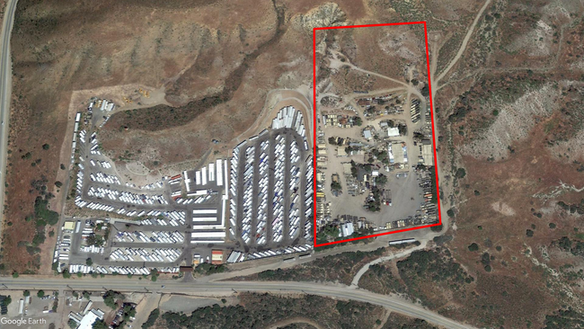
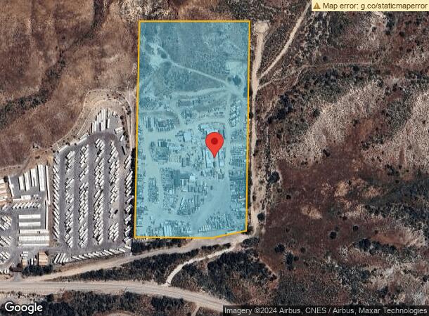
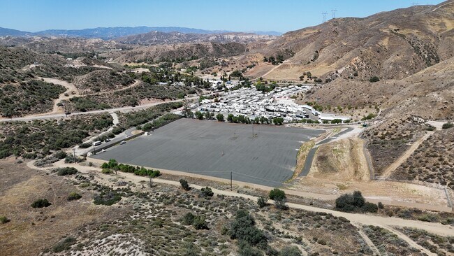
Property Record
14253 Davenport Rd, Santa Clarita, CA 91390

Current Lease Availabilities
NEARBY LISTINGS FOR SALE OR LEASE
Property Detail
14253 Davenport Rd
2813-020-002
11.06 MORE OR LESS ACS BEING EX OF ST W 495 FT OF N 990 FT OF SE 1/4 OF SE 1/4 OF SEC 30 T 5N R 14W
Shipyard
Los Angeles
X
California
06037C0835G
30
2024
11.55 AC
2025
Santa Clarita Valley
910814
Los Angeles
976 SF
Los Angeles-Long Beach-Glendale, CA
DEMOGRAPHICS near 14253 Davenport Rd
1 Mile
3 Mile
5 Mile
2024 Total Population
222
5,882
20,692
2029 Population
214
5,658
19,798
Pop Growth 2024-2029
(3.60%)
(3.81%)
(4.32%)
Average Age
43
42
40
2024 Total Households
74
1,893
6,512
HH Growth 2024-2029
(4.05%)
(4.12%)
(4.55%)
Median Household Inc
$96,428
$113,445
$115,312
Avg Household Size
2.90
3.10
3.10
2024 Avg HH Vehicles
3.00
3.00
3.00
Median Home Value
$750,000
$736,233
$730,571
Median Year Built
1978
1981
1984
Nearby Places
Map Layers
Map Styles
 Street
 Aerial
- Restaurants
- Banks
- Shops
- Fitness
- Groceries
PUBLIC TRANSPORTATION
COMMUTER RAIL
Via Princessa (Antelope Valley Line - Southern California Regional Rail Authority (Metrolink))
DRIVE
WALK
Distance
Via Princessa (Antelope Valley Line - Southern California Regional Rail Authority (Metrolink))
13 min
7.9 mi
Vista Canyon Metrolink Station (Metrolink Antelope Valley Line - Metrolink Trains)
DRIVE
WALK
Distance
Vista Canyon Metrolink Station (Metrolink Antelope Valley Line - Metrolink Trains)
16 min
8.7 mi
AIRPORT
Bob Hope
DRIVE
WALK
Distance
Bob Hope
37 min
27.6 mi
Freight Ports
Port of Long Beach
DRIVE
WALK
Distance
Port of Long Beach
80 min
64.1 mi
Nearby Properties
Address
Land Use
TOTAL SIZE
Lot Size
Zoning
Address
Land Use
TOTAL SIZE
Lot Size
Zoning
165.83 AC
LCR1
Address
Land Use
TOTAL SIZE
Lot Size
Zoning
112.98 AC
LCA1
Address
Land Use
TOTAL SIZE
Lot Size
Zoning
27.39 AC
LCM1-A11*
Address
Land Use
TOTAL SIZE
Lot Size
Zoning
Address
Land Use
TOTAL SIZE
Lot Size
Zoning
840 SF
31.53 AC
LCC3-A11*
Address
Land Use
TOTAL SIZE
Lot Size
Zoning
148.76 AC
LCC3-A11-R
Address
Land Use
TOTAL SIZE
Lot Size
Zoning
Address
Land Use
TOTAL SIZE
Lot Size
Zoning
3.89 AC
LCM1-A11*
Address
Land Use
TOTAL SIZE
Lot Size
Zoning
43,967 SF
40.97 AC
LCM11/2*
Address
Land Use
TOTAL SIZE
Lot Size
Zoning
17,325 SF
9.94 AC
LCM1-A11*
Address
Land Use
TOTAL SIZE
Lot Size
Zoning
7,444 SF
1.84 AC
LCM1*
Address
Land Use
TOTAL SIZE
Lot Size
Zoning
19.70 AC
LCA110000*
Address
Land Use
TOTAL SIZE
Lot Size
Zoning
4,638 SF
10.71 AC
LCM1
Address
Land Use
TOTAL SIZE
Lot Size
Zoning
6,345 SF
26.72 AC
LCC4-A1200
Address
Land Use
TOTAL SIZE
Lot Size
Zoning
2,960 SF
12.42 AC
LCC3-A1L*
Address
Land Use
TOTAL SIZE
Lot Size
Zoning
6,015 SF
14.87 AC
LCA11*
Address
Land Use
TOTAL SIZE
Lot Size
Zoning
4,000 SF
9.57 AC
LCM1-A21*
Address
Land Use
TOTAL SIZE
Lot Size
Zoning
7,048 SF
2.66 AC
LCC4
Address
Land Use
TOTAL SIZE
Lot Size
Zoning
16.55 AC
LCM1-A21*
Address
Land Use
TOTAL SIZE
Lot Size
Zoning
2,646 SF
2.73 AC
LCC3-A1100
Address
Land Use
TOTAL SIZE
Lot Size
Zoning
4,744 SF
1.80 AC
LCC4-R3*
Address
Land Use
TOTAL SIZE
Lot Size
Zoning
1,032 SF
15.11 AC
LCM11/2*
Address
Land Use
TOTAL SIZE
Lot Size
Zoning
211.88 AC
LCA21*
Address
Land Use
TOTAL SIZE
Lot Size
Zoning
16.47 AC
LCR1
The World's #1 Commercial Real Estate Marketplace
Connect with us
© 2026 CoStar Group
The information above has been obtained from sources believed reliable. While we do not doubt its accuracy we have not verified it and make no guarantee, warranty or representation about it. It is your responsibility to independently confirm its accuracy and completeness. Any projections, opinions, assumptions, or estimates used are for example only and do not represent the current or future performance of the property. The value of this transaction to you depends on tax and other factors which should be evaluated by your tax, financial, and legal advisors. You and your advisors should conduct a careful, independent investigation of the property to determine to your satisfaction the suitability of the property for your needs.