Property Record
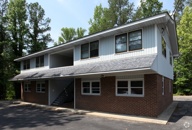
1426 E Nc Highway 54, Durham, NC 27713


Property Detail
1426 E Nc Highway 54
153034
PROP-ALPHIN OLIVER/LT#01 DBA/SEE COMMENTS PL:000000-000000
Officebuilding
Durham
OI
North Carolina
B and X Area of moderate flood hazard, usually the area between the limits of the 100-year and 500-year floods.
1
2025
0.86 AC
2025
South Durham
002013
Raleigh/Durham
4,706 SF
Durham-Chapel Hill, NC
NEARBY LISTINGS FOR SALE OR LEASE
DEMOGRAPHICS near 1426 E Nc Highway 54
1 mile
3 mile
5 mile
2024 Total Population
11,406
54,664
136,029
2029 Population
11,882
57,516
144,561
Pop Growth 2024-2029
+ 4.17%
+ 5.22%
+ 6.27%
Average Age
37
39
38
2024 Total Households
5,383
24,269
58,348
HH Growth 2024-2029
+ 4.25%
+ 5.37%
+ 6.45%
Median Household Inc
$99,493
$103,965
$101,222
Avg Household Size
2.10
2.20
2.20
2024 Avg HH Vehicles
2.00
2.00
2.00
Median Home Value
$416,645
$433,463
$460,508
Median Year Built
2000
1997
2001
Nearby Places
Map Layers
Map Styles
 Street
 Aerial
Transit
 Traffic
 Biking
Places
Listings with unknown addresses are not visible on the map
- Restaurants
- Banks
- Shops
- Fitness
- Groceries
PUBLIC TRANSPORTATION
COMMUTER RAIL
Drive
Walk
Distance
16 min
8.8 mi
AIRPORT
Raleigh-Durham International
Drive
Walk
Distance
Raleigh-Durham International
15 min
9.2 mi
SALE & LEASE HISTORY
LISTING DATE
SALE/LEASE

Apr 13, 2021
For Lease
Nearby Properties
Address
Land Use
TOTAL SIZE
Lot Size
Zoning
Address
Land Use
TOTAL SIZE
Lot Size
Zoning
778,433 SF
90.38 AC
CC(D)
Address
Land Use
TOTAL SIZE
Lot Size
Zoning
1,378,965 SF
183.46 AC
SRP
Address
Land Use
TOTAL SIZE
Lot Size
Zoning
868,283 SF
56.23 AC
SRP
Address
Land Use
TOTAL SIZE
Lot Size
Zoning
11,568 SF
39.56 AC
RS-M(D)
Address
Land Use
TOTAL SIZE
Lot Size
Zoning
444,254 SF
58.71 AC
SRP
Address
Land Use
TOTAL SIZE
Lot Size
Zoning
35.03 AC
RS-M(D)
Address
Land Use
TOTAL SIZE
Lot Size
Zoning
2.82 AC
SRP-C
Address
Land Use
TOTAL SIZE
Lot Size
Zoning
23,889 SF
50.95 AC
OI
Address
Land Use
TOTAL SIZE
Lot Size
Zoning
7,080 SF
30.67 AC
OI,RS-M
Address
Land Use
TOTAL SIZE
Lot Size
Zoning
6,948 SF
21.22 AC
RS-M(D)
Address
Land Use
TOTAL SIZE
Lot Size
Zoning
10,143 SF
46.78 AC
PDR 5.940
Address
Land Use
TOTAL SIZE
Lot Size
Zoning
7,241 SF
25.34 AC
PDR 5.370
Address
Land Use
TOTAL SIZE
Lot Size
Zoning
8,199 SF
28.28 AC
PDR 12.000
Address
Land Use
TOTAL SIZE
Lot Size
Zoning
555,485 SF
34.84 AC
SRP
Address
Land Use
TOTAL SIZE
Lot Size
Zoning
4,744 SF
12.90 AC
MU(D)
Address
Land Use
TOTAL SIZE
Lot Size
Zoning
9,816 SF
26.57 AC
RS-M
Address
Land Use
TOTAL SIZE
Lot Size
Zoning
13,634 SF
32.31 AC
RS-M
Address
Land Use
TOTAL SIZE
Lot Size
Zoning
12,864 SF
24.27 AC
RS-M
Address
Land Use
TOTAL SIZE
Lot Size
Zoning
240,537 SF
43.98 AC
IL
Address
Land Use
TOTAL SIZE
Lot Size
Zoning
217,507 SF
71.32 AC
CG(D)
Address
Land Use
TOTAL SIZE
Lot Size
Zoning
12,432 SF
26.15 AC
RS-M(D)
Address
Land Use
TOTAL SIZE
Lot Size
Zoning
411,834 SF
29.02 AC
IP(D)
Address
Land Use
TOTAL SIZE
Lot Size
Zoning
12,366 SF
46.02 AC
RS-M(D)
Address
Land Use
TOTAL SIZE
Lot Size
Zoning
12,150 SF
104.62 AC
SRP
Address
Land Use
TOTAL SIZE
Lot Size
Zoning
508,100 SF
500.24 AC
SRP
Address
Land Use
TOTAL SIZE
Lot Size
Zoning
11,748 SF
35.02 AC
PDR 8.130
Address
Land Use
TOTAL SIZE
Lot Size
Zoning
1,846 SF
31.05 AC
PDR 3.650
Address
Land Use
TOTAL SIZE
Lot Size
Zoning
8,030 SF
2.63 AC
SRP-C
Address
Land Use
TOTAL SIZE
Lot Size
Zoning
105.27 AC
SRP
Address
Land Use
TOTAL SIZE
Lot Size
Zoning
6,000 SF
27.57 AC
RS-M
The World's #1 Commercial Real Estate Marketplace
Connect with us
© 2026 CoStar Group
The information above has been obtained from sources believed reliable. While we do not doubt its accuracy we have not verified it and make no guarantee, warranty or representation about it. It is your responsibility to independently confirm its accuracy and completeness. Any projections, opinions, assumptions, or estimates used are for example only and do not represent the current or future performance of the property. The value of this transaction to you depends on tax and other factors which should be evaluated by your tax, financial, and legal advisors. You and your advisors should conduct a careful, independent investigation of the property to determine to your satisfaction the suitability of the property for your needs.