Property Record
1427 Crane Canyon Rd, Santa Rosa, CA 95404

NEARBY LISTINGS FOR SALE OR LEASE
Property Detail
1427 Crane Canyon Rd
Santa Rosa, CA
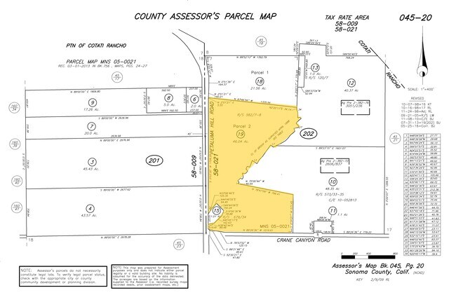
Parcel Map No Mns 05 0021
045-202-019
2014 FM REM 045-202-017 MNS 05-0021 PCL 2
Vineyard
Sonoma
X
California
06097C0881E
46.04 AC
2024
Santa Rosa
2025
North Bay/Santa Rosa
151800
DEMOGRAPHICS near 1427 Crane Canyon Rd
1 Mile
3 Mile
5 Mile
2024 Total Population
1,863
35,620
109,695
2029 Population
1,823
35,459
108,584
Pop Growth 2024-2029
(2.15%)
(0.45%)
(1.01%)
Average Age
42
41
40
2024 Total Households
672
13,692
39,640
HH Growth 2024-2029
(2.23%)
(0.56%)
(1.07%)
Median Household Inc
$96,286
$93,332
$88,378
Avg Household Size
2.80
2.50
2.70
2024 Avg HH Vehicles
2.00
2.00
2.00
Median Home Value
$751,160
$692,455
$701,044
Median Year Built
1984
1981
1981
Nearby Places
Map Layers
Map Styles
 Street
 Aerial
- Restaurants
- Banks
- Shops
- Fitness
- Groceries
PUBLIC TRANSPORTATION
COMMUTER RAIL
Cotati Smart (Main Line - Sonoma Marin Area Rail Transit)
DRIVE
WALK
Distance
Cotati Smart (Main Line - Sonoma Marin Area Rail Transit)
7 min
3.8 mi
Rohnert Park Smart (Main Line - Sonoma Marin Area Rail Transit)
DRIVE
WALK
Distance
Rohnert Park Smart (Main Line - Sonoma Marin Area Rail Transit)
8 min
4.0 mi
AIRPORT
Charles M Schulz - Sonoma County
DRIVE
WALK
Distance
Charles M Schulz - Sonoma County
22 min
14.3 mi
Freight Ports
Port of Richmond
DRIVE
WALK
Distance
Port of Richmond
60 min
42.6 mi
Nearby Properties
Address
Land Use
TOTAL SIZE
Lot Size
Zoning
Address
Land Use
TOTAL SIZE
Lot Size
Zoning
123,512 SF
15.83 AC
CITYRP
Address
Land Use
TOTAL SIZE
Lot Size
Zoning
270,526 SF
8.08 AC
Address
Land Use
TOTAL SIZE
Lot Size
Zoning
194,396 SF
7.36 AC
Address
Land Use
TOTAL SIZE
Lot Size
Zoning
187,024 SF
8.64 AC
Address
Land Use
TOTAL SIZE
Lot Size
Zoning
229,265 SF
3.03 AC
RM
Address
Land Use
TOTAL SIZE
Lot Size
Zoning
91,624 SF
4.94 AC
CITYRP
Address
Land Use
TOTAL SIZE
Lot Size
Zoning
180,934 SF
5.55 AC
CITYRP
Address
Land Use
TOTAL SIZE
Lot Size
Zoning
213,331 SF
12.53 AC
CREC
Address
Land Use
TOTAL SIZE
Lot Size
Zoning
142,759 SF
13.15 AC
CRPD
Address
Land Use
TOTAL SIZE
Lot Size
Zoning
87,286 SF
3.03 AC
Address
Land Use
TOTAL SIZE
Lot Size
Zoning
61,880 SF
2.53 AC
Address
Land Use
TOTAL SIZE
Lot Size
Zoning
107,599 SF
2.98 AC
Address
Land Use
TOTAL SIZE
Lot Size
Zoning
67,584 SF
4.79 AC
CITYRP
Address
Land Use
TOTAL SIZE
Lot Size
Zoning
77,660 SF
2.09 AC
CITYRP
Address
Land Use
TOTAL SIZE
Lot Size
Zoning
81,712 SF
5.64 AC
CITYRP
Address
Land Use
TOTAL SIZE
Lot Size
Zoning
69,431 SF
4.69 AC
Address
Land Use
TOTAL SIZE
Lot Size
Zoning
76,420 SF
2.34 AC
Address
Land Use
TOTAL SIZE
Lot Size
Zoning
Address
Land Use
TOTAL SIZE
Lot Size
Zoning
5,830 SF
5.50 AC
CITYRP
Address
Land Use
TOTAL SIZE
Lot Size
Zoning
43,877 SF
2.78 AC
Address
Land Use
TOTAL SIZE
Lot Size
Zoning
61,164 SF
6.25 AC
MR
Address
Land Use
TOTAL SIZE
Lot Size
Zoning
139,025 SF
8.36 AC
CITYRP
Address
Land Use
TOTAL SIZE
Lot Size
Zoning
32,288 SF
2.06 AC
CITYRP
Address
Land Use
TOTAL SIZE
Lot Size
Zoning
39,552 SF
2.93 AC
Address
Land Use
TOTAL SIZE
Lot Size
Zoning
4.19 AC
CITYRP
Address
Land Use
TOTAL SIZE
Lot Size
Zoning
131,658 SF
8.25 AC
MLPD
Address
Land Use
TOTAL SIZE
Lot Size
Zoning
145,953 SF
12.96 AC
CSPD
Address
Land Use
TOTAL SIZE
Lot Size
Zoning
6.16 AC
RM
Address
Land Use
TOTAL SIZE
Lot Size
Zoning
34,329 SF
0.74 AC
CITYRP
Address
Land Use
TOTAL SIZE
Lot Size
Zoning
104,491 SF
0.14 AC
CRPD
The World's #1 Commercial Real Estate Marketplace
Connect with us
© 2025 CoStar Group
The information above has been obtained from sources believed reliable. While we do not doubt its accuracy we have not verified it and make no guarantee, warranty or representation about it. It is your responsibility to independently confirm its accuracy and completeness. Any projections, opinions, assumptions, or estimates used are for example only and do not represent the current or future performance of the property. The value of this transaction to you depends on tax and other factors which should be evaluated by your tax, financial, and legal advisors. You and your advisors should conduct a careful, independent investigation of the property to determine to your satisfaction the suitability of the property for your needs.