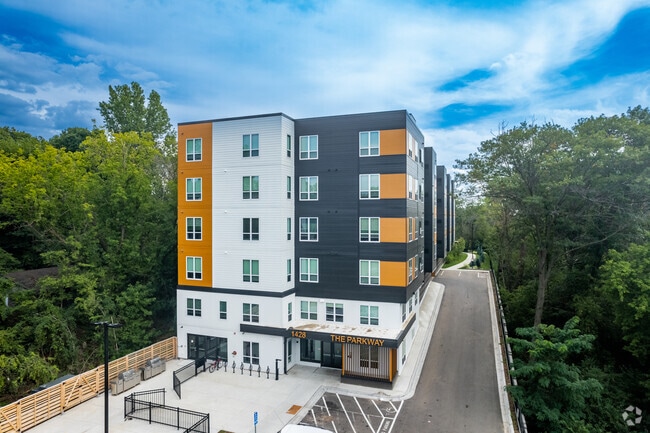
Property Record
1428 7Th St E, Saint Paul, MN 55106
NEARBY LISTINGS FOR SALE OR LEASE
Property Detail
1428 7Th St E
Minneapolis-St. Paul-Bloomington, MN-WI
Cruickshanks Garden Lots
27-29-22-34-0123
CRUICKSHANKS GARDEN LOTS EX ST N PART MEASURING 312 49/1OO FT ON E ...83/1OO FT ON W L OF LOT 8 BLK 4
Apartment
Ramsey
X
Minnesota
27037C0050E
8
2024
1.36 AC
2025
Parkway-Greenbrier
031702
Minneapolis/St Paul
DEMOGRAPHICS near 1428 7Th St E
1 mile
3 mile
5 mile
2024 Total Population
27,024
131,680
307,909
2029 Population
26,134
127,656
303,418
Pop Growth 2024-2029
(3.29%)
(3.06%)
(1.46%)
Average Age
32
35
37
2024 Total Households
8,503
46,286
116,502
HH Growth 2024-2029
(3.63%)
(3.10%)
(1.37%)
Median Household Inc
$55,584
$61,385
$65,638
Avg Household Size
3.00
2.70
2.50
2024 Avg HH Vehicles
2.00
2.00
2.00
Median Home Value
$182,391
$218,424
$250,889
Median Year Built
1957
1960
1965
Nearby Places
Map Layers
Map Styles
 Street
 Aerial
Transit
 Traffic
 Biking
Places
Listings with unknown addresses are not visible on the map
- Restaurants
- Banks
- Shops
- Fitness
- Groceries
PUBLIC TRANSPORTATION
COMMUTER RAIL
St. Paul-Minneapolis (Empire Builder - Amtrak)
Drive
Walk
Distance
St. Paul-Minneapolis (Empire Builder - Amtrak)
6 min
3.2 mi
AIRPORT
Minneapolis-St Paul International/Wold-Chamberlain
Drive
Walk
Distance
Minneapolis-St Paul International/Wold-Chamberlain
21 min
12.6 mi
Freight Ports
Port Milwaukee
Drive
Walk
Distance
Port Milwaukee
361 min
327.5 mi
Nearby Properties
Address
Land Use
TOTAL SIZE
Lot Size
Zoning
Address
Land Use
TOTAL SIZE
Lot Size
Zoning
384,515 SF
18.04 AC
Address
Land Use
TOTAL SIZE
Lot Size
Zoning
384,515 SF
1.33 AC
Address
Land Use
TOTAL SIZE
Lot Size
Zoning
267,948 SF
372.92 AC
Address
Land Use
TOTAL SIZE
Lot Size
Zoning
408.23 AC
Address
Land Use
TOTAL SIZE
Lot Size
Zoning
420,177 SF
2.13 AC
Address
Land Use
TOTAL SIZE
Lot Size
Zoning
759,622 SF
2.66 AC
Address
Land Use
TOTAL SIZE
Lot Size
Zoning
786,042 SF
2.10 AC
Address
Land Use
TOTAL SIZE
Lot Size
Zoning
643,305 SF
1.93 AC
Address
Land Use
TOTAL SIZE
Lot Size
Zoning
793,465 SF
1.93 AC
Address
Land Use
TOTAL SIZE
Lot Size
Zoning
160,800 SF
5.05 AC
Address
Land Use
TOTAL SIZE
Lot Size
Zoning
393,443 SF
3.75 AC
Address
Land Use
TOTAL SIZE
Lot Size
Zoning
460,439 SF
25.26 AC
Address
Land Use
TOTAL SIZE
Lot Size
Zoning
47,670 SF
179 AC
Address
Land Use
TOTAL SIZE
Lot Size
Zoning
207.61 AC
Address
Land Use
TOTAL SIZE
Lot Size
Zoning
364,480 SF
8.33 AC
Address
Land Use
TOTAL SIZE
Lot Size
Zoning
13.10 AC
Address
Land Use
TOTAL SIZE
Lot Size
Zoning
401,435 SF
1.92 AC
Address
Land Use
TOTAL SIZE
Lot Size
Zoning
343,308 SF
2.90 AC
Address
Land Use
TOTAL SIZE
Lot Size
Zoning
468,732 SF
0.52 AC
Address
Land Use
TOTAL SIZE
Lot Size
Zoning
32,159 SF
448.26 AC
Address
Land Use
TOTAL SIZE
Lot Size
Zoning
330,202 SF
6.27 AC
Address
Land Use
TOTAL SIZE
Lot Size
Zoning
3,080 SF
9.37 AC
Address
Land Use
TOTAL SIZE
Lot Size
Zoning
273,937 SF
16.75 AC
Address
Land Use
TOTAL SIZE
Lot Size
Zoning
53,851 SF
22.74 AC
Address
Land Use
TOTAL SIZE
Lot Size
Zoning
180,756 SF
40.63 AC
Address
Land Use
TOTAL SIZE
Lot Size
Zoning
311,332 SF
36.34 AC
Address
Land Use
TOTAL SIZE
Lot Size
Zoning
181.88 AC
Address
Land Use
TOTAL SIZE
Lot Size
Zoning
246,000 SF
31.03 AC
Address
Land Use
TOTAL SIZE
Lot Size
Zoning
73,933 SF
2.50 AC
Address
Land Use
TOTAL SIZE
Lot Size
Zoning
224,944 SF
3.15 AC
The World's #1 Commercial Real Estate Marketplace
Connect with us
© 2026 CoStar Group
The information above has been obtained from sources believed reliable. While we do not doubt its accuracy we have not verified it and make no guarantee, warranty or representation about it. It is your responsibility to independently confirm its accuracy and completeness. Any projections, opinions, assumptions, or estimates used are for example only and do not represent the current or future performance of the property. The value of this transaction to you depends on tax and other factors which should be evaluated by your tax, financial, and legal advisors. You and your advisors should conduct a careful, independent investigation of the property to determine to your satisfaction the suitability of the property for your needs.